Contributory members are able to log private notes and comments about each site
Sites theCAptain has logged. View this log as a table or view the most recent logs from everyone
Madron Well
Date Added: 18th Sep 2010
Site Type: Holy Well or Sacred Spring
Country: England (Cornwall)
Visited: Yes on 21st Jan 2004
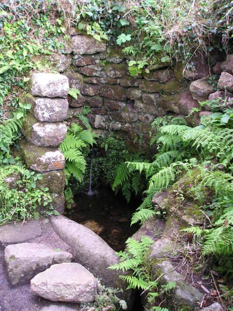
Madron Well submitted by thecaptain on 21st Jan 2004. Madron Baptistry
(View photo, vote or add a comment)
Log Text: None
Madron Well
Date Added: 13th Jul 2023
Site Type: Holy Well or Sacred Spring
Country: England (Cornwall)
Visited: Yes on 13th Jun 2023. My rating: Condition 4 Ambience 5 Access 4

Madron Well submitted by Bladup on 9th Aug 2016. The elemental Madron Well.
(View photo, vote or add a comment)
Log Text: Despite it being very foggy, I decide I have to visit Madron Well, and anyway, it all adds to the atmosphere. When I get to the watery bit by the path, there is not so much tat hanging in the trees as I was expecting, and most of what there is is either real strips of cloth or floral offerings. Despite having a bad foot, and only wearing sandals, I decide I want to try and find the proper well, but soon get beaten with the marshy conditions and my unsteady legs. With nothing to hold on to, at one point I slip, try to adjust my footing onto a duckboard, but that then moves under me and I am down on my ass in the mud and water. Oh well, make the most of it and douse my bad toe in the water. Has to be said that after more than 3 months of not healing, the scar started to turn into a proper scab after this, and was properly healing by the end of the week.
Madacombe
Date Added: 18th Sep 2010
Site Type: Stone Row / Alignment
Country: England (Somerset)
Visited: Yes on 27th Sep 2006
Madacombe submitted by thecaptain on 27th Sep 2006. Madacombe stone row, Exmoor. Its in there somewhere.
Could I find anything ? No chance !!!! I found nothing at all, wading around in waist deep wet grass and heather. If there are any stones to be found here, they are well hidden under the wet moorland growth. I did however, get soaking wet and a twisted ankle for my efforts !
(View photo, vote or add a comment)
Log Text: None
Macellum of Pompeii
Date Added: 29th Oct 2019
Site Type: Modern Stone Circle etc
Country: Italy (Marche)
Visited: Yes on 15th Jun 2012
Macellum of Pompeii submitted by theCaptain on 15th Jun 2012. A circle of 12 volcanic tuff stones erected in the central Macellum of the ancient city of Pompeii.
(View photo, vote or add a comment)
Log Text: None
Lydney Harbour
Date Added: 29th Oct 2019
Site Type: Modern Stone Circle etc
Country: England (Gloucestershire)
Visited: Yes on 17th Feb 2019
Lydney Harbour submitted by TheCaptain on 17th Feb 2019. A modern circle of standing stones, with outliers, constructed between Lydney Harbour and the Severn Estuary.
(View photo, vote or add a comment)
Log Text: None
Luguenez menhir
Trip No.203 Entry No.483 Date Added: 26th May 2020
Site Type: Standing Stone (Menhir)
Country: France (Bretagne:Finistère (29))
Visited: Yes on 18th Jun 2005. My rating: Condition 3 Ambience 3 Access 4
Luguenez menhir submitted by theCaptain on 25th Jan 2010. About three metres in height, this nicely shaped menhir is getting lost in the hedges.
(View photo, vote or add a comment)
Log Text: More than three metres in height, this nicely shaped menhir is getting lost in the hedges of the little lane which runs to the coast behind and to the north of the farm. Not far from here are superb views over the Baie de Duarnenez and the wonderful cliffs all around, including the cliff castle of Kastell Koz just to the east.
Lugbury
Date Added: 6th Mar 2022
Site Type: Chambered Tomb
Country: England (Wiltshire)
Visited: Yes on 13th Apr 2004. My rating: Access 4

Lugbury submitted by thecaptain on 18th Sep 2007. What a disappointment this 60 metre length long barrow has become, with its remaining large stone portal structure completely overgrown.
The rest of the barrow doesn't fare much better, with large tree trunks and other stuff just dumped on it, while it also looks like it has been ploughed up to a bit closer than I remember.
(View photo, vote or add a comment)
Log Text: This large long barrow, which lies on an east west axis, is in a field just to the west of the Fosse Way. The remains of the barrow can clearly still be made out, and although the mound is now mostly gone, it is still clearly raised above the level of the field. The main remains of this tomb are however a large chamber at the eastern end, consisting of two large (2m) upright stones, with a fallen capstone leaning on them from behind. This capstone has a strange notch in it, which is now at the ground edge, nearer to the northern upright. It is said that this barrow once had four side chambers, which were found to have the remains of many skeletons in them.
Luffang Allée Couverte
Trip No.203 Entry No.346 Date Added: 10th May 2020
Site Type: Passage Grave
Country: France (Bretagne:Morbihan (56))
Visited: Yes on 11th Jun 2005. My rating: Condition 2 Ambience 4 Access 4

Luffang Allée Couverte submitted by ermine on 27th Jun 2004. 47.61309N 3.024552W
This passage-grave contained unique artwork on the end stone, now preserved in Carnac museum. Signposted at the site as Allee Couverte
(View photo, vote or add a comment)
Log Text: Easily found in woodland near Luffang, just to the west of Crac'h, this is the remains of a long allée-couverte type structure, but with no coverstones remaining. The allée is not straight, but turns to the left about 45° after 6 metres of the entrance, before another 14 metres of stonelined passageway takes you to the end. Although there are no capstones, many of the sidestones remain in position, and its in nice cool woodland on this hot afternoon.
I understand that there was once a particularly nicely carved stone making up a part of this monument, but I did not spot it on my visit. I wonder whether this site was once within a large mound, rather like the Kernourze tumulus ?
Luckington II
Date Added: 6th Mar 2022
Site Type: Chambered Tomb
Country: England (Wiltshire)
Visited: Yes on 6th Mar 2022. My rating: Condition 2 Ambience 3 Access 4

Luckington II submitted by TheCaptain on 8th Mar 2022. On the southern side of the lane opposite the Giant's Caves longbarrow is the large unkempt raise of the Luckington 2 longbarrow. I didn't go for a root around, and sitisfied myself with a few pics from over the hedge.
(View photo, vote or add a comment)
Log Text: Windy grey walk round Badminton estate, then a look at the Luckington long barrows, finishing with a pint at the Old Royal Ship. On the southern side of the lane opposite the Giant's Caves longbarrow is the large unkempt raise of the Luckington 2 longbarrow. I didn't go for a root around, and sitisfied myself with a few pics from over the hedge.
Luc-sur-Mer menhir
Date Added: 18th Sep 2010
Site Type: Standing Stone (Menhir)
Country: France (Normandie:Calvados (14))
Visited: Yes on 29th Dec 2006
Luc-sur-Mer menhir submitted by thecaptain on 29th Dec 2006. Remains of a menhir about a metre tall, which can be found beside a garden hedge at the eastern end of Rue du Menhir.
(View photo, vote or add a comment)
Log Text: None
Lower Swell barrow
Date Added: 18th Sep 2010
Site Type: Chambered Tomb
Country: England (Gloucestershire)
Visited: Yes on 5th Jan 2007
Lower Swell barrow submitted by thecaptain on 5th Jan 2007. The barrow can be seen under the bushes in its little enclosure at the far side of the cropped field - strangely well down the hillside.
(View photo, vote or add a comment)
Log Text: None
Lower Neuadd Reservoir Stone
Date Added: 29th Oct 2019
Site Type: Standing Stone (Menhir)
Country: Wales (Powys)
Visited: Yes on 16th Jun 2017
Lower Neuadd Reservoir Stone submitted by TheCaptain on 16th Jun 2017. The fallen and broken stone by the track (possible)
(View photo, vote or add a comment)
Log Text: None
Lower Broadmoor
Date Added: 3rd Nov 2019
Site Type: Standing Stone (Menhir)
Country: Wales (Pembrokeshire)
Visited: Yes on 5th Oct 2015. My rating: Condition 4 Ambience 3 Access 4
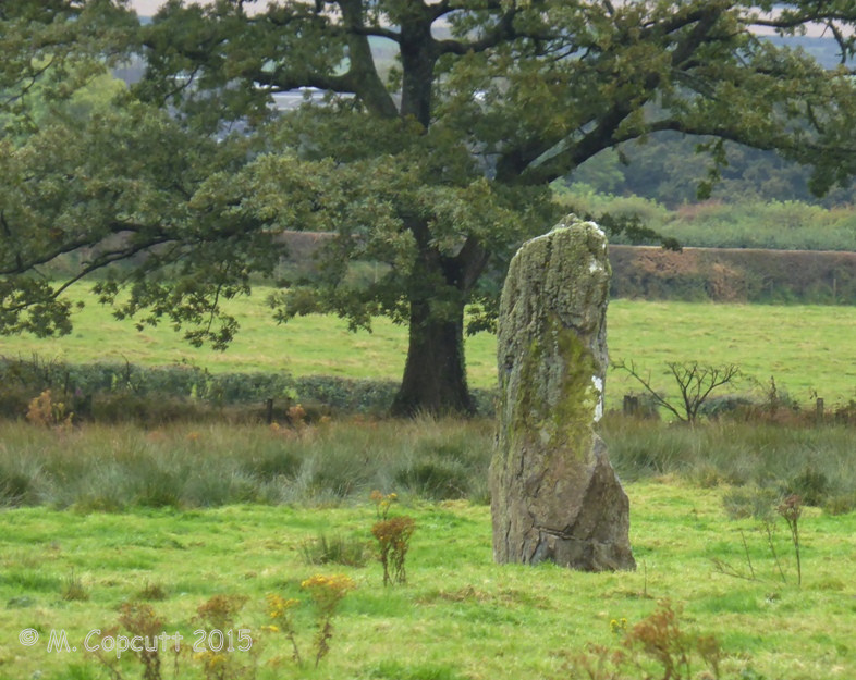
Lower Broadmoor submitted by TheCaptain on 21st Dec 2015. A 2.1 metre tall standing stone in a cattle field just to the south of Lower Broadmoor farm, a couple of kilometres to the north of Wolf's Castle in Pembrokeshire.
(View photo, vote or add a comment)
Log Text: A 2.1 metre tall standing stone in a cattle field just to the south of Lower Broadmoor farm, a couple of kilometres to the north of Wolf's Castle in Pembrokeshire. Not so easy to get to as it looks on the map, with many gates across the footpath and ankle deep mud caused by the cattle which use this track. When I saw a way into the field, it looked to be the best way to the stone, but a herd of young cattle saw me and came charging over towards me, so I skidaddled pretty quickly, getting wet in a boggy bit halfway up to my knees. I then satisfied myself with looking at this fine stone from the trackway, and noticed another huge stone in the hedge, which may have lost its top. Made me wonder if these were once a pair or more.
Lower Boscaswell Fougou
Date Added: 29th Jun 2023
Site Type: Souterrain (Fogou, Earth House)
Country: England (Cornwall)
Visited: Yes on 10th Jun 2023. My rating: Condition 3 Ambience 4 Access 4
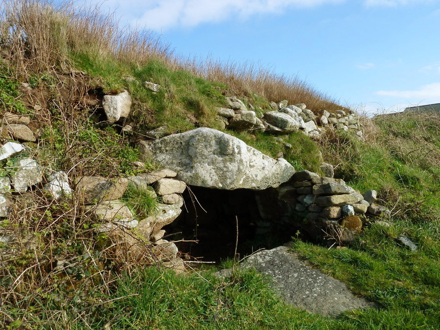
Lower Boscaswell Fougou submitted by Bladup on 7th Jun 2017. Lower Boscaswell Fogou.
(View photo, vote or add a comment)
Log Text: Dropping down from Carn Kenidjack, and after a slight detour to refresh myself at The North Inn, I head towards the coast and look for the Lower Boscaswell Fougou. Not being able to find it initially, I cheat and look it up on the portal. Ah, through the cow field and round the other side, over a stile and there it is. These days theres just a small chamber like space behind the opening, and daylight can be seen up a smaller side passage. Such a large stone area here, makes me wonder how big this might have once been. I'd better get on with my walk as time is getting on, and I have been getting further off route, so no time to try find the Pendeen one.
Low Longrigg SW
Date Added: 29th Oct 2019
Site Type: Stone Circle
Country: England (Cumbria)
Visited: Yes on 4th Oct 2017
Low Longrigg SW submitted by TheCaptain on 4th Oct 2017. Very hard to find in very long grass on very uneven and boggy ground, amongst many cairns all over the place. I found what I thought was the remnants of a stone circle, but was not 100% convinced.
(View photo, vote or add a comment)
Log Text: None
Low Longrigg NE
Date Added: 29th Oct 2019
Site Type: Stone Circle
Country: England (Cumbria)
Visited: Yes on 4th Oct 2017
Low Longrigg NE submitted by TheCaptain on 4th Oct 2017. Very hard to find in very long grass on very uneven and boggy ground, amongst many cairns all over the place.
Further up the ridge I again found what I thought was the remnants of a stone circle, but was not 100% convinced, but seemed too far from what I thought was the SW circle for them to both be correct.
(View photo, vote or add a comment)
Log Text: None
Low Bridestones (S) (Yorks)
Date Added: 7th Dec 2024
Site Type: Stone Row / Alignment
Country: England (Yorkshire (North))
Visited: Yes on 17th Sep 2024. My rating: Condition 4 Ambience 4 Access 3

Low Bridestones (S) (Yorks) submitted by Bladup on 14th Oct 2014. Low Bridestones.
(View photo, vote or add a comment)
Log Text: The sun is getting low and I consider giving up at this point, but I wisely decide that I do still have time to go and have a quick look for the southern of the three marked groups of stones, and I am very glad that I did. Walking southwards through some initially very difficult boggy ground with long couch grass, I find easier going up the hill a bit and then along what was presumably a sheep track. Then I see in the distance a row of about half a dozen stones standing proud of the moorland, showing clearly as shadows with the golden light of the settng sun behind. They look magnificent. Feeling good now that I have found them, I head over with a spring in my step, and not worrying about the boggy ground underfoot. Thank goodness I have my boots on! When I get there, the five or six large stones are clearly standing in an approximate straight line, but with many other smaller stones also with them. In the middle it seems to be a double row of stones about three or four feet apart, reminding me a bit of a Dartmoor double row. At the lower, southern end, any real form sort of disintegrates into a bit of raised ground with lots of stones almost in a heap. The light here is now just beautiful, all golden with a blue sky and green/brown moorland underfoot. Time to head back, and there looks to be a boggy stream between me and the bridle way back, but after a good look around I find a sheep track which leads me through the marsh ground and across to get me back to the bridleway. All my years of training on Dartmoor have paid off, as it is much easier going than much of that! Walking back to the north along the bridleway I see many large stones laying between the stony track and the nearby field wall. Could these possiby be the remnants of anther row of stones, or are they just large stones which have been moved and dumped out of the way of the track? Its hard to know. Back to the car and time to go for a celebratory pint. It has been another great day, with some grade 1 stone hunting this early evening, and I have a real feeling of achievement.
Low Bridestones (N) (Yorks)
Date Added: 6th Dec 2024
Site Type: Standing Stones
Country: England (Yorkshire (North))
Visited: Yes on 17th Sep 2024. My rating: Condition 3 Ambience 3 Access 3

Low Bridestones (N) (Yorks) submitted by oldman on 22nd Apr 2018. A group of the Low Bride Stones near Grosmont on the North York Moors.
(View photo, vote or add a comment)
Log Text: From the High Bridestones I now drive down the hill to the northwest and am able to park in a big area where the bridleway crosses, and an entry road to a quarry. From here it is easy to walk out towards the Lower Bridestones, which I don’t remember finding before (I was being rushed), but it is now much easier with the detailed maps available through the Megalithic Portal which show three groups of stones. A couple of hundred yards along the bridleway and then head southeast up the slope to look for the first of three groups marked on the detailed OS map. Yes, theres the top of a stone peeking above the long grass. And another. Three in a line to start, then a good look around in the boggy ground and there are many stones to be found, maybe a couple of lines across the slope, but to be honest, they could be almost anything. I now see a couple of bigger stones standing above the long grass to the west of here, which must be the second group, so head over towards them, which is not quite so straightforward with the long couchgrass and a very boggy area between me and them. Approaching them and I can first see three stones standing in a line across the slope, and several confusing sheep, which look just like more. When I get to them, it is clear that there are many more stones here, again forming a perhaps a couple of lines around the hill, but its all a bit obscured in the long marsh grass, and a bit of a megalithic mess. The upper line seems to go on for a fair distance, with one stone after another to be found. Further over to the northeast a sort of circle of stones is shown on the map, so I wander over for a look. Without GPS and detailed map ths would be impossible to find, but I do get here and find a small cairn like pile of stones, but no semblance of a stone circle.
Louden west
Date Added: 18th Sep 2010
Site Type: Ancient Village or Settlement
Country: England (Cornwall)
Visited: Yes on 2nd Apr 2005
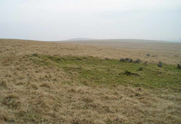
Louden west submitted by TheCaptain on 2nd Apr 2005. On the western slopes of Louden Hill are the remains of some very fine hut circles.
(View photo, vote or add a comment)
Log Text: None
Louden Tor
Date Added: 18th Sep 2010
Site Type: Natural Stone / Erratic / Other Natural Feature
Country: England (Cornwall)
Visited: Yes on 31st Mar 2005
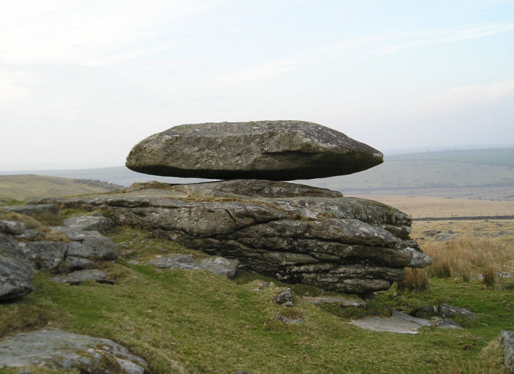
Louden Tor submitted by TheCaptain on 31st Mar 2005. Louden Tor Logan stone.
View looking north.
(View photo, vote or add a comment)
Log Text: None
