Contributory members are able to log private notes and comments about each site
Sites theCAptain has logged. View this log as a table or view the most recent logs from everyone
Kerugou dolmen
Trip No.203 Entry No.469 Date Added: 25th May 2020
Site Type: Burial Chamber or Dolmen
Country: France (Bretagne:Finistère (29))
Visited: Yes on 17th Jun 2005. My rating: Condition 3 Ambience 4 Access 5
Kerugou dolmen submitted by minteddy on 5th Dec 2006. 3 - 4 km east of Troenen in Penmarch south west Finisterre.
View from west looking east down the length of the passage. The concrete pillar supporing the cap stone has gone.
On mappy.com enter place Kerugou, postcode 29120. View aerial photo at street level and about 200 metres north west of post code address (on aerial photo it is at south east corner of mini triangular village green) you'll see dolmen by different colour in field to north west of mini triangular village green.
(View photo, vote or add a comment)
Log Text: Kerugou dolmen is an interesting one, which can be found just inside a field beside a small road and signposted. It has a large compartmented chamber at the back, western end, with a long central passageway opening up to the east, at orientation 097°. The central passage is about 9 metres long and up to 2m in width away from the entrance. The two side chambers align along the back wall, and are each 3m by 2.5m, with some massive side slabs. Unfortunately, there is only one capstone still in place, and that is on the entrance passageway, but it's a nice monument to discover. Much of its mound is still in place.
Kervadol Dolmens
Trip No.203 Entry No.461 Date Added: 25th May 2020
Site Type: Burial Chamber or Dolmen
Country: France (Bretagne:Finistère (29))
Visited: Yes on 17th Jun 2005. My rating: Condition 3 Ambience 3 Access 5
Kervadol dolmens submitted by minteddy on 4th Dec 2006. You can see the two dolmen together in this view
(View photo, vote or add a comment)
Log Text: This is the remains of two little dolmens about 10 metres away from each other, not far from the sports fields. I could not be sure as to whether they were once in different mounds, or if they would have both been in the same one. Both have similar chambers, with a capstone sitting on a couple of side stones each side, and facing south.
The eastern of the two is in much better condition, and the capstone is in its proper position. That on the western dolmen has fallen to one side. Both of these dolmens have a strange feature which is a large square slab lined hollow beside them on the eastern side, or perhaps on both sides. Would these have been side chambers ? There is no sign of any capstones, and any entrance would have had to have been round the back. It's all very odd. These slabs are perhaps a bit like the stones around the Lesconil dolmen, except that the mound is outside of these rather than on the inside.
I later found out that these are remains of a type of monument only found in this coastal part of southwest Brittany, and are compartmented dolmens, which had chambers with internal compartment slabs to break up the chamber into sections.
Kervehennec Dolmen
Trip No.203 Entry No.364 Date Added: 11th May 2020
Site Type: Burial Chamber or Dolmen
Country: France (Bretagne:Morbihan (56))
Visited: Yes on 12th Jun 2005. My rating: Condition 3 Ambience 3 Access 4
Kervehennec dolmen submitted by TheCaptain on 12th Jun 2011. In a little area behind Kervehennic farm can be seen the remains of this dolmen still largely in its tumulus on top of a little granite hillock.
(View photo, vote or add a comment)
Log Text: To the north of the D781 road, in a little area behind Kervanhennic farm can be seen the remains of this fairly wrecked dolmen on top of a little granite hillock. There is not much more than a single 3 m by 2 metres capstone and a few support stones to be seen. It looks to have had a wall built into it in the past, and it is becoming overgrown.
Kervengu Dolmen
Trip No.203 Entry No.343 Date Added: 10th May 2020
Site Type: Burial Chamber or Dolmen
Country: France (Bretagne:Morbihan (56))
Visited: Saw from a distance on 11th Jun 2005. My rating: Condition 3 Ambience 3
Kervengu dolmen submitted by thecaptain on 11th May 2006. This is a nice looking dolmen in the middle of a field of sweetcorn, with no obvious access to it.
(View photo, vote or add a comment)
Log Text: This is a nice looking dolmen in the middle of a field of sweetcorn, with no obvious access to it. From a distance, it looks like a single large capstone on top of three supports, but this is probably wrong. There is a tree growing beside it.
Kervéresse Dolmen
Trip No.203 Entry No.359 Date Added: 11th May 2020
Site Type: Burial Chamber or Dolmen
Country: France (Bretagne:Morbihan (56))
Visited: Saw from a distance on 12th Jun 2005
Kervéresse Dolmen submitted by TheCaptain on 12th Jun 2011. I think that's it there, in that mound of dense undergrowth !
(View photo, vote or add a comment)
Log Text: I couldn’t be sure that I found this dolmen, what I did see was a bit of a mound covered in thick undergrowth in a private garden beside the D718 road to the north of Locmariaquer.
Kervignon Dolmen
Trip No.203 Entry No.460 Date Added: 25th May 2020
Site Type: Burial Chamber or Dolmen
Country: France (Bretagne:Finistère (29))
Visited: Yes on 17th Jun 2005. My rating: Condition 3 Ambience 3 Access 5
Kervignon dolmen submitted by minteddy on 9th Aug 2006. Kervignon dolmen
This dolmen is behind the sports ground in Plobannalec on the road to Lesconil. The photograph was taken Monday 31 July 2006 at about 15:30 French time in the pouring rain
(View photo, vote or add a comment)
Log Text: This little dolmen, with a capstone sitting on three side slabs is to be found round the back of the local sports centre. The capstone is nicely rain worn on the top, and sits at a jaunty angle. It perhaps once had an entry corridor as the side stones are smaller at one end, and I believe that this is in fact the remains of what was once a compartmented dolmen, with much of the rest of it destroyed.
Keryvon allée couverte
Trip No.203 Entry No.556 Date Added: 3rd Jun 2020
Site Type: Passage Grave
Country: France (Bretagne:Côtes-D'Armor (22))
Visited: Yes on 24th Jun 2005. My rating: Condition 3 Ambience 3 Access 5
Keryvon allée couverte submitted by thecaptain on 27th Feb 2007. Right beside the D.788 road from Trébeurden to Trégastel, is the remains of what initially looks like a dolmen, but is part of what was once an allée couverte.
It has a single capstone on side supports only, but there are at least three of them on the south side, and possibly more.
(View photo, vote or add a comment)
Log Text: Right beside the D.788 road from Trébeurden to Trégastel, and only feet from the cliff edge is the remains of this dolmen, but it would not surprise me if it is part of what was once an allée couverte. It has a single capstone on side supports only, but there are at least three of them on the south side, and possibly more.
Survival of this has again been helped by it being part of a wall, but I suspect the road has cut off the eastern end. Orientation is 094°. Further into the hedge, and I think that there are a few peristalith stones also.
Keryvon allée couverte
Trip No.214 Entry No.20 Date Added: 3rd Jun 2020
Site Type: Passage Grave
Country: France (Bretagne:Côtes-D'Armor (22))
Visited: Yes on 17th Apr 2014. My rating: Condition 3 Ambience 3 Access 5
Keryvon allée couverte submitted by thecaptain on 27th Feb 2007. Right beside the D.788 road from Trébeurden to Trégastel, and only feet from the cliff edge, is the remains of this allée couverte.
It has a single capstone on side supports only, but there are at least three of them on the south side, and possibly more. At the back, near the hedge, I think that there are a few peristalith stones also.
(View photo, vote or add a comment)
Log Text: Doing a little coastal route after leaving Ploumanach, and the remains of this allée couverte are right beside the D.788 road from Trébeurden to Trégastel, only feet from the cliff edge.
Keryvon allée couverte
Trip No.193 Entry No.12 Date Added: 13th Jul 2020
Site Type: Passage Grave
Country: France (Bretagne:Côtes-D'Armor (22))
Visited: Yes on 30th May 1993
Keryvon allée couverte submitted by thecaptain on 27th Feb 2007. Right beside the D.788 road from Trébeurden to Trégastel, and only feet from the cliff edge, is the remains of this allée couverte.
It has a single capstone on side supports only, but there are at least three of them on the south side, and possibly more. At the back, near the hedge, I think that there are a few peristalith stones also.
(View photo, vote or add a comment)
Log Text: Cycling camping trip of north Brittany, day 2. Tregastel, Ile Grande, Tel Star Satellite place. Snake! Lots of ancient stones.
Kerzerho Alignements
Trip No.203 Entry No.407 Date Added: 14th May 2020
Site Type: Multiple Stone Rows / Avenue
Country: France (Bretagne:Morbihan (56))
Visited: Yes on 13th Jun 2005. My rating: Condition 5 Ambience 4 Access 5
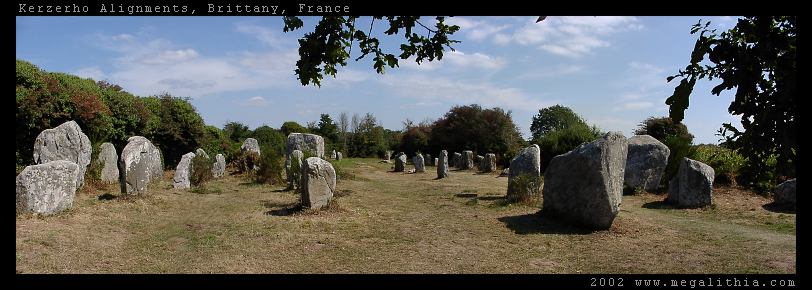
Kerzerho Alignements submitted by ermine on 1st Jul 2004. Kerzerho Alignments
Brittany, Morbihan
47.634690N 3.148402W GPS onsite
You can still walk among the stones at Kerzerho (in 2002 at east) which are near Carnac but not quite so busy. Head up the D781 to Erdeven. You can park nearby, and from there you can also take the path to the large stones of the Table du Sacrifice
(View photo, vote or add a comment)
Log Text: It’s a pity about the busy road running through them, but they are here, looking superb in the sun and you can wander freely amongst them. However, I just want to get back now, having spent almost an hour fixing my bike. There is a Dutch couple here, the man spending ages taking photos with all sorts of kit. Three big bags worth. And wifey posing in front of the stones. These Dutch, eh ? There are a fantastic number of stones in the field here, some of them really lovely shapes.
Kerzerho Alignements
Trip No.203 Entry No.435 Date Added: 23rd May 2020
Site Type: Multiple Stone Rows / Avenue
Country: France (Bretagne:Morbihan (56))
Visited: Yes on 15th Jun 2005. My rating: Condition 5 Ambience 4 Access 5

Kerzerho Alignements submitted by ermine on 1st Jul 2004. Kerzerho Alignments
Brittany, Morbihan
47.634690N 3.148402W GPS onsite
You can still walk among the stones at Kerzerho (in 2002 at east) which are near Carnac but not quite so busy. Head up the D781 to Erdeven. You can park nearby, and from there you can also take the path to the large stones of the Table du Sacrifice
(View photo, vote or add a comment)
Log Text: Such wonderful stones, I just had to stop and wander around them again.
Kestor Settlement
Date Added: 18th Sep 2010
Site Type: Ancient Village or Settlement
Country: England (Devon)
Visited: Yes on 24th Oct 2004
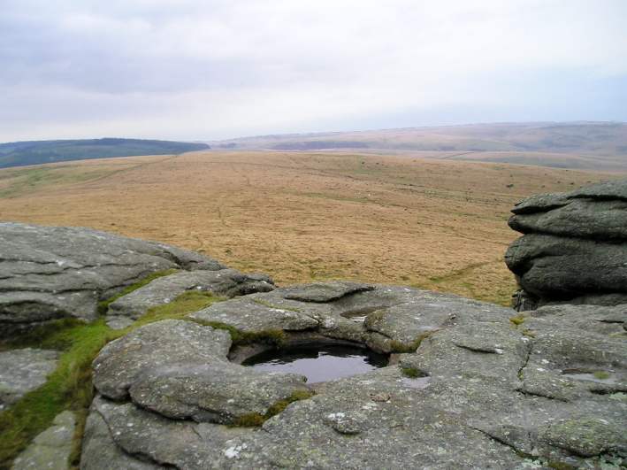
Kestor Settlement submitted by thecaptain on 24th Oct 2004. Kestor Rock Basin. View from the top of Kestor rocks looking southwest towards Shovel Down. This is the largest natural rock basin on Dartmoor, it is about 3 feet in diameter and is at least 2 feet deep with water throughout most of the year. I wonder if it was significant to the ancient settlers here.
(View photo, vote or add a comment)
Log Text: None
Kiftsgate Stone
Date Added: 16th Sep 2021
Site Type: Holed Stone
Country: England (Gloucestershire)
Visited: Yes on 6th Sep 2021. My rating: Condition 2 Ambience 3 Access 5

Kiftsgate Stone submitted by geraldaf on 15th Mar 2013. Stone fett warm
(View photo, vote or add a comment)
Log Text: Cotswold Way walk from Chipping Campden to Broadway, making sure to have a look at the Kiftsgate Stone, which was well hidden amongst undergrowth, despite being just to the side of the road. Looked to me like it might possibly have once been part of a longbarrow chamber.
Killievair
Date Added: 29th Oct 2019
Site Type: Standing Stone (Menhir)
Country: Scotland (Angus)
Visited: Yes on 1st Nov 2018

Killievair submitted by TheCaptain on 1st Nov 2018. Borrowed from Historic Environment Scotland facebook page.
"While visiting the Killievair Standing Stone near Brechin recently, one of our Heritage Casework Team field officers found it had fallen over.
We commissioned the re-erection of the stone so the public could appreciate the monument as it was supposed to be.
This involved moving the stone, undertaking an excavation to record its socket and check for burials, and then re-erecting the stone in a new socket in its original locati...
(View photo, vote or add a comment)
Log Text: None
King Arthur's Down NW
Date Added: 18th Sep 2010
Site Type: Stone Circle
Country: England (Cornwall)
Visited: Yes on 24th Mar 2005
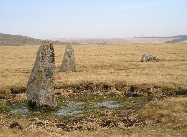
King Arthur's Down NW submitted by TheCaptain on 24th Mar 2005. King Arthur’s Down NW stone circle.
The three stones of the northern arc which are still standing.
Even on a nice dry day after a long dry spell, beware the pools of bog which will catch the unwary - or those not looking where they are walking !
(View photo, vote or add a comment)
Log Text: None
King Arthur's Down SE
Date Added: 18th Sep 2010
Site Type: Stone Circle
Country: England (Cornwall)
Visited: Yes on 24th Mar 2005
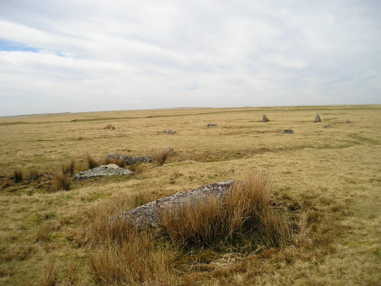
King Arthur's Down SE submitted by TheCaptain on 24th Mar 2005. King Arthur’s Down SE stone circle.
View of the 4 large fallen slabs in the southwest quadrant. The NW circle is seen beyond.
(View photo, vote or add a comment)
Log Text: None
King Arthur's Hall
Date Added: 18th Sep 2010
Site Type: Standing Stones
Country: England (Cornwall)
Visited: Yes on 5th Apr 2005
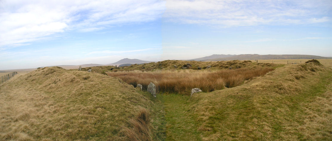
King Arthur's Hall submitted by TheCaptain on 5th Apr 2005. King Arthur's Hall, seen here looking northeast through the entrance.
Taken from the stile at the entry to its fenced off enclosure. Roughtor and Brown Willy on the horizon
(View photo, vote or add a comment)
Log Text: None
King Arthur's Round Table
Date Added: 20th Oct 2022
Site Type: Henge
Country: England (Cumbria)
Visited: Yes on 20th Sep 2022. My rating: Condition 3 Ambience 2 Access 5
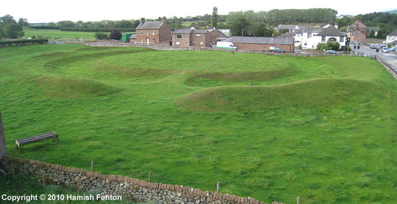
King Arthur's Round Table submitted by h_fenton on 1st Oct 2010. King Arthur's Round Table.
I tried to fly the kite here but the wind was too inconsistent to safely get the camera high enough. Here instead of a kite I used a carp fishing pole, with a camera attachment on the end to lift my camera higher (6-7 metres).
10 September 2010
(View photo, vote or add a comment)
Log Text: From Mayburgh I walk to King Arthur's Round Table, and then pop into its field for a walk around the outside. Much smaller, and more henge like than the nearby Mayburgh, this has the ditch well inside the outer bank. Unfortunately, being so close to the busy roads, it suffers a fair bit in the ambience stakes.
King Doniert's Stone
Date Added: 29th Oct 2019
Site Type: Ancient Cross
Country: England (Cornwall)
Visited: Yes on 3rd Jan 2019
King Doniert's Stone submitted by TheCaptain on 3rd Jan 2019. Inspecting the inscription on King Doniert's Stone in 1973
(View photo, vote or add a comment)
Log Text: None
King Henry's Mound
Date Added: 18th Sep 2010
Site Type: Artificial Mound
Country: England (Greater London)
Visited: Yes on 1st Jan 2006
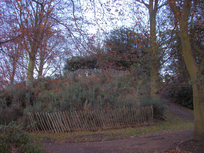
King Henry's Mound submitted by thecaptain on 1st Jan 2006. King Henry's Mound is a much modified large mound in Richmond Park.
(View photo, vote or add a comment)
Log Text: None
