Contributory members are able to log private notes and comments about each site
Sites theCAptain has logged. View this log as a table or view the most recent logs from everyone
Langstone Moor stone row
Date Added: 18th Sep 2010
Site Type: Stone Row / Alignment
Country: England (Devon)
Visited: Yes on 18th Sep 2007
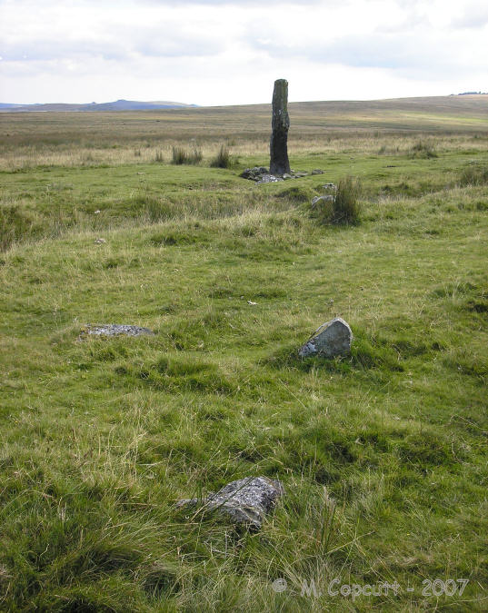
Langstone Moor stone row submitted by TheCaptain on 18th Sep 2007. Running off to the north from the Langstone is the remains of a stone row, which can be followed for about 100 metres before it runs out.
(View photo, vote or add a comment)
Log Text: None
Langstone Moor settlement
Date Added: 18th Sep 2010
Site Type: Ancient Village or Settlement
Country: England (Devon)
Visited: Yes on 10th Sep 2007

Langstone Moor settlement submitted by TheCaptain on 10th Sep 2007. Remains of a large ancient settlement, on the south facing slopes of Langstone moor above the Walkham valley.
The settlement consists of at least seven enclosures and more than 50 huts.
(View photo, vote or add a comment)
Log Text: None
Langstone Moor row 2
Date Added: 18th Sep 2010
Site Type: Stone Row / Alignment
Country: England (Devon)
Visited: Yes on 18th Sep 2007
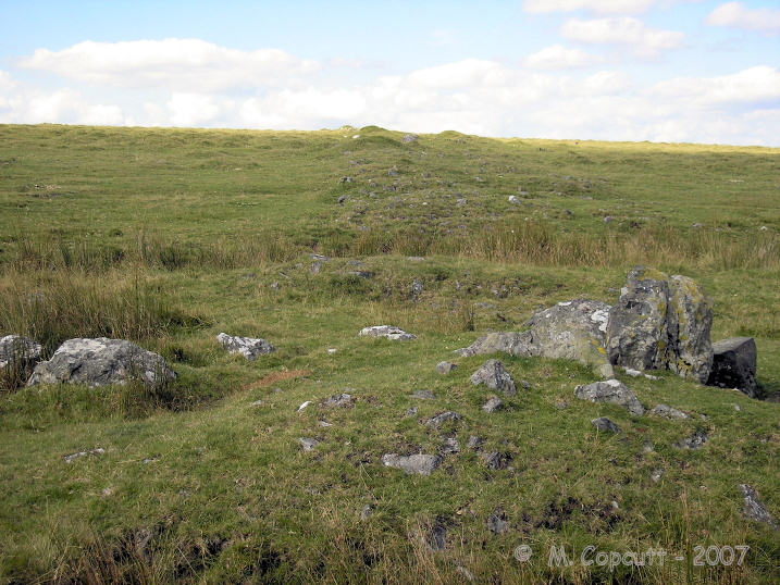
Langstone Moor row 2 submitted by TheCaptain on 18th Sep 2007. There is possibly a cairn to be found at the upper, northern end, and the remains of some sort of structure made with larger stones at a southern position, just about 70 metres from the Langstone.
(View photo, vote or add a comment)
Log Text: None
Langstone Moor circle
Date Added: 18th Sep 2010
Site Type: Stone Circle
Country: England (Devon)
Visited: Yes on 7th Sep 2007

Langstone Moor circle submitted by TheCaptain on 7th Sep 2007. The fractured remains of Langstone Moor stone circle, seen here looking towards the south.
Great Mis Tor on the left, Great Staple Tor in the distance to the right.
(View photo, vote or add a comment)
Log Text: None
Langrais menhirs
Trip No.202 Entry No.12 Date Added: 26th Mar 2020
Site Type: Standing Stones
Country: France (Normandie:Calvados (14))
Visited: Saw from a distance on 23rd Apr 2005
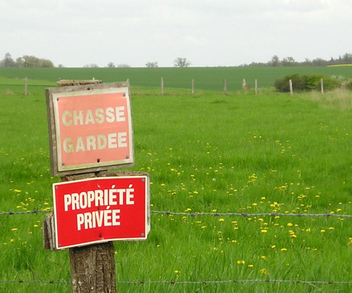
Langrais menhirs submitted by TheCaptain on 6th May 2005. Langrais menhirs, Soumont-Saint-Quentin, Calvados.
2 large menhirs in a field to the east of the village near Mont Joly, but which are 500 metres from the road across a field surrounded by barbed wire and with very clear keep out signs. One of the two menhirs stands 3.6 metres high, while the other is fallen.
The standing menhir can be seen here between the third and fourth fencepost along to the right of the sign.
(View photo, vote or add a comment)
Log Text: Two large menhirs in a field to the east of the village near Mont Joly but which are 500 metres from the road across a field surrounded by barbed wire and with very clear keep out signs. One of the two menhirs stands 3.6 metres high while the other is fallen.
In the region around here are many other large stones some of which may well be fallen menhirs and indeed perhaps a row can be determined in the lane called “Route des Menhirs”.
Langrais menhirs
Trip No.212 Entry No.6 Date Added: 26th Mar 2020
Site Type: Standing Stones
Country: France (Normandie:Calvados (14))
Visited: Yes on 7th May 2012. My rating: Condition 4 Ambience 3 Access 4

Langrais menhirs submitted by Rida on 27th Feb 2011. Site in Normandie:Calvados (14) France
(View photo, vote or add a comment)
Log Text: Having had a good look at the IGN 1:25000 map, I saw that there is a trackway running east from the road south of Mont Joly, which runs from the bottom of the hill diagonally up to the approximate position of the stones. Even better, when arriving there for a look, the trackway was open and easily driveable, and so I took this option on this showery afternoon, and when emerging from below the wood at the top of the hill, there was plenty of space to park amongst a large composting area! Left Dad in the car while I went out into the wind and drizzle to find the stones, and there they were, just round the back of the big pile of manure!
The two stones stand at the edge of an open rocky outcrop at the top of the hill, covered in wildflowers at this time of year, but I learned that the stones are not in their original positions, having been moved there by the farmer at some point in the past. The two stones are very different, the larger stone being a whitish quartz type stone, between 3.5 nd 4 metres tall, while its shorter neighbour is a reddish colour, and only about 1.6 metres tall. There are plently of other large lumps of stone laying about here, which may have been broken from the two menhirs, or just other examples of field clearance.
On the way down from the stones, through a gateway into the wood I could see another rocky outcrop with various large stones standing around, a couple of them probably at least 2 metres tall. This was all now made into a nice garden feature, but is there any ancient significance to the stones? Back onto the road, and I noticed it was called Route des Menhirs, and up towards the top of the hill there was another garden with some large rocks standing in it.
Onto the top of Mont Joly, and it is clear that there are large rocks all over the place, and it is easy to imagine that thee was once an alignement of large stones running along the top of the hill into the ancient settlement. Walking along the edge of the field, and then the pathway to the end of the promontary, and large stones can be seen laying around everywhere, many clearly not just a local outcropping of rock, but various shapes, sizes and types of stone. Many of these rocks were now incorporated into garden features, but many more are just laying there, slowly getting buried by the undergrowth. It really is a fascinating area, and I do wonder what a proper survey of this ancient hilltop would turn up.
Langlade Dolmen
Trip No.203 Entry No.94 Date Added: 6th Apr 2020
Site Type: Burial Chamber or Dolmen
Country: France (Aquitaine:Dordogne (24))
Visited: Couldn't find on 21st May 2005

Langlade dolmen submitted by regina on 21st Jun 2013. Site in Aquitaine:Dordogne (24) France
The dolmen is about 100 m. from the hamlet Langlade under chestnut trees.
coordinate N44.74965 E1.05031(GPS)
(View photo, vote or add a comment)
Log Text: I spent hours looking for this after it looked easy on the 1:25000 map in the supermarket. To start with I was looking on the wrong ridge for a different stone called Cayrelevada. After asking some people logging in a forest they pointed me in the right direction which was several kilometres away ! The book says it’s a beau dolmen beside the road in a garden in the hamlet of Langlade. Try as I might I couldn’t find this. I even looked in the woods around here. I really do need the 1:25000 maps to hunt these things down but at €10 a time for such small areas that’s just not on.
Langcombe Brook 4
Date Added: 29th Oct 2019
Site Type: Cairn
Country: England (Devon)
Visited: Yes on 27th Jul 2006
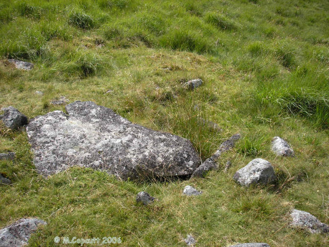
Langcombe Brook 4 submitted by thecaptain on 27th Jul 2006. Langcombe Brook Cairn 4.
Three slabs of the central kist are in place, and a capstone covering half of it is still in place.
(View photo, vote or add a comment)
Log Text: None
Langault Dolmen
Trip No.204 Entry No.287 Date Added: 11th Sep 2020
Site Type: Burial Chamber or Dolmen
Country: France (Centre:Loire-et-Cher (41))
Visited: Yes on 9th Aug 2005. My rating: Condition 4 Ambience 3 Access 5
Langault dolmen submitted by theCaptain on 20th Dec 2011. The dolmen is made from lumps of puddingstone, and the capstone sits on 4 support stones. The entrance, was probably originally to the east, as seen here.
(View photo, vote or add a comment)
Log Text: This is a pleasant little dolmen sat right beside the D.19 road between Cloyes and Morée just after the railway crossing as you travel south, and it has a little parking and picnic area beside it. It’s a pity the road is so busy with big lorries hammering past. The dolmen is made from lumps of puddingstone, and the 3m by 2m capstone sits on 4 support stones, and is open to the south, although this is possibly due to missing stones rather than being a large entrance, which was probably originally to the east.
Landigou Menhir
Trip No.205 Entry No.1 Date Added: 13th Oct 2020
Site Type: Standing Stone (Menhir)
Country: France (Normandie:Orne (61))
Visited: Couldn't find on 29th Aug 2005
Log Text: Looking for this menhir marked on my map, I could find nothing
Lande de Rousse
Trip No.204 Entry No.7 Date Added: 22nd Jun 2020
Site Type: Standing Stones
Country: France (Bretagne:Morbihan (56))
Visited: Yes on 9th Jul 2005. My rating: Condition 2 Ambience 3 Access 4
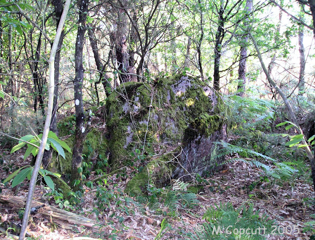
Lande de Rousse submitted by TheCaptain on 2nd Jun 2007. Deep into the forest is what looked to me to be a row of fallen menhirs, with one large rock still protruding from the ground.
It wouldn't surprise me if there was another row here, like some of those at the nearby Pierres Droites, or perhaps something like La Pièce Couverte.
(View photo, vote or add a comment)
Log Text: Beside the track to the Loge Morinais is marked a menhir on the local maps. I had a good look around, and deep into the forest is what looked to me to be a row of fallen menhirs, with one large rock still protruding from the ground. It wouldnt surprise me if there was another row here, like those at the nearby Pierres Droites, or La Pièce Couverte.
Lancy Polissoir
Trip No.204 Entry No.228 Date Added: 4th Sep 2020
Site Type: Polissoir
Country: France (Bourgogne:Yonne (89))
Visited: Yes on 5th Aug 2005. My rating: Condition 2 Ambience 3 Access 4
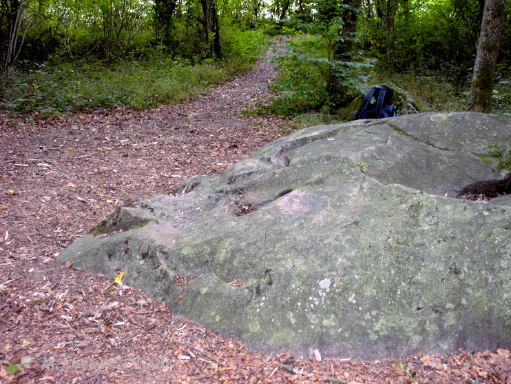
Lancy Polissoir submitted by thecaptain on 20th Jun 2008. As polissoir stones that I have seen go, this is not very impressive. Its a nice stone in the forest, about 2.5m by 2.5 m laying on the ground, with a couple of polishing grooves and a basin which can be determined. The basin is actually very nicely polished.
(View photo, vote or add a comment)
Log Text: About 350 metres to the north of the D.110 road through Lancy Forest can be found this polissoir stone. Park at the Pavillon-de-Lancy picnic site, and the stone can be found down the track along the edge of the forest from there. Luckily it is signposted, as without them I would never have found it.
As polissoir stones that I have seen go, this is not very impressive. Its a nice stone in the forest, about 2.5m by 2.5 m laying on the ground, with a couple of polishing grooves and a basin which can be determined. The basin is actually very nicely polished. This seems a slightly strange place for a polissoir stone, as I can see no natural source for any water nearby, although the stone itself has a large hollow which could have been used as a reservoir. And it is raining !
Lancy Dolmen
Trip No.204 Entry No.227 Date Added: 4th Sep 2020
Site Type: Burial Chamber or Dolmen
Country: France (Bourgogne:Yonne (89))
Visited: Yes on 5th Aug 2005. My rating: Condition 3 Ambience 4 Access 3
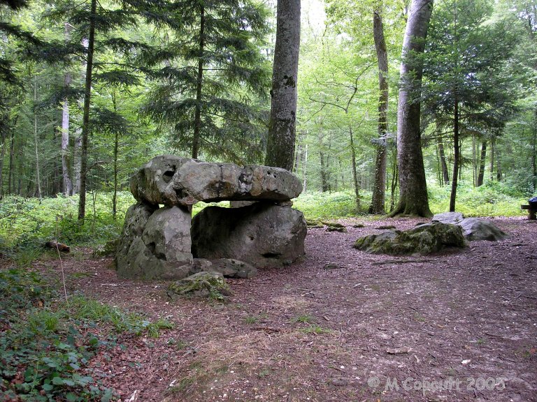
Lancy Dolmen submitted by TheCaptain on 5th Aug 2013. The dolmen is in a little clearing, and easy to find. The first thing you see is the obvious dolmen with capstone on top of two side supports. Closer inspection shows there to be a backstone, and a fallen stone at the large front opening.
(View photo, vote or add a comment)
Log Text: Now this is more like it. In the Foret-de-Lancy, a couple of kilometres to the southeast of Saint-Maurice-aux-Riches-Hommes can be found this nice looking little dolmen. It is signposted from the road through the forest about 700 metres south of the parking place at the track to the Traînel dolmens, and is a 700 metre walk from the road along a forest track.
The dolmen is in a little clearing, 10 metres from the track, and easy to find. The forst thing you see is the obvious dolmen with a 3 m by 2 m capstone sat on top of two side supports, about 1.2 metres off the ground. Closer inspection shows there to be a backstone, and a fallen stone at the large front opening. Just to the southeast is another large stone standing upright, and there are plenty of other large stones laying about nearby. There would appear to be the remains of a round mound within which the dolmen was once covered.
I wonder whether there was a second chamber at some point, or perhaps a circle of stones around the mound. This is a very pleasant spot. Strangely, there are many hand prints painted on some of the stones.
Lanacombe 5
Date Added: 18th Sep 2010
Site Type: Multiple Stone Rows / Avenue
Country: England (Somerset)
Visited: Yes on 5th Aug 2007

Lanacombe 5 submitted by TheCaptain on 5th Aug 2007. On the south facing slopes of Lanacombe Hill on Exmoor, are the remains of this fairly recently found stone setting.
I found many stones and stumps of stones standing proud of the ground.
The book I have says 9 stones in 3 rows, but to be honest, it could be anything.
(View photo, vote or add a comment)
Log Text: None
Lanacombe 4
Date Added: 18th Sep 2010
Site Type: Stone Row / Alignment
Country: England (Somerset)
Visited: Yes on 29th Mar 2007
Lanacombe 4 submitted by thecaptain on 29th Mar 2007. What did I find here ? Absolutely nothing. Not a Sausage. Diddley Squat.
(View photo, vote or add a comment)
Log Text: None
Lanacombe 3
Date Added: 18th Sep 2010
Site Type: Multiple Stone Rows / Avenue
Country: England (Somerset)
Visited: Yes on 31st Jul 2007
Lanacombe 3 submitted by TheCaptain on 31st Jul 2007. The first, and only obvious stone I found here at Lanacombe 3.
(View photo, vote or add a comment)
Log Text: None
Lanacombe 2
Date Added: 18th Sep 2010
Site Type: Stone Row / Alignment
Country: England (Somerset)
Visited: Yes on 17th Aug 2007

Lanacombe 2 submitted by TheCaptain on 17th Aug 2007. The third stone I found, I would estimate to be about 20–30 metres further up the hill, but it is leaning over or fallen, and well hidden in some marsh grass.
(View photo, vote or add a comment)
Log Text: None
Lanacombe 1
Date Added: 18th Sep 2010
Site Type: Multiple Stone Rows / Avenue
Country: England (Somerset)
Visited: Yes on 9th Dec 2007

Lanacombe 1 submitted by thecaptain on 9th Dec 2007. This stone setting is more nearly on the ridgetop of Lanacombe Hill, with super views to the south and east.
Although the views when I was first here were shrouded in mist.
(View photo, vote or add a comment)
Log Text: None
Lakehead Hill W
Date Added: 27th Sep 2020
Site Type: Stone Row / Alignment
Country: England (Devon)
Visited: Yes on 18th Sep 2020. My rating: Condition 3 Ambience 3 Access 3
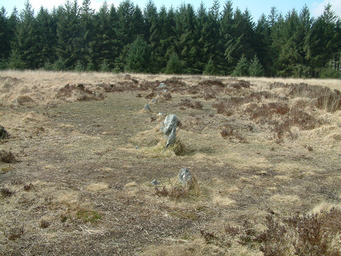
Lakehead Hill W submitted by simonsworn on 3rd Apr 2005. From the eastern end of the row, facing west
(View photo, vote or add a comment)
Log Text: I now head north to the top of the hill, where a single stone row of about a dozen stones heads east to west across the hilltop. There is no obvious cairn, but at the western end the stone is facing across the rline of the row as if to be a Blocking Stone.
Lakehead Hill E
Date Added: 27th Sep 2020
Site Type: Stone Row / Alignment
Country: England (Devon)
Visited: Yes on 18th Sep 2020. My rating: Condition 4 Ambience 4 Access 3
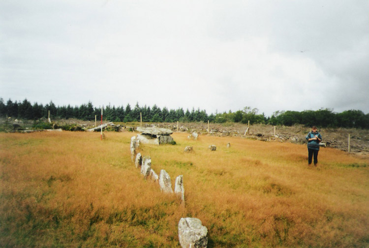
Lakehead Hill E submitted by simonsworn on 15th Mar 2005. After the surrounding plantation was cleared, facing NW, scale at 2m.
(View photo, vote or add a comment)
Log Text: Carry on northwards and then left in the scrubby gap between the forest trees to what the OS mark as "Cairn Circle & Cist". A path leads on westwards and then there it is, the coverstar of the Lakehead Hill sites. A short stone row leads westwards to a large rectangular box structure, all in a very nicely tended open area. I suspect this has all been "restored", but it does look very pretty in the afternoon sunshine. These days eleven stones make the row leading westwards to the cist, with a kink in the middle. The cist is a large box structure, much bigger than most of the cists on Dartmoor, and I think could be considered more of a burial chamber. This is partially surrounded by a circle of half a dozen small stones, although this has probably not been reconstructed very accurately. I like it.
