Contributory members are able to log private notes and comments about each site
Sites theCAptain has logged. View this log as a table or view the most recent logs from everyone
La Maison des Feins
Trip No.208 Entry No.5 Date Added: 13th Jun 2020
Site Type: Passage Grave
Country: France (Bretagne:Ille-et-Vilaine (35))
Visited: Yes on 20th Mar 2008. My rating: Condition 5 Ambience 5 Access 4

La Maison des Feins submitted by thecaptain on 16th Apr 2008. La Maison des Feins is about 12 metres long, but it is not much more than a metre wide or high. Truly a house for the fairies.
My Dad adds scale to the fairies house, viewed here from the southeastern end.
(View photo, vote or add a comment)
Log Text: None
Champ Dolent Menhir
Trip No.208 Entry No.6 Date Added: 13th Jun 2020
Site Type: Standing Stone (Menhir)
Country: France (Bretagne:Ille-et-Vilaine (35))
Visited: Yes on 20th Mar 2008. My rating: Condition 5 Ambience 4 Access 5
Champ Dolent menhir submitted by rw1 on 2nd Mar 2008. 09/2007
(View photo, vote or add a comment)
Log Text: None
Four-És-Feins
Trip No.209 Entry No.10 Date Added: 13th Jun 2020
Site Type: Passage Grave
Country: France (Bretagne:Ille-et-Vilaine (35))
Visited: Yes on 12th Jun 2009. My rating: Condition 2 Ambience 4 Access 3
Four-És-Feins submitted by karolus on 12th Jan 2018. Site in Bretagne:Ille-et-Vilaine (35) France
(View photo, vote or add a comment)
Log Text: I went and had another look for this while in the area last weekend, now knowing to look nearby to the Beillac farm. I could see nothing obvious when driving slowly down the lane past the farm, but there was an old couple out tending their wonderful vegetable garden, so I stopped and asked them if they could tell me where the dolmen was. They were interested to know what an Englishman was doing looking for the remnants of the dolmen, but were happy to help.
Unfortunately, I struggled to understand fully all they were saying, a combination of strong accent and using some words I just could not figure out. But I thought I had got enough of a lead to find it easily. Park out of the way of the farm track by the corner of the farm. Cross the field to the south on the newly cut hay at the edge of the field for 200 metres until reaching the other side. Go straight on about another 100 metres (unknown words) until I get to the big trees, and it is on the left, (some more unknown words). Put boots on if you have them. Sounds simple.
Well, it was all very simple simple, until I tried to decide which of all the woodlands were the correct big trees. However, after a few false starts, I found a place in a woodland to the left of the track, with a mound in it, and what looked to be some lumps sticking up, but it was very overgrown. It has to be this, surely. Closer inspection amongst the ivy and brambles, and there were clearly a few side set slabs sticking up through the ground, and I was pretty sure I could determine two rows of slabs about 1.5 metres apart from each other, but with no stone more than 0.5 metres tall, and most substantially lower. I reckoned that what I had found on top of the mound was about 10 metres in length, and had to be the remains of a very ruined allée couverte.
However, walking back to the car, I thought that these poor remains were not really enough to be known by the name Four-es-Feins; the Fairies Oven. Surely something with a name like that must be a grander structure. I also thought it to be too ruined to be what the old couple were explaining to me, although they did say it was just the remains of an allée couverte. I would have thought they would have told me not to bother rather than gladly give me directions.....
Upon returning to the car, I remembered I had book with description in a box in the boot. "Rectangular chamber measuring 10m by 1.5m with 6 orthostats on the south side and 5 on the north. Their length is between 1 and 1.8 metres, height about half a metre and thickness 0.3 metres. Brilliant, this all fits to what I saw. But then, the description goes on. Three cover slabs about half a metre thick, and the backstone are still in place. Around the monument, a dozen or so other stones lie scattered.
Well, I can believe the stones are now more covered by undergrowth and soil than that description, and hence seem smaller. The size, orientation and almost everything seems right, with one major exception; the three cover stones. There was nothing at all which could have been them. Read the description again and realise it has been based upon a plan and writings from 1886 and 1928. Maybe it has become much more wrecked since then, but what of the old couples talk ?
So, was this Four-es-Feins or not? If it wasn't, what had I found ? I am not sure, but like to think I did find it. Certainly until anyone proves otherwise and can show me something better I'll count it.
Beleven allée couverte
Trip No.209 Entry No.11 Date Added: 13th Jun 2020
Site Type: Passage Grave
Country: France (Bretagne:Côtes-D'Armor (22))
Visited: Yes on 12th Jun 2009. My rating: Condition 3 Ambience 2 Access 4

Beleven allée couverte submitted by thecaptain on 24th Jun 2009. There is even a sign here, but unfortunately while holding my camera above my head to get the picture, I have chopped off the bottom and left side a bit.
Still, it shows a plan and good artistic reconstruction of the place.
(View photo, vote or add a comment)
Log Text: Remains of a fairly disturbed but mostly complete allée couverte can be found in dark woodland to the northwest of the village of Plouer-sur-Rance, to the north of the magnificent ancient city of Dinan. Although the quartz block stones of this 14 metre long allée couverte are fairly well disturbed, it is in fact mostly complete, with a well defined terminal cella, and even with traces of its mound still to be seen. It is possible that it once had a lateral entrance.
Remarkably, it is stated that this monument was only discovered in 1972, which I find hard to believe, and it was classified as a monument historique as recently as 1981.
The poor thing is very close to a busy express highway, the N176, which runs along this northern edge of Brittany, but although the noise from the traffic is constant, the dense woodlands do a good job of hiding it all.
Despite looking on maps as if it would be very difficult to access, its on a wooded hillside right next to the dual carriageway road , there is in fact an emergency phone and layby nearby on the northbound carriageway, where it is possible to park and visit the monument. From the layby, hop over a little fence and follow a well worn path to the left for about 100 metres, and there it is ! Brilliant, its like the layby is deliberately put there for us stonehunters !
Outre Tombes
Trip No.209 Entry No.12 Date Added: 13th Jun 2020
Site Type: Stone Circle
Country: France (Bretagne:Ille-et-Vilaine (35))
Visited: Yes on 12th Jun 2009. My rating: Condition 3 Ambience 3 Access 5

Outre Tombes submitted by thecaptain on 5th Jul 2009. There are several information plaques at the site.
(View photo, vote or add a comment)
Log Text: This horseshoe of megalithic stones has alternatively been considered as a megalithic enclosure (cromlech) or perhaps the stones once surrounding a dolmenic burial chamber. Seven stones are shaped in a sort of semi circle, of diameter about 7 metres.
This monument was classified as a historical monument in 1966, but by 1977 had disappeared, being the victim of an expansion of the local quarry at Vaujour. When this was discovered, the police were called in, but it was all thought to be too late. However, in 1989 it was found that most of the stones hadn't simply been destroyed, but had been moved and dumped into a nearby field, although one had gone through the stonecrusher. With the help of a plan and photograph of the site taken in 1962, the local people (with the help of the quarrying company) had the site recreated in 1998, just a few hundred metres from its original position.
There is also a small menhir erected at the site, the origins of which I do not know, but the stone does not look modern. Today, the site sits in a little meadow near to the top of the quarry, and can be found beside the little road which runs along the top of the hills to the northeast of the massive Vaujour quarries. There are several information plaques at the site, telling of its history and with diagrams and pictures.
La Roche Longue (St-Marcan)
Trip No.209 Entry No.13 Date Added: 13th Jun 2020
Site Type: Standing Stone (Menhir)
Country: France (Bretagne:Ille-et-Vilaine (35))
Visited: Yes on 12th Jun 2009. My rating: Condition 4 Ambience 3 Access 4

La Roche Longue (St-Marcan) submitted by thecaptain on 30th Jun 2009. View of La Roche Longue seen from the west.
(View photo, vote or add a comment)
Log Text: This well shaped menhir is just under 3 metres tall in a field to the east of the St Marcan cemetary. As with my previous visit, the field is planted with maize, and is today sodden wet, which prevents me from being abole to walk right up to the stone. However, this time I can walk up the western edge of the field by the cemetary, and photograph its other side in the afternoon sunshine.
Menhir du Perron (St-Marcan)
Trip No.209 Entry No.14 Date Added: 13th Jun 2020
Site Type: Standing Stone (Menhir)
Country: France (Bretagne:Ille-et-Vilaine (35))
Visited: Yes on 12th Jun 2009. My rating: Condition -1
Log Text: A 2 metre tall menhir similar to the Roche Longue of St Marcan, once stood in the fields of Perron, about 800 metres south of La Roche Longue. It somehow disappeared in the 1930's.
Roche-aux-Fées (Essé)
Trip No.210 Entry No.2 Date Added: 16th Sep 2020
Site Type: Passage Grave
Country: France (Bretagne:Ille-et-Vilaine (35))
Visited: Yes on 3rd Jun 2010. My rating: Condition 5 Ambience 5 Access 5

Roche-aux-Fées (Essé) submitted by AlexHunger on 21st Sep 2004. Roches Aux Fees viewed from North West
(View photo, vote or add a comment)
Log Text: June 2010 visit to France to see my sister, and as usual I had my Dad with me. I had decided on a long detour to visit La Roche-aux-Fées, but before we came here, I had told him nothing about it, except to say we were going to visit somewhere special. He is well used to me taking him to old stones all over the place, often on wild goose chases in woods and across fields finding nothing. But not this time.
This monument is now presented quite differently to when I previously visited in 2005, with a large new car park and visitor centre in what would have been fields to the south. Unfortunately, the visitor centre was closed, being open at weekends and holidays only this time of year until July and August when it becomes daily. I have read that this centre is very good, and with a decent book and gift shop.
From the visitor centre, a pathway leads through a nicely landscaped area towards the monument itself, which is hidden behind trees and hedges, until you round the end of a hedge (with a large fallen stone at the corner), and then there it is, in all its splendor, viewed towards the wonderful portal entrance. Even on my second visit here, it is awe inspiring, especially the work on the portico, which is over 4500 years old and still completely level.
My Dad was well impressed too, and couldn’t quite believe what he was seeing. “Oh My!, How can this be so big? What’s this for?” he asked. “It can’t be just to bury somebody in. All these separate room bits? Why? It’s a bit like the side chapels in a Cathedral”. Pretty much my thoughts exactly, and it is good to hear these things coming from somebody else with no prompting.
Somebody had made little piles of pebbles and other decorative bits and pieces placed at various places, which looked good. I am impressed by one of the massive capstones which seems to have been fitted exactly into a gap in the supporting side stones. This place is truly absolutely fantastic. I don’t have the words for it.
The new field around the monument has been splendidly done, and gives it the space it needs. Only two other people came to visit in the time we were here, a large improvement over my previous August Saturday visit. One downside are the various noticeboards now erected here, stating that cracks have been found in some of the stones, and people should be careful and not climb on the stones. I hope that there is no bad damage to the place. What would the Fairies think?
St-Benoit polissoir
Trip No.210 Entry No.5 Date Added: 13th Jun 2020
Site Type: Polissoir
Country: France (Normandie:Manche (50))
Visited: Yes on 3rd Jun 2010. My rating: Condition 4 Ambience 4 Access 5
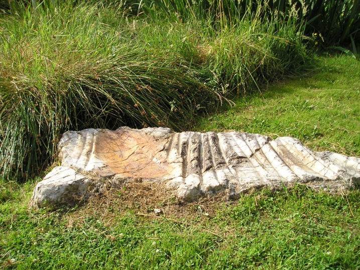
St-Benoit polissoir submitted by thecaptain on 14th Oct 2005. St Benoit polissoir, near St James.
Not a million miles from Mont St Michel, this lovely polissoir stone is nowadays nicely kept in a little garden type area beside the lane.
(View photo, vote or add a comment)
Log Text: Decide to take Dad here to see this special stone, so leave the autoroute at St James, to go have a look – the third time I will have tried to take Dad here, having missed it twice before due to roadworks and a shut bridge, and lateness on the previous occasions. Blimey, there are now big brown signs indicating it from the main road.
Set in its nice little marshy area, this is now very well looked after and presented, unlike the old description when I was first looking for it several years ago. The stone is a bit smaller than I remember it, but it is really wonderful. I just love being able to sit and stroke the very polished grooves, and let my mind wander back through the millennia. Again, Dad seemed well impressed at being able to see something like this.
La Loge aux Sarrasins
Trip No.211 Entry No.4 Date Added: 26th Mar 2020
Site Type: Burial Chamber or Dolmen
Country: France (Normandie:Calvados (14))
Visited: Yes on 9th Oct 2011. My rating: Condition 4 Ambience 3 Access 4
la Loge aux Sarrasins submitted by hrun95 on 21st Jun 2011. These photos were taken in 2007, in the garden of the owners. So it's a bit boring because you are in their propriety. I get there by the little path coming by la Chaudronniere.
Site in Normandie:Calvados (14) France
(View photo, vote or add a comment)
Log Text: Having gone to Vire for a Vide Grenier and country show, persuaded Trevor and Sara to visit this stone for another look. Followed the same path as last time, and this time, once at the corner of the garden, the dolmen was clear to be seen in the back garden. At Last!
Its a lovely looking little dolmen. I can only assume that last visit there was a shed in the way, preventing it being seen. To get a better view, went back to the cornfield, and walked along its edge and up along outside the garden. I noticed that a bit further to the west, behind the garage, there was a separate standing stone, a couple of metres tall.
Langrais menhirs
Trip No.212 Entry No.6 Date Added: 26th Mar 2020
Site Type: Standing Stones
Country: France (Normandie:Calvados (14))
Visited: Yes on 7th May 2012. My rating: Condition 4 Ambience 3 Access 4

Langrais menhirs submitted by Rida on 27th Feb 2011. Site in Normandie:Calvados (14) France
(View photo, vote or add a comment)
Log Text: Having had a good look at the IGN 1:25000 map, I saw that there is a trackway running east from the road south of Mont Joly, which runs from the bottom of the hill diagonally up to the approximate position of the stones. Even better, when arriving there for a look, the trackway was open and easily driveable, and so I took this option on this showery afternoon, and when emerging from below the wood at the top of the hill, there was plenty of space to park amongst a large composting area! Left Dad in the car while I went out into the wind and drizzle to find the stones, and there they were, just round the back of the big pile of manure!
The two stones stand at the edge of an open rocky outcrop at the top of the hill, covered in wildflowers at this time of year, but I learned that the stones are not in their original positions, having been moved there by the farmer at some point in the past. The two stones are very different, the larger stone being a whitish quartz type stone, between 3.5 nd 4 metres tall, while its shorter neighbour is a reddish colour, and only about 1.6 metres tall. There are plently of other large lumps of stone laying about here, which may have been broken from the two menhirs, or just other examples of field clearance.
On the way down from the stones, through a gateway into the wood I could see another rocky outcrop with various large stones standing around, a couple of them probably at least 2 metres tall. This was all now made into a nice garden feature, but is there any ancient significance to the stones? Back onto the road, and I noticed it was called Route des Menhirs, and up towards the top of the hill there was another garden with some large rocks standing in it.
Onto the top of Mont Joly, and it is clear that there are large rocks all over the place, and it is easy to imagine that thee was once an alignement of large stones running along the top of the hill into the ancient settlement. Walking along the edge of the field, and then the pathway to the end of the promontary, and large stones can be seen laying around everywhere, many clearly not just a local outcropping of rock, but various shapes, sizes and types of stone. Many of these rocks were now incorporated into garden features, but many more are just laying there, slowly getting buried by the undergrowth. It really is a fascinating area, and I do wonder what a proper survey of this ancient hilltop would turn up.
Mont Joly
Trip No.212 Entry No.8 Date Added: 26th Mar 2020
Site Type: Ancient Village or Settlement
Country: France (Normandie:Calvados (14))
Visited: Yes on 7th May 2012. My rating: Condition 2 Ambience 4 Access 5
Mont Joly submitted by theCaptain on 15th Jan 2014. This promontory site is surrounded on three sides by the steep gorge of the river Laizon, and the eastern end has been defended by ramparts, a little of which can now be seen between the church and water tower.
In this picture a raise in the land can be seen to the left of my Dad.
(View photo, vote or add a comment)
Log Text: What an intriguing place this is, and deserving of much more thorough exploration.
Mont St Michel
Trip No.212 Entry No.13 Date Added: 13th Jun 2020
Site Type: Ancient Village or Settlement
Country: France (Normandie:Manche (50))
Visited: Yes on 11th Oct 2012. My rating: Condition 5 Ambience 4 Access 4
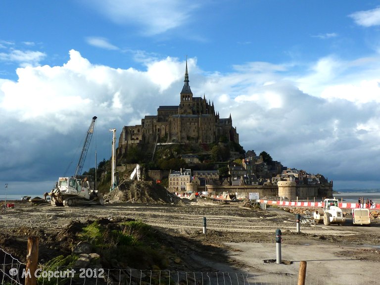
Mont St Michel submitted by theCaptain on 4th Jan 2013. They are trying to cut off the Mont again, to get the sea to surround it once more, and this involves removing the old causeway which prevented the tide clearing the silts etc, and just have a bridge going out to the Mont. This and alterations to the river should then mean the silts get washed away, and the sea once more claims the Mont at each high tide.
(View photo, vote or add a comment)
Log Text: Getting a late lunch at Plein Fougeres, it is now much too late to go to Fougeres and have a proper look round, so we decide to go to Mont St Michel for a quick look around. Shouldn't be too busy at this time of year. It has all changed since either myself or Dad was last there, and you now have to park miles away, at what is becoming a sort of holiday village resort. Many huge car parks, some hotels and restaurants etc, and a 40 min walk to the Mont, but free shuttle busses are provided. At this point I was ready to give up and drive away, but Dad still wanted to persevere, so we got the shuttle bus 10 mins out to the Mont.
Theres a hell of a lot of work going on here, both to the walls and the surroundings. Turns out they are trying to cut off the Mont again, to get the sea to surround it once more, and this involves removing the old causeway etc, and just have a sort of bridge going out to the Mont. This and alterations to the river should then mean the silts get washed away, and the sea once more claims the Mont at each high tide. I read at the new controlling dam on the river that the land has risen 4.9 metres since the 1960s. Much of these new grassy marshes is being dug up and pushed into the river, hopefully to get washed away.
The place is not too crowded, although many Japanese here, so we walk up to the abbey along the main street, no time to do the tour. Walk down around the outer walls, watching the tide coming in, and theres a group of people out walking over the sands and mud with the water coming in. Just as we leave the Mont, the sun starts to come out, making a few pictures much better.
Cup of tea, then on to Sara's, much later than we ought to be, but this time its not all my doing! Must visit here properly sometime, October Thursday mornings might be OK, but need the whole day.
Le Wuy Menhir
Trip No.212 Entry No.17 Date Added: 30th Mar 2020
Site Type: Standing Stone (Menhir)
Country: France (Normandie:Seine-Maritime (76))
Visited: Yes on 27th Dec 2012. My rating: Condition 3 Ambience 3 Access 5
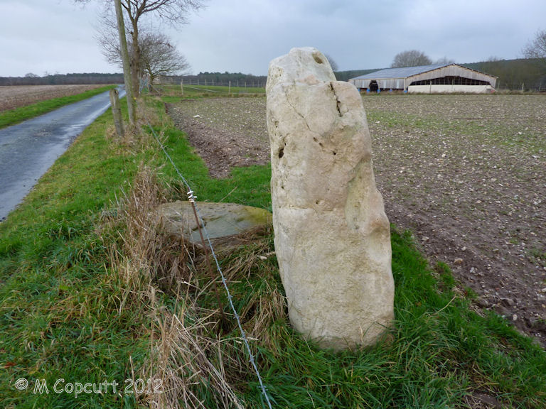
Le Wuy Menhir submitted by theCaptain on 1st Jan 2014. Described as a menhir, this site is more likely the remains of a burial chamber of some sort, which has been largely destroyed by agriculture.
(View photo, vote or add a comment)
Log Text: Described as a menhir, this site is the remains of a burial chamber of some sorts, which has been largely destroyed by agriculture. The remains I found consist of one large standing stone, about 2 m width and just over a metre in height. Its a lovely slab of sarsen like stone, which is all smooth on the southern face, but all lumpy and holed on the northern face, as sarsen often is. Beside this stone is another slab of sarsen flat to the ground.
I am sure this is not a menhir as described, but a remaining slab from a burial chamber of some sort, whether a side slab or end slab is not clear. It is possible that this stone is not in its original position, but has been moved here to help clear the fields for ploughing.
Pierre Trouée de l'allée couverte d'Aizier
Trip No.212 Entry No.18 Date Added: 30th Mar 2020
Site Type: Passage Grave
Country: France (Normandie:Eure (27))
Visited: Yes on 27th Dec 2012. My rating: Condition 4 Ambience 4 Access 5
Pierre Trouée de l'allée couverte d'Aizier submitted by theCaptain on 30th Dec 2012. This wonderful holed stone is today found nicely presented just outside the little church of the village of Aizier, right on the banks of the River Seine. The stone is the portholed entry stone from a now destroyed allée couverte, destroyed during the making of a road.
The stone is about 1.7 metres tall and wide, thickness 22 cm, but the important dimension is that of the circular hole, which is diameter 47 cm, and yes, I did manage to crawl through it!
(View photo, vote or add a comment)
Log Text: This wonderful holed stone is today found nicely presented (since 1976) just outside the little church of the village of Aizier, right on the banks of the River Seine not too far upstream from the Tancarville Bridge, a few miles inland from Le Havre.
The stone is the remains of the portholed entry stone from a now destroyed allée couverte, which was destroyed during the making of the road to Bourneville sometime in the 19th century. The stone is about 1.7 metres tall and wide, with thickness 22 cm, but the important dimension is that of the circular hole, which is of diameter 47 cm, and yes, I did manage to crawl through it!
This type of allée couverte was fairly common in this region, and dates to the final neolithic, -3500 BC to -2800 BC.
Grand menhir de Saint-Eden
Trip No.214 Entry No.1 Date Added: 28th May 2020
Site Type: Standing Stone (Menhir)
Country: France (Bretagne:Finistère (29))
Visited: Yes on 16th Apr 2014. My rating: Condition 3 Ambience 4 Access 4
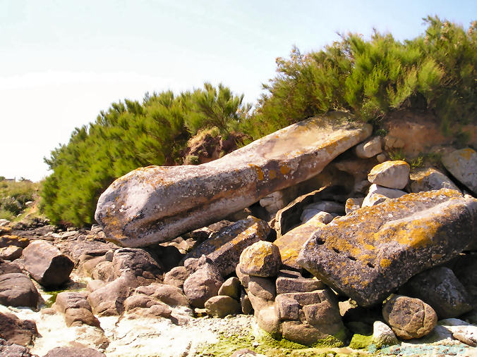
Grand menhir de Saint-Eden submitted by thecaptain on 20th May 2006. Fallen at the edge of the sea is the almost forgotten St Eden grand menhir.
About 8 metres in length, weathering from the thousands of years it was standing can be seen as the rain channel down its side.
(View photo, vote or add a comment)
Log Text: Splendid fallen menhir, right at the edge of the sea, and bigger than I recall it. Now got some pictures with Dad in it for scale. Dad thought it looked like it had a snake or serpent head
Guinivrit
Trip No.214 Entry No.2 Date Added: 28th May 2020
Site Type: Passage Grave
Country: France (Bretagne:Finistère (29))
Visited: Saw from a distance on 16th Apr 2014
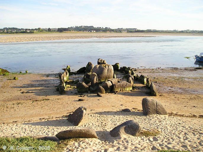
Guinivrit submitted by thecaptain on 25th Mar 2006. Guinivrit allée couverte.
The remains of this allée couverte clearly show the rise in sea level over the past 4000 odd years. Twice a day it gets a wash.
(View photo, vote or add a comment)
Log Text: Seen from over the estuary from the south, tide out and on the sandy beach.
Diévet Dolmen
Trip No.214 Entry No.3 Date Added: 23rd Jul 2020
Site Type: Burial Chamber or Dolmen
Country: France (Bretagne:Finistère (29))
Visited: Yes on 16th Apr 2014. My rating: Condition 4 Ambience 3 Access 4
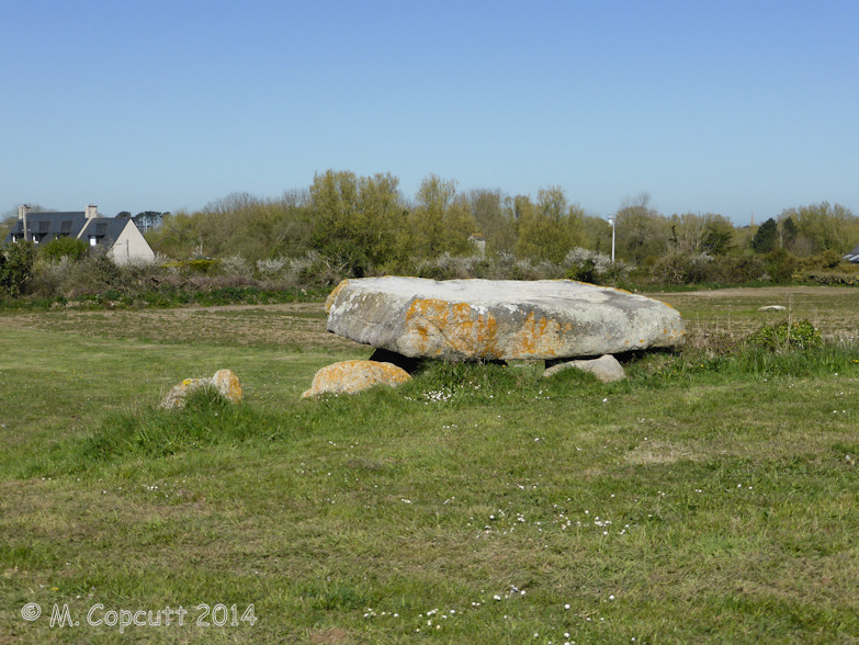
Diévet dolmen submitted by theCaptain on 29th Jun 2014. Now completely surrounded by cultivated fields, the remains of this allée couvert are easily found to the west of the hamlet of Diévet.
Site in Bretagne:Finistère (29) France
(View photo, vote or add a comment)
Log Text: Now completely surrounded by cultivated fields, the remains of this allée couvert are easily found to the west of the hamlet of Diévet. What remains are two parallel rows of orthostats (12 in total), between 10 and 11 metres in length by 1.5 metres wide, and with a single large coverstone remaining in the middle.
Menoignon menhir
Trip No.214 Entry No.4 Date Added: 23rd Jul 2020
Site Type: Standing Stone (Menhir)
Country: France (Bretagne:Finistère (29))
Visited: Yes on 16th Apr 2014. My rating: Condition 4 Ambience 4 Access 5
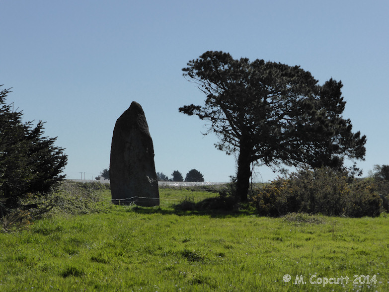
Menoignon menhir submitted by theCaptain on 5th May 2014. Absolutely splendid menhir which is easily found near to a corner in a little open farmland lane, just behind a little scrubland area.
(View photo, vote or add a comment)
Log Text: Absolutely splendid menhir which is easily found near to a corner in a little open farmland lane, just behind a little scrubland area. The menhir must be about 8 metres in height, of large girth at the bottom, slowly tapering up to a pointed top. The southeastern face of the menhir has been worked into an extremely flat surface, of triangular shape, something which clearly took a lot of time to produce. One can only speculate at what this was used for, I have no doubt that it may well have been painted on.
The locality of the stone is a bit marshy, and perhaps there is a spring nearby, underneath some of the wooded glades. Not far away to the east (~20 metres) is another large stone, which looks fairly natural, but I have no doubt it has some relation to the menhir.
Men-Marz
Trip No.214 Entry No.5 Date Added: 28th May 2020
Site Type: Standing Stone (Menhir)
Country: France (Bretagne:Finistère (29))
Visited: Yes on 16th Apr 2014. My rating: Condition 5 Ambience 4 Access 5

Men-Marz menhir submitted by thecaptain on 3rd Jul 2005. Men-Marz, the Miracle Stone, 8.5 metres tall, near Brignogan Plage in Brittany.
Photograph taken about 6:15 pm June 21 2005, summer solstice.
Cat * A *
(View photo, vote or add a comment)
Log Text: Had to bring Dad to see this fantastic menhir which is found to the north of Brignogan-Plage village and found by following plentiful signs. Men-Marz is set in a nice little area which has an information centre across the road with lots of informative boards.
At more than 8.5 metres high it is said to be the fourth largest menhir still standing in France. It is a strange shaped beast as are the natural rocks around here and looks to be a thin and straight beast when seen from front and back but is a sort of triangular shape when seen from the sides with multiple cavities and ledges in the sides.
The stone has suffered from Christianising vandalism on at least two occasions as it not only has a granite cross mounted on the top but there is also an engraved cross on the south-eastern corner about 1.5 metres from the ground. This stone has many legends attached to it which seem to get a bit mixed up and confused. There is a ledge high up on the south side which today had a lot of loose stones on it, attached to which are legends concerning marriage or childbirth. Both myself and Dad failed to land our stones on the ledge!
