Contributory members are able to log private notes and comments about each site
Sites theCAptain has logged. View this log as a table or view the most recent logs from everyone
Créac'h Gallic
Trip No.203 Entry No.528 Date Added: 28th May 2020
Site Type: Passage Grave
Country: France (Bretagne:Finistère (29))
Visited: Yes on 21st Jun 2005. My rating: Condition 4 Ambience 3 Access 5
Créac'h Gallic submitted by TheCaptain on 17th Apr 2011. Here are the remains of a fairly large megalithic structure, but it looks to be in a bit of a precarious state. Warning signs and a fence warn of climbing on or near to the stones.
(View photo, vote or add a comment)
Log Text: Here are the remains of a fairly large dolmen, but it looks to be in a bit of a precarious state. Warning signs and a fence warn of climbing on or near to the stones. The basic chamber is about 4 metres by 2 metres and 2 metres high, with a single capstone resting (just) on three support stones. It looks like a fourth support has recently broken and fallen, and it looks most precarious and that it could fall at any time.
Strangely there are many large slabs around the outside, making a sort of wall, I cannot really make this out at all. Seems it was once a large allée couverte with a peristalith surrounding its mound, some of which still survives. But its a bit difficult to fully make out and understand, and has no doubt been damaged in the past with the construction of the farms and the lanes.
There are many other large stones laying around, I need to try and look this one up. Now I know what it is, it seems obvious what the remains are.
Guinivrit
Trip No.203 Entry No.529 Date Added: 28th May 2020
Site Type: Passage Grave
Country: France (Bretagne:Finistère (29))
Visited: Yes on 21st Jun 2005. My rating: Condition 3 Ambience 4 Access 4
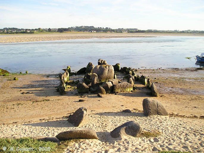
Guinivrit submitted by thecaptain on 25th Mar 2006. Guinivrit allée couverte.
The remains of this allée couverte clearly show the rise in sea level over the past 4000 odd years. Twice a day it gets a wash.
(View photo, vote or add a comment)
Log Text: This really is a nice place to visit, certainly when its quiet and the sun is out. I had hoped to see it with the tide well in tonight, but one thing and another and its now gone 8:00, and the tide is already gone out for two hours, and the water has gone from around it. However, there is still a lot of water flooding out of the bay, and I certainly wouldn't want to try and get a boat in here, as its going at running speed.
The allée couverte is easily found down beside the little harbour, and nowadays is signposted. Its not far at all from the little campsite where I stayed. Despite the fact that it has no capstones, and that some of the large side stones have been broken so it could act as a mole in the water for mooring and protecting boats in the past, it really is surprisingly complete. Most of the stones are still in place, not only of the main chamber, but also the peristalith, which is suitably boat shaped. In fact the whole thing looks rather like a boat pulled up onto the shoreline.
The main chamber is about eleven metres long and 1.5 metres in width, but with the outer stones the full size of the monument is more than double that, perhaps 30 metres by 6 metres. There is both a forward and aft extension to the compartmentalised chamber. Fantastic.
While here, I met a chap out for a bike ride, and we got talking about why I was here and ancient stones. He said he has always lived in the area, and as a boy used to play in the Goazvenn dolmen. He went on to tell me about a large fallen menhir that is almost forgotten, and that nobody ever talks about, and which seems to be in no historical records. He told me how to find it by walking around the coast path, and showed me where it was on my map, fallen onto the rocky shore. I decided that this was one place I had to visit, finding these forgotten stones has much more of a thrill than seeing the well known ones.
Guinivrit
Trip No.214 Entry No.2 Date Added: 28th May 2020
Site Type: Passage Grave
Country: France (Bretagne:Finistère (29))
Visited: Saw from a distance on 16th Apr 2014

Guinivrit submitted by thecaptain on 25th Mar 2006. Guinivrit allée couverte.
The remains of this allée couverte clearly show the rise in sea level over the past 4000 odd years. Twice a day it gets a wash.
(View photo, vote or add a comment)
Log Text: Seen from over the estuary from the south, tide out and on the sandy beach.
Grand menhir de Saint-Eden
Trip No.214 Entry No.1 Date Added: 28th May 2020
Site Type: Standing Stone (Menhir)
Country: France (Bretagne:Finistère (29))
Visited: Yes on 16th Apr 2014. My rating: Condition 3 Ambience 4 Access 4
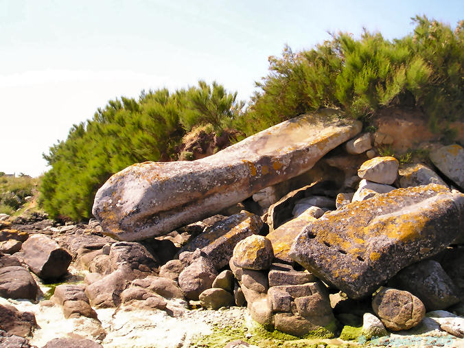
Grand menhir de Saint-Eden submitted by thecaptain on 20th May 2006. Fallen at the edge of the sea is the almost forgotten St Eden grand menhir.
About 8 metres in length, weathering from the thousands of years it was standing can be seen as the rain channel down its side.
(View photo, vote or add a comment)
Log Text: Splendid fallen menhir, right at the edge of the sea, and bigger than I recall it. Now got some pictures with Dad in it for scale. Dad thought it looked like it had a snake or serpent head
Grand menhir de Saint-Eden
Trip No.203 Entry No.532 Date Added: 28th May 2020
Site Type: Standing Stone (Menhir)
Country: France (Bretagne:Finistère (29))
Visited: Yes on 22nd Jun 2005. My rating: Condition 2 Ambience 3 Access 3
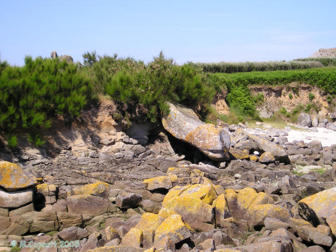
Grand menhir de Saint-Eden submitted by thecaptain on 20th May 2006. Laying fallen at the edge of the sea is the almost forgotten St Eden grand menhir.
(View photo, vote or add a comment)
Log Text: This is the menhir that the chap I met last night was telling me about, right at the edge of the Grève (rocky shore), and unfortunately the sea has claimed it. It is now fallen and laying top down into the sea when the tide is in. Perhaps its one of those menhirs that came down to the sea to drink at midnight, had too much and didnt make it back. Or perhaps came down one night when the tide was not a big one, and fell over while trying to quench its thirst. Whatever, its a great pleasure to find this almost forgotten stone which is not marked on any map.
The stone is a lovely top heavy shape, some would say phallic, and about 8 metres in length. Its a pity it cant be re-erected somewhere, although obviously not in its original cliff edge position. There was an old farmer chap working in some fields nearby who told me that he could remember it standing, but he had no idea when it fell, but it was a long time ago. Fantastic.
Prat Meur menhir
Trip No.203 Entry No.530 Date Added: 29th May 2020
Site Type: Standing Stone (Menhir)
Country: France (Bretagne:Finistère (29))
Visited: Yes on 22nd Jun 2005. My rating: Condition 3 Ambience 3 Access 4
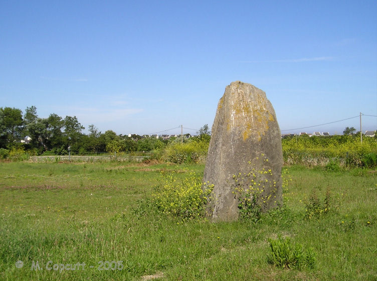
Prat Meur menhir submitted by thecaptain on 24th Jan 2009. This is a pleasant enough menhir, stood in a field beside a trackway at the end of the lane from the port to Prat Meur hamlet.
(View photo, vote or add a comment)
Log Text: This is a pleasant enough menhir, probably 2.8 metres tall and nearly as wide, but less than a metre thick. It is stood in a field beside a trackway at the end of the lane from the port to Prat Meur hamlet. It is nicely weathered at the top.
Somebodies air force is out and about, looks like F.16s so it isn't the French. Probably on holiday at Landivisiau. Suddenly there's a commotion, and a dog barking. A large rabbit or hare flashes past me about 5 metres away, with a dog hotly in chase about 15 metres behind. The rabbit is across a field of artichokes and into a hedge before the dog, and it all goes quiet, before a man is out and whistling to the dog. An interesting little episode.
Porz Ar Stréat menhir
Trip No.203 Entry No.531 Date Added: 29th May 2020
Site Type: Standing Stone (Menhir)
Country: France (Bretagne:Finistère (29))
Visited: Yes on 22nd Jun 2005. My rating: Condition 4 Ambience 3 Access 4

Porz Ar Stréat menhir submitted by thecaptain on 24th Jan 2009. This is a nice menhir in a field not far from the harbour, only a couple of hundred metres from the main village centre.
(View photo, vote or add a comment)
Log Text: This is a nice menhir in a field not far from the harbour, only a couple of hundred metres from the main village centre. Its over 4 metres high and a sort of square section, but tapered at the top, and it has a nice lean.
I cant get right up to it for details though, and its a pity about all the refrigerated lorries at the fish plant nearby making a racket, and a very smelly farmyard.
Menhir de Kergoarat
Trip No.203 Entry No.533 Date Added: 29th May 2020
Site Type: Standing Stone (Menhir)
Country: France (Bretagne:Finistère (29))
Visited: Yes on 22nd Jun 2005. My rating: Condition 5 Ambience 5 Access 4
Menhir de Kergoarat submitted by thecaptain on 1st Dec 2006. Splendidly shaped 7 metres tall menhir standing on its little headland beyond the Cam Louis beach.
As with most of the stones round here, it is a wonderfully weathered rock.
(View photo, vote or add a comment)
Log Text: In contrast to its bulbous headed, thirsty neighbour, this fine chap looks to be wearing a pointy hat. He must be a good 7 metres tall and standing perfectly upright on this little headland beyond the beach. As with most of the stones round here, it is a wonderfully weathered rock, and from certain angles it has a face in it, looking out over the sea.
Menhir d'Irvit
Trip No.203 Entry No.534 Date Added: 29th May 2020
Site Type: Standing Stone (Menhir)
Country: France (Bretagne:Finistère (29))
Visited: Yes on 22nd Jun 2005. My rating: Condition 3 Ambience 3 Access 4
Menhir d'Irvit submitted by TheCaptain on 15th Apr 2011. Just below 4 metres tall, this tapered menhir has a sort of hook at the top of it. Perhaps it is intended as a washing line post! It looks to me, by the patterns in the lichen, that it had a sign attached to it for many years.
(View photo, vote or add a comment)
Log Text: Just below 4 metres tall, this tapered menhir has a sort of hook at the top of it. Perhaps it is intended as a washing line post! It looks to me, by the patterns in the lichen, that it had a sign attached to it for many years. It can be found down a track into a field just east of the D.330 road south of Poulfoen.
Créac’h-ar-Vrenn
Trip No.203 Entry No.535 Date Added: 29th May 2020
Site Type: Passage Grave
Country: France (Bretagne:Finistère (29))
Visited: Yes on 22nd Jun 2005. My rating: Condition 3 Ambience 3 Access 4

Créac’h-ar-Vrenn submitted by thecaptain on 22nd Jan 2009. What I found in 2005, behind the house at the top of the hill beside the water tower, was two rounded looking granite blocks.
With all the fences and undergrowth it was impossible to see if the stones were resting on any kind of supports, but these stones are certainly in the right position for where it is marked on the map.
(View photo, vote or add a comment)
Log Text: I am not 100% sure that I found this. What I possibly found is just some natural rocks. I looked all over the place and asked a couple of people, who both pointed me in the other direction away from their house towards the others. Despite signposts to it down the same lane as the menhir, there was no further evidence for it down there, but the new house being built is probably where the path went.
What I did find, behind the house at the top of the hill beside the water tower, was two rounded looking granite blocks, but it is possible that they have been placed there. With all the fences and undergrowth it was impossible to see if the stones were resting on any kind of supports, but these stones are certainly in the right position for where it is marked on the map.
Couinandré Menhir
Trip No.203 Entry No.536 Date Added: 29th May 2020
Site Type: Standing Stone (Menhir)
Country: France (Bretagne:Finistère (29))
Visited: Yes on 22nd Jun 2005. My rating: Condition 3 Ambience 3 Access 4
Couinandré menhir submitted by TheCaptain on 14th Apr 2011. This is a nicely curved menhir just down a little track and signposted east of Plouescat. Its about 4 metres tall, but in a strange position, not on top of the hill or by the stream.
(View photo, vote or add a comment)
Log Text: This is a nicely curved menhir just down a little track and signposted east of Plouescat. Its about 4 metres tall, but in a strange position, not on top of the hill or by the stream. Despite a little area set aside for it to live in, its getting very overgrown.
Kerider stèle
Trip No.203 Entry No.537 Date Added: 29th May 2020
Site Type: Standing Stone (Menhir)
Country: France (Bretagne:Finistère (29))
Visited: Yes on 22nd Jun 2005. My rating: Condition 3 Ambience 3 Access 4
Kerider stèle submitted by theCaptain on 22nd Jun 2012. This octagonal section tapered Iron Age stèle can be found near the hamlet of Kerider, a few kilometres to the east of Plouescat.
(View photo, vote or add a comment)
Log Text: This is a nice tapered Iron Age stèle which can be found near the hamlet of Kerider, a few kilometres to the east of Plouescat. It is easy to find, just to the north of the D.10 road to St Pol-de-Léon near to the roundabout. It is about 2 metres tall, and nicely octagonal in section.
Kerivin Dolmen
Trip No.203 Entry No.538 Date Added: 29th May 2020
Site Type: Burial Chamber or Dolmen
Country: France (Bretagne:Finistère (29))
Visited: Yes on 22nd Jun 2005. My rating: Condition 3 Ambience 2 Access 4
Kerivin dolmen submitted by TheCaptain on 22nd Jun 2011. This Tee shaped allee couverte is supposedly a very good example of the type, but in June 2005it had become very overgrown.
(View photo, vote or add a comment)
Log Text: Not far off the busy road between Morlaix and Roscoff, this Tee shaped allee couvetre is becoming very overgrown, and its difficult to make anything out at all now. It is also not far from a field corner where people have decided to dumpstuff, so overall its not a winner. I seem to remember this from about 10 years ago as being a good and interesting place to visit.
Kerivin Dolmen
Trip No.187 Entry No.92 Date Added: 29th May 2020
Site Type: Burial Chamber or Dolmen
Country: France (Bretagne:Finistère (29))
Visited: Yes on 11th Sep 1987. My rating: Condition 4 Ambience 3 Access 4
Kerivin dolmen submitted by TheCaptain on 22nd Jun 2011. This Tee shaped allee couverte is supposedly a very good example of the type, but in June 2005it had become very overgrown.
(View photo, vote or add a comment)
Log Text: Cycling camping trip round Brittany day 12. Cycle from Huelgoat, across the Monts Arrée in the pouring rain to St Pol de Leon
Kerivin Dolmen
Trip No.216 Entry No.1 Date Added: 29th May 2020
Site Type: Burial Chamber or Dolmen
Country: France (Bretagne:Finistère (29))
Visited: Yes on 28th Jun 2016. My rating: Condition 3 Ambience 2 Access 4
Kerivin dolmen submitted by TheCaptain on 22nd Jun 2011. This Tee shaped allee couverte is supposedly a very good example of the type, but in June 2005it had become very overgrown.
(View photo, vote or add a comment)
Log Text: Not far off the busy road between Morlaix and Roscoff, this Tee shaped allee couvetre is becoming very overgrown, and its difficult to make anything out at all now. It is also not far from a field corner where people have decided to dumpstuff, so overall its not a winner. I seem to remember this from many years ago as being a good and interesting place to visit.
Barnenez Cairn
Trip No.203 Entry No.539 Date Added: 29th May 2020
Site Type: Chambered Cairn
Country: France (Bretagne:Finistère (29))
Visited: Yes on 22nd Jun 2005. My rating: Condition 5 Ambience 3 Access 4

Barnenez Cairn submitted by thecaptain on 17th Oct 2004. Barnenez Cairn.
View of the quarried away bit of the northwestern side, showing the remains of one of the central chambers.
When the workmen found these internal structures in 1955, the thankfully stopped taking the stone away to make roads, and we are thankfully left with the majority of this wonderful tomb still here after 6500 years.
(View photo, vote or add a comment)
Log Text: This magnificent large cairn, is now signposted from miles around as Le Grand Cairn (de Barnenez). It costs €4.60 to get in, and there is a little visitor centre and shop, with replicas of some of the carved stones on display. Unlike 12 years ago, or whenever, you cannot go into many of the chambers, which are now walled off fairly crudely and unimaginatively, which I think really spoils the place. Its not just that you cant get in, but the way its been done really detracts from the view of the cairn and all its many entrances.
Only two chambers and passages are now open, these being the two beehive construction open chambers, but these seem to be cracking and breaking up. I was told by the man in the centre that they are not, and that they have been like that since their discovery. Perhaps its my memory, but I wonder if the 1960s restoration work is not lasting anywhere near so long as the original 6,000 year old work!
It's still a mighty impressive and imposing tomb sitting on top of its headland, and I think that more land has been cleared around it, allowing much better views over the Bay of Morlaix on one side, and Anse de Terenez on the other, which during this visit were full with a high tide, making the whole place seem truly wonderful.
I got talking to the men in the shop, and they were interested to hear about what I was doing, and one of the guys suggested a couple of places that I shouldn't miss. Commana allee couverte near Roche Trevezel, and Chapelle des Sept Saints near Lannion - a chapel built on top of a dolmen, which can still be seen.
Barnenez Cairn
Trip No.214 Entry No.12 Date Added: 29th May 2020
Site Type: Chambered Cairn
Country: France (Bretagne:Finistère (29))
Visited: Yes on 16th Apr 2014. My rating: Condition 4 Ambience 4 Access 4

Barnenez Cairn submitted by neolithique02 on 22nd Feb 2014. Cairn de Barnenez Site in Bretagne:Finistère (29) France
Image copyright: Néolithique02, hosted on Flickr and displayed under the terms of their API.
(View photo, vote or add a comment)
Log Text: After our visit to Ile Carn, we really had to pay a visit to this, to show Dad the sanitised version of one of these big Brittany Cairns, and just how big they can get. Unfortunately, we arrived just after 5:00, and the man would not let us in, saying that yes, it is open till 5:30, but last entrance was before 5:00 (now about €5:50).
Never mind, we had time to wander round the outside, and although the fence and hedges now prevent any view from the south or east, from the north most of the cairn can be seen through a few gaps from where the cairn 2 is. I am not sure how many of the 11 passages and chambers can be entered these days, as most look closed off. However, for our purposes, this was enough of a visit really; as Dad said, it wouldn't be as good as the one out on the island.
Bois de la Roche dolmen
Trip No.203 Entry No.541 Date Added: 2nd Jun 2020
Site Type: Burial Chamber or Dolmen
Country: France (Bretagne:Finistère (29))
Visited: Yes on 23rd Jun 2005. My rating: Condition 2 Ambience 3 Access 4
Bois de la Roche dolmen submitted by TheCaptain on 19th Apr 2011. I am not quite sure exactly what I found here - the pile of rocks I found looked decidedly natural, yet in a very distinctive pile.
Site in Bretagne: Finistère (29) France
(View photo, vote or add a comment)
Log Text: I am not quite sure exactly what I found here - the pile of rocks I found looked decidedly natural, yet in a very distinctive pile with one set on top of three and a large space underneath, and its in exactly the right place compared to the map. I guess its one of those dolmens made using the best locally available materials. In dense woodland, but right at the junction of two country lanes about 3 km north of the village of Commana.
Commana Stèle
Trip No.203 Entry No.540 Date Added: 2nd Jun 2020
Site Type: Standing Stone (Menhir)
Country: France (Bretagne:Finistère (29))
Visited: Yes on 23rd Jun 2005. My rating: Condition 3 Ambience 3 Access 5
Commana Stèle submitted by TheCaptain on 19th Apr 2011. In Commana, on the village green round the back of the church can be found this Iron Age granite stèle.
It is a tapered cylindrical shape just over 2 metres high, and has been christianised by the addition of a cross on the top.
(View photo, vote or add a comment)
Log Text: On the village green by the car park round the back of the church can be found this Iron Age granite stèle. It's a tapered cylindrical shape just over 2 metres high. There are no obvious grooves or other shaping to it.
Mougau Bihan
Trip No.203 Entry No.542 Date Added: 2nd Jun 2020
Site Type: Passage Grave
Country: France (Bretagne:Finistère (29))
Visited: Yes on 23rd Jun 2005. My rating: Condition 5 Ambience 4 Access 5
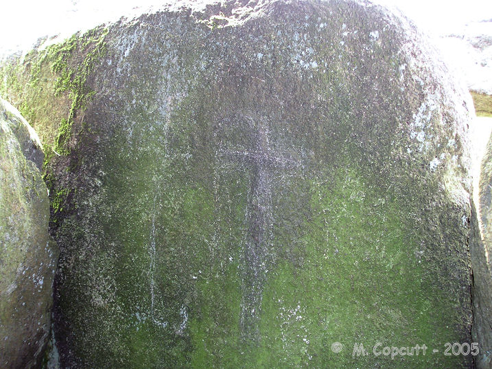
Mougau Bihan submitted by TheCaptain on 1st Dec 2007. The closing stone between the two chambers has a palette and also a wonderful polished axe, contained within its "crosse".
This is one of the least clear engravings, being much more weatherworn than some which have been better protected.
(View photo, vote or add a comment)
Log Text: This is an absolutely splendid allée couverte, which has been dated to 3000BC, found a couple of kilometres to the south of the village of Commana, and signposted from there. It has a little car park and picnic area, as well as a nice and spacious grassy area around it.
The main chamber is 14 metres in length and oriented approximately north to south, with its entrance at the northern end. The southern end has an extra small chamber, the "cella", the two parts being divided by a splendid "chevet" stone. The roof is made of five large capstones, four on the main chamber, and one on the cella. The internal width and height are about 1.5 metres.
But the best thing about this monument is all the ornamental engravings on the internal faces of the stones. About half of the side slabs have engravings on them which are fairly clear to make out. Most of these engravings are what are called "palettes", some stones having several of these of various designs next to each other. One of the stones has two pairs of the double hemispheres on it - these have been largely interpreted as pairs of breasts. The closing stone between the two chambers has a palette and also a wonderful polished axe, contained within its "crosse", but this is one of the least clear engravings, being much more weatherworn than some which have been better protected.
Mougau Bihan translates from the Breton language to "Fairies Cave".
