Contributory members are able to log private notes and comments about each site
Sites theCAptain has logged. View this log as a table or view the most recent logs from everyone
Petit Mont
Trip No.203 Entry No.336 Date Added: 4th May 2020
Site Type: Chambered Tomb
Country: France (Bretagne:Morbihan (56))
Visited: Yes on 10th Jun 2005. My rating: Condition 4 Ambience 3 Access 2

Petit Mont submitted by AlexHunger on 20th Dec 2004. Petit Mont in Arzon, dating to about 4600 BCE at the earliest, is one of the most significant Cairns in Britany, but unfortunately one of the most brutaly vandalized. In 1942, German troops built a bunker and Flak emplacement into the South East Corner of the cairn, which compeltely destroyed one of the chambers and caused the collapse of the second one pictured above, which has since been restored. The megalithic entrance is sought to be an addition from Gallo-Roman times. All pictures have be...
(View photo, vote or add a comment)
Log Text: This enormous cairn, built between 4600 and 2500 BC is on a headland jutting into the sea to the south of the Arzon peninsular. The whole headland is now owned by the local government, and is undergoing major restoration work. The cairn is now well fenced off, and visits were closed for the day when I arrived, so the best I could do was to look at it from a few places through the fence.
There were two large chambers within it originally, with lots of decorations of various types. The whole cairn was much modified by the Germans in 1943 as a part of the Atlantic wall defenses, and concrete bunkers were built within the cairn. These concrete bunkers are being kept, as a valid part of the cairns history and re use.
Luffang Allée Couverte
Trip No.203 Entry No.346 Date Added: 10th May 2020
Site Type: Passage Grave
Country: France (Bretagne:Morbihan (56))
Visited: Yes on 11th Jun 2005. My rating: Condition 2 Ambience 4 Access 4

Luffang Allée Couverte submitted by ermine on 27th Jun 2004. 47.61309N 3.024552W
This passage-grave contained unique artwork on the end stone, now preserved in Carnac museum. Signposted at the site as Allee Couverte
(View photo, vote or add a comment)
Log Text: Easily found in woodland near Luffang, just to the west of Crac'h, this is the remains of a long allée-couverte type structure, but with no coverstones remaining. The allée is not straight, but turns to the left about 45° after 6 metres of the entrance, before another 14 metres of stonelined passageway takes you to the end. Although there are no capstones, many of the sidestones remain in position, and its in nice cool woodland on this hot afternoon.
I understand that there was once a particularly nicely carved stone making up a part of this monument, but I did not spot it on my visit. I wonder whether this site was once within a large mound, rather like the Kernourze tumulus ?
Île Longue tumulus
Trip No.203 Entry No.333 Date Added: 4th May 2020
Site Type: Chambered Tomb
Country: France (Bretagne:Morbihan (56))
Visited: Saw from a distance on 10th Jun 2005
Île Longue tumulus submitted by TheCaptain on 11th Jun 2020. Plan of the tumulus taken from "Il faut qu’une tombe soit ouverte ou fermée" by Charles-Tangay Le Roux
(View photo, vote or add a comment)
Log Text: I took a walk out to the Pointe de Penbert, from where the entrance to the Golfe de Morbihan can clearly be seen, and all the many islands within the gulf. It is a smashing day with a good breeze, and lots and lots of sailing boats are out having fun. There's a cracking tacking duel going on between two large single handed craft as I was writing. It all looks lots and lots of fun.
Just offshore can be seen the islet of Er Lannic, with its double cromlech. Many of the stones stand proud of the island, and indeed the sea, where these half submerged circles are situated, and can clearly be seen from here. Just beyond that is Gavrinis, with its large cairn and entrance overlooking the whole scene. The entrance seems to be looking directly towards me, although in reality it is probably looking a bit more towards the east. The cairn is clearly visible, looking pale against the dark background of a pinewood. A boat trip of people has just landed on the island for the guided visit to the cairn, with its magnificent carvings.
A bit further away to the west is Isle Longue, with its large tumulus at the south end of the island visible, and beyond that is Locmariaquer, with all its sites.
Bilgroix allée couverte
Trip No.203 Entry No.334 Date Added: 4th May 2020
Site Type: Passage Grave
Country: France (Bretagne:Morbihan (56))
Visited: Yes on 10th Jun 2005. My rating: Condition 5 Ambience 5 Access 5
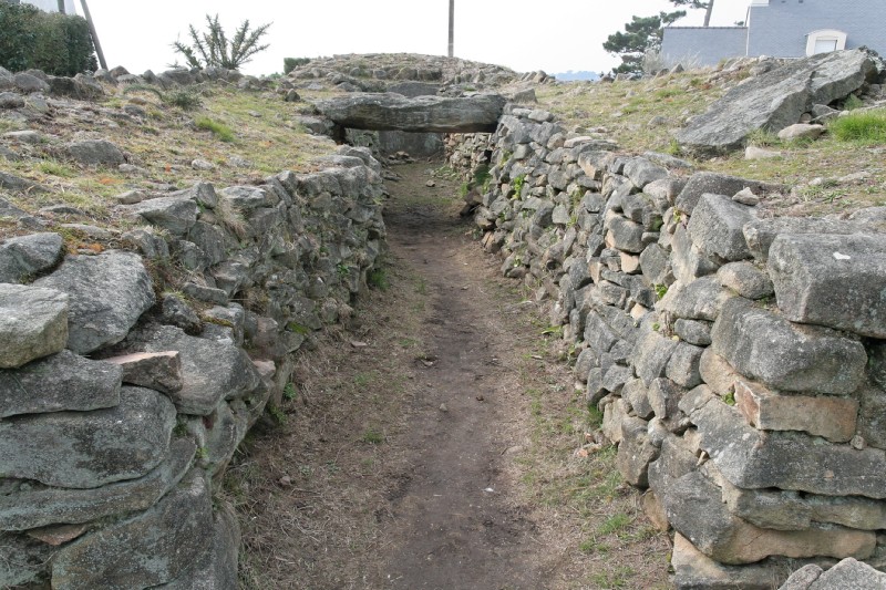
Bilgroix allée couverte submitted by dt44 on 21st Mar 2010.
(View photo, vote or add a comment)
Log Text: This is an unusual monument, right near to the end of the northern headland at the entrance to the Golfe de Morbihan, said to date from around 2700BC and unique in western France. It is an allée-couverte with a passage about 10 metres long, but other than a large slab at the back (western) end, it was made completely out of small stone blocks and drystone walling, with capstones placed on top of this. The long mound surrounding the passageway has two drystone walling sections.
The whole monument was later incorporated into defensive ditches and structures on the headland, which no doubt helped with its conservation. It is nowadays set in a delightful garden type area amongst all the houses, and when I was here in early June, it was all awash with brightly coloured flowers of all sorts. Californian poppies, lavatera, pinks, sweet-peas, carnations, marrigolds, daisies, and many others. Absolutely lovely.
Tumulus du Rocher
Trip No.203 Entry No.344 Date Added: 10th May 2020
Site Type: Chambered Tomb
Country: France (Bretagne:Morbihan (56))
Visited: Yes on 11th Jun 2005. My rating: Condition 5 Ambience 4 Access 4

Tumulus du Rocher submitted by greywether on 30th Jun 2005. Angled pasage grave with some decorated stones. The entrance.
(View photo, vote or add a comment)
Log Text: Signposted, and with a parking area, this is a great find. There is a little walk along a wooded headland above the Bono river, and not knowing what to expect here, I was more than pleasantly surprised. It is signposted "Tumulus et Tombettes", and as well as a big tumulus, there are the remains of half a dozen or more smaller tumuli approximately in a line along the ridgetop.
The large tumulus is 30 metres in diameter and about 5 metres in height, with a single entranceway in the southeastern side which is open to the public. Bring a torch. The entrance leads into a curving passage, which is approximately L shaped, and about 20 metres in length, two sections of about 10 metres each. The passageway is made up out of a mix of upright slabs and drystone walling, covered with capstones. It is not quite high enough to stand up in until the end of the passage, where it opens up to 2 metres wide and high. Several of the upright stones have carvings on them, axes, crooks, serpentines etc, but these were difficult to see in the dark with the poor light I had with me. FANTASTIC !
The tombettes vary in size from about 10 metres in diameter downwards, and most are nowadays fairly flat. Most consist of the outline of some sort of burial chamber, with a surrounding circle of stones. Various chamber types are to be seen, from simple rectangles to full length stone lined passages. I don't know why this place is not more well known, I didn't really know of it before I visited, and its one of my favourite sites so far. Think I'll go for another look inside the big mound.
Men-Milene
Trip No.203 Entry No.363 Date Added: 11th May 2020
Site Type: Standing Stone (Menhir)
Country: France (Bretagne:Morbihan (56))
Visited: Couldn't find on 12th Jun 2005

Men-Milene submitted by regina on 30th Oct 2014. Site in Bretagne:Morbihan (56) France
(View photo, vote or add a comment)
Log Text: To the southwest of the Chat Noir roundabout is the hamlet of Kerangoff, where there can be found a dolmen and a menhir. The menhir proved impossible for me to find, hidden somewhere in the forest behind the houses amongst the ferns and gorse, despite a longish walk around all the area.
Dolmen de Mane Rohr
Trip No.203 Entry No.366 Date Added: 11th May 2020
Site Type: Burial Chamber or Dolmen
Country: France (Bretagne:Morbihan (56))
Visited: Couldn't find on 12th Jun 2005

Dolmen de Mane Rohr submitted by Martin_L on 31st Jan 2009. Dolmen de Mane Rohr at dusk in May 2001. It is an absolutely terrific site, but somewhat overgrown. In 2001 it was possible to cross a sports ground and then follow a narrow track through a little "jungle". It is not signposted, but if you are in this area you should buy the 1:25000 map anyway :-)
(View photo, vote or add a comment)
Log Text: Despite being clearly marked on the map, besides the sports ground and with a footpath to it, I could find no way through the houses to the hilltop position in the real world.
Dolmen de La Madeleine (Carnac)
Trip No.203 Entry No.370 Date Added: 11th May 2020
Site Type: Burial Chamber or Dolmen
Country: France (Bretagne:Morbihan (56))
Visited: Yes on 12th Jun 2005. My rating: Condition 3 Ambience 3 Access 3

Dolmen de La Madeleine (Carnac) submitted by minteddy on 10th Sep 2008. Site in Bretagne, Morbihan D56: Grid ref 03 02’ 54’’ West 47 37’ 16’’ As can be seen, this dolmen is in a ruinous state. The capstone has slipped off its supports on one side.
(View photo, vote or add a comment)
Log Text: Blimey, this dolmen is not hidden in dense woodland ! It is to be found in an open field at the top of a little raise, but the field was closed off with an electric fence, so I didn’t go in to see the dolmen at close quarters.
Menhir de Crucuny 1
Trip No.203 Entry No.372 Date Added: 11th May 2020
Site Type: Standing Stone (Menhir)
Country: France (Bretagne:Morbihan (56))
Visited: Couldn't find on 12th Jun 2005

Menhir de Crucuny 1 submitted by stollentroll on 14th Dec 2005. Menhir on top of the tumulus Crucuny.
(View photo, vote or add a comment)
Log Text: On top of the tumulus, to the north of the hamlet, is a menhir, 2.8 metres tall, with axes carved on it. But it is all very overgrown and covered in gorse, and I could not get to see anything at close quarters.
Mané-Brizil Dolmen
Trip No.203 Entry No.374 Date Added: 11th May 2020
Site Type: Burial Chamber or Dolmen
Country: France (Bretagne:Morbihan (56))
Visited: Saw from a distance on 12th Jun 2005

Mané-Brizil dolmen submitted by binardino on 14th Jun 2006. Mané-Brizil dolmen
(View photo, vote or add a comment)
Log Text: This dolmen is now within private property, but a few stones of what is possibly the dolmen with couloir can be seen inside the entrance of a large chateau like place, up the driveway entrance.
Kerlescan cromlech
Trip No.203 Entry No.379 Date Added: 11th May 2020
Site Type: Stone Circle
Country: France (Bretagne:Morbihan (56))
Visited: Yes on 12th Jun 2005. My rating: Condition 4 Ambience 4 Access 5
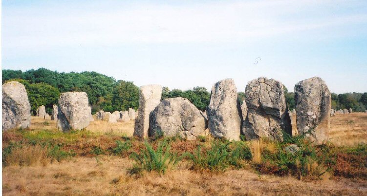
Kerlescan cromlech submitted by LizH on 31st Oct 2007. The eastern stones of the western Kerlescan cromlech. The stones touch each other and face across (N-S) rather than being aligned E-W as the rows are.
(View photo, vote or add a comment)
Log Text: None
Mane Lud Dolmen
Trip No.203 Entry No.352 Date Added: 10th May 2020
Site Type: Chambered Cairn
Country: France (Bretagne:Morbihan (56))
Visited: Yes on 11th Jun 2005. My rating: Condition 4 Ambience 4 Access 4
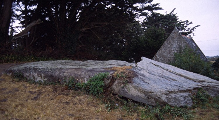
Mane Lud dolmen submitted by greywether on 30th Jun 2005. The massive broken granite capstone over the chamber (8.5 x 4.9m).
(View photo, vote or add a comment)
Log Text: This is just a few hundred metres away from the famed sites at the Grande Menhir Brise, but it is not visited by many people, yet I think it is a better site than the Table des Marchands.
Still within its large long cairn of stones, it doesn’t look much from the outside, just a large broken capstone at the western end of the long mound. But a closer inspection shows there to be a passage down past a little chapel which has been built onto the end of it, which allows access into a large chamber.
The chamber is about 4 metres by 3 metres, and high enough to stand up in, and has many decorated stones, with a carved floor stone with an axe or plough in raised relief. The passageway to the chamber is about 10 metres in length, with about 5 metres at the chamber end being still covered, while the first 5 metres are open and much altered by the building of the chapel.
Mane-Rethuel Dolmen
Trip No.203 Entry No.353 Date Added: 10th May 2020
Site Type: Burial Chamber or Dolmen
Country: France (Bretagne:Morbihan (56))
Visited: Yes on 11th Jun 2005. My rating: Condition 4 Ambience 4 Access 4
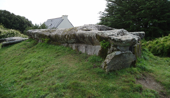
Mane-Rethuel dolmen submitted by AlexHunger on 21st Sep 2004. Dolmen de Mane-Rithual in central Locmariaquer viewed from North. Entrance is at oposite end.
(View photo, vote or add a comment)
Log Text: I thought I had seen some pretty impressive megalithic constructions before, but the Locmariaquer ones are making me think again. This is a massively long passage grave, built in at least two different ages. The first stage is a 3 metre by 2 metre oval chamber at the end of a 10 metre passage opening at a bearing of 108°. At least one large ex menhir is used in the capstones of this passage.
Then at a later stage, a second 4 m by 3 m oval chamber was added at the back end, using part of a massive broken menhir, 11 metres in length, from near the Grande Menhir Brise as its capstone. This stone has a 6 metre long carving on its underside which gives evidence of its previous usage. Inside the first chamber are carvingss of axes, ploughs etc, and a stele, probably also moved here from elsewhere. Whoever built this monument must have employed a right bunch of cowboy builders, although their construction has stood the ravages of time well.
Mané-er-Hroëck tumulus
Trip No.203 Entry No.354 Date Added: 10th May 2020
Site Type: Chambered Tomb
Country: France (Bretagne:Morbihan (56))
Visited: Yes on 11th Jun 2005. My rating: Condition 4 Ambience 4 Access 4

Mané-er-Hroëck tumulus submitted by greywether on 30th Jun 2005. The modern entrance to this underground chamber.
(View photo, vote or add a comment)
Log Text: Blimey, whatever next ? This is a large mound of stones, just to the south of the village of Locmariaquer. A path leads up between the houses to the top of the tumulus, of which the shape and size are indeterminate due to the houses all around it. Once on top of the tumulus, a set of relatively modern steps cut downwards into the heart of the mound through the stones. Down it goes, round a corner, and then, 10 metres in and 5 metres down, there is an entrance into a chamber.
It is a simple chamber, about 5 metres by 3 metres, but not quite high enough to stand up straight in. The walls are largely drystone, with a couple of large capstones forming the roof. I could not make out if there were any carvings, but it was dark and my lamp was fairly feeble. This is another fantastic find, and again passed by and missed by the masses. Take a good torch.
Pierres Plates (Locmariaquer)
Trip No.203 Entry No.356 Date Added: 10th May 2020
Site Type: Burial Chamber or Dolmen
Country: France (Bretagne:Morbihan (56))
Visited: Yes on 11th Jun 2005. My rating: Condition 4 Ambience 5 Access 4

Pierres Plates (Locmariaquer) submitted by ermine on 27th Jun 2004. Les Pierres Plates
(View photo, vote or add a comment)
Log Text: This famous angled passage grave with its many sculpted stones is right at the end of the Locmariaquer peninsular overlooking the sea, and still mostly within a small covering mound. The chamber turns about 45 degrees to the left after about 6 metres, with a side chamber bisecting the angle. From this corner, there is about another 10 metres of passage to the final chamber, seperated from the widening passage by a nicely carved stone. The carvings on the passageway side supports get more exotic the further you get into the monument.
Although the entire passageway is covered, I think most of the stones used are modern replacements. Take a good torch with you to see the details of all the carved stones. Unfortunately, my camera started misbehaving here, and the flash would not work properly, and so I couldn't get any decent pictures from within the tomb. However, this place is thoroughly documented in many other places.
Pointe Er Hourél Dolmen
Trip No.203 Entry No.358 Date Added: 10th May 2020
Site Type: Burial Chamber or Dolmen
Country: France (Bretagne:Morbihan (56))
Visited: Yes on 11th Jun 2005. My rating: Condition 2 Ambience 5 Access 3
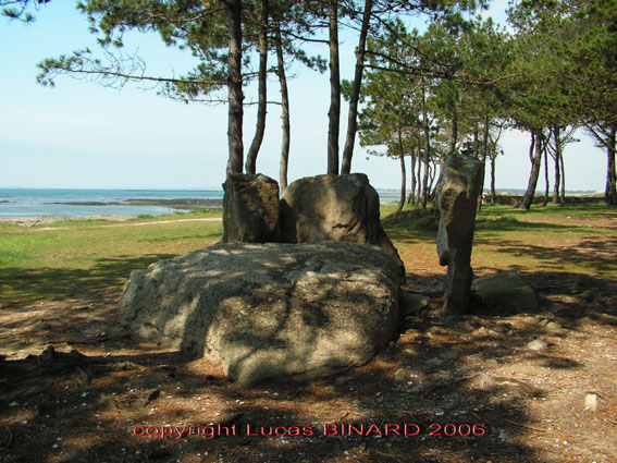
Pointe Er Hourél Dolmen submitted by binardino on 19th Jun 2006. Pointe Er Hourel Dolmen
(View photo, vote or add a comment)
Log Text: This dolmen is in just about the best position of any I have been to, out near the end of Er Hourel point in a little pinewood. Access is either by a fair walk from the nearest car park for Plage St Pierre, or the way I did it was by an excellent off road bike route from Locmariaquer, which took me along country lanes, across tidal weirs, up a creek, round some gardens and a few places where I had to carry the bike before reaching the last kilometre along the sands. This route is not to be attempted at high tide !
When I was here, the sun was setting in the west over Carnac and the Arzon peninsular was all lit up in the golden sky to the east, Quiberon and the islands can be seen across the sea speckled with sailing boats, while the wind rushes through the pines. Absolutely smashing. Pity that I have to make my way back soon.
The dolmen isn't much, a few support stones standing round a fallen capstone of what would have been a 2 metre wide chamber. How long it would have been is anybodies guess, it could be just 2 metres, or it could be like the nearby Pierres Plates and be up to 20 metres long. The floor of the chamber is paved.
Kerlescan nord allée couverte
Trip No.203 Entry No.381 Date Added: 11th May 2020
Site Type: Passage Grave
Country: France (Bretagne:Morbihan (56))
Visited: Yes on 12th Jun 2005. My rating: Condition 3 Ambience 4 Access 4

Kerlescan nord allée couverte submitted by Martin_L on 22nd Jan 2009. Inside the chamber.
(May 2001)
(View photo, vote or add a comment)
Log Text: The remains of this monument can be found at the eastern end of the Kerlescan alignements, around the back to the north, and in a wood. It is about 60 metres long by 8 metres wide tumulus, completely surrounded by a stone peristalith. Inside this mound is a 16 metre long lateral entrance allee couverte type structure, but unfortunately with only one remaining capstone at the western end. Its entry is from the southern side near the east end. The mound is rectangular in shape at the western end, and curved at the east, and is still 2 or 3 metres high.
Ménec cromlech
Trip No.203 Entry No.382 Date Added: 11th May 2020
Site Type: Stone Circle
Country: France (Bretagne:Morbihan (56))
Visited: Yes on 12th Jun 2005. My rating: Condition 4 Ambience 4 Access 5

Ménec cromlech submitted by AlexHunger on 20th Dec 2004. The Cromlec de Menec marks the westernmost extent of the Carnac Allignments. It basically starts on the road that separates it from the allignments, goes through a private garden, through the end of the village and ends in a creperie.
(View photo, vote or add a comment)
Log Text: Curving around the Creperie at the western end of the Menec alignements, this almost contiguous semicircle of stones really is splendid, and most people who visit the nearby stones do not know that it is there, or think that it’s a wall. All sorts of other bits of the cromlech can be found in between the buildings of the Menec hamlet. This place really is magic without the people.
Cruz Menquen dolmen
Trip No.203 Entry No.384 Date Added: 11th May 2020
Site Type: Burial Chamber or Dolmen
Country: France (Bretagne:Morbihan (56))
Visited: Yes on 12th Jun 2005. My rating: Condition 3 Ambience 3 Access 5

Cruz Menquen dolmen submitted by greywether on 28th Jun 2005.
(View photo, vote or add a comment)
Log Text: In amongst the homes near to the sports facilities to the north of the town is Carnac's own dolmen. It is a small affair, with a 2.5 m by 2 metre capstone mounted on three support stones. On top of the capstone has been mounted a large, 2.5 metre tall cross.
Geant du Manio
Trip No.203 Entry No.385 Date Added: 14th May 2020
Site Type: Standing Stone (Menhir)
Country: France (Bretagne:Morbihan (56))
Visited: Yes on 13th Jun 2005. My rating: Condition 4 Ambience 4 Access 4
Geant du Manio submitted by rw1 on 3rd Mar 2008. 09/2007
(View photo, vote or add a comment)
Log Text: This is a 5 metre high menhir, fairly easily found and obviously very popular because of all the erosion around it. It is only 50 metres from the quadrilateral. It’s a very nice stone in the woodland, but I guess it can become a bit of a nightmare when crowded.
