Contributory members are able to log private notes and comments about each site
Sites theCAptain has logged. View this log as a table or view the most recent logs from everyone
Adlestrop Hill
Date Added: 18th Sep 2010
Site Type: Long Barrow
Country: England (Gloucestershire)
Visited: Yes on 3rd Apr 2006

Adlestrop Hill submitted by thecaptain on 3rd Apr 2006. Adlestrop Hill long barrow.
Just about found and identified after a long search by about a dozen hardened stonehunters, and a couple of full time archaeologists.
(View photo, vote or add a comment)
Log Text: None
Ibsley Common barrows
Date Added: 18th Sep 2010
Site Type: Barrow Cemetery
Country: England (Hampshire)
Visited: Yes on 6th May 2006

Ibsley Common barrows submitted by thecaptain on 6th May 2006. On the western edge of the New Forest plateau above the river Avon is this fine disc barrow with splendid views in all directions.
This is the view towards the northeast.
(View photo, vote or add a comment)
Log Text: None
Grim’s Grave
Date Added: 18th Sep 2010
Site Type: Cairn
Country: England (Devon)
Visited: Yes on 27th Jul 2006

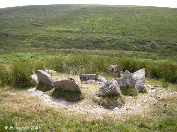
Grim’s Grave submitted by thecaptain on 27th Jul 2006. What a lovely find this is, miles from anywhere across the middle of Southern Dartmoor, and well worth a visit.
This cairn is surrounded by 9 large upright slabs making a full circle, some of which are over a metre in height. In the centre is a large rectangular kist, about 1.5 by 1 metre, and almost 1 metre deep
(View photo, vote or add a comment)
Log Text: None
The Heath Stone
Date Added: 18th Sep 2010
Site Type: Standing Stone (Menhir)
Country: England (Devon)
Visited: Yes on 29th Jul 2006

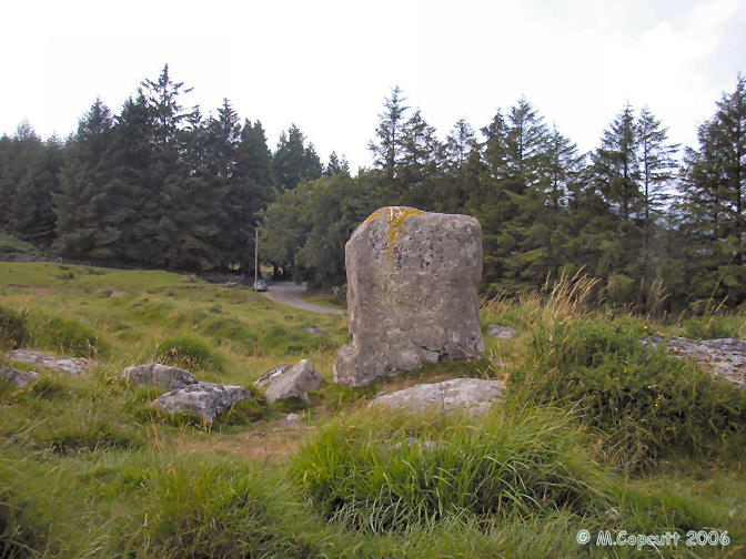
The Heath Stone submitted by thecaptain on 29th Jul 2006. The Heath Stone can be found not far from the road on the way to Fernworthy Reservoir, on the open moor just before you get to the forest.
(View photo, vote or add a comment)
Log Text: None
Dry Lake North Settlement
Date Added: 18th Sep 2010
Site Type: Ancient Village or Settlement
Country: England (Devon)
Visited: Yes on 29th Jul 2006

Dry Lake North Settlement submitted by thecaptain on 29th Jul 2006. Fairly well preserved ancient settlement on the eastern flanks of the Erme valley, consisting of several large walled enclosures, each containing several huts.
(View photo, vote or add a comment)
Log Text: None
Blatchford Brook Foot Settlement
Date Added: 18th Sep 2010
Site Type: Ancient Village or Settlement
Country: England (Devon)
Visited: Yes on 29th Jul 2006

Blatchford Brook Foot Settlement submitted by thecaptain on 29th Jul 2006. Blatchford Brook Foot Settlement is a well preserved bronze age settlement on the eastern flanks of the Erme valley.
(View photo, vote or add a comment)
Log Text: None
Crock of Gold
Date Added: 18th Sep 2010
Site Type: Cairn
Country: England (Devon)
Visited: Yes on 1st Aug 2006
Crock of Gold submitted by thecaptain on 1st Aug 2006. The Crock of Gold is a fine cairn and cist which can be found just to the south of the track which runs east from Princetown as part of the Dartmoor way, and is named no doubt after a lucky find here by somebody in the past.
This is the view looking northeast.
(View photo, vote or add a comment)
Log Text: None
Bennet's Cross
Date Added: 18th Sep 2010
Site Type: Ancient Cross
Country: England (Devon)
Visited: Yes on 2nd Aug 2006
Bennet's Cross submitted by thecaptain on 2nd Aug 2006. This is a lovely cross, believed to have been carved from a prehistoric menhir.
It stands about 1.7 metres tall, and is just beside the B3212 road near its high point as it crosses the moor between Moretonhampstead and Postbridge.
(View photo, vote or add a comment)
Log Text: None
Royal Hill Cairns
Date Added: 18th Sep 2010
Site Type: Cairn
Country: England (Devon)
Visited: Yes on 2nd Aug 2006
Royal Hill Cairns (SX621723) submitted by thecaptain on 2nd Aug 2006. Royal Hill Cairn 4
In the centre is a large cist, about 1 metre square, with its capstone displaced to the edge of the cairn.
(View photo, vote or add a comment)
Log Text: None
Ranny Brookhead Cist
Date Added: 18th Sep 2010
Site Type: Cist
Country: England (Devon)
Visited: Yes on 3rd Aug 2006
Ranny Brookhead Cist submitted by thecaptain on 3rd Aug 2006. Ranny Brookhead cist is in the middle of a featureless bit of moor near the bottom of the dip between Stall Moor and Stalldown Barrow, in amongst the damp ground surrounding the Ranny Brook.
(View photo, vote or add a comment)
Log Text: None
Hurston Ridge
Date Added: 18th Sep 2010
Site Type: Multiple Stone Rows / Avenue
Country: England (Devon)
Visited: Yes on 11th Aug 2006
Hurston Ridge submitted by thecaptain on 11th Aug 2006. The top half of the lovely Hurston Ridge double stone row.
Viewed here looking towards the southeast.
(View photo, vote or add a comment)
Log Text: None
Hook Lake Settlement
Date Added: 18th Sep 2010
Site Type: Ancient Village or Settlement
Country: England (Devon)
Visited: Yes on 13th Aug 2006
Hook Lake Settlement submitted by thecaptain on 13th Aug 2006. Well preserved ancient settlement on the eastern flanks of the Erme valley, consisting of two large walled enclosures, the one to the north a circular shape, with a sort of triangular one to the south. Each enclosure contains several huts.
(View photo, vote or add a comment)
Log Text: None
Stall Moor circle
Date Added: 18th Sep 2010
Site Type: Stone Circle
Country: England (Devon)
Visited: Yes on 14th Aug 2006
Stall Moor circle submitted by thecaptain on 14th Aug 2006. Kiss-in-the-Ring stone circle, seen here looking south, with the southern end of the longest known prehistoric stone row (more than 3 km in length) leading to it in the foreground.
In the distance of the picture is Stalldown Barrow hill, with the wonderful Stalldon Row marching over its summit, which can be seen clearly in real life.
The river Erme valley is to the left of the picture.
(View photo, vote or add a comment)
Log Text: None
Upper Erme Row
Date Added: 18th Sep 2010
Site Type: Stone Row / Alignment
Country: England (Devon)
Visited: Yes on 23rd Aug 2006
Upper Erme Row submitted by thecaptain on 23rd Aug 2006. At the southern end, the row starts at the 16 metre diameter Kiss-in-the-Ring stone circle.
From here the row runs northwards, with the stones generally about half a metre tall above the modern turf, and spaced at intervals of about 1.5 to 2 metres. The grass around these stones is in July very long, and many of the stones are very difficult to see, but the path of the row is clearly seen by the darker shade of the grass surrounding them, and also for the path which runs alongside.
(View photo, vote or add a comment)
Log Text: None
Upper Erme Cairns
Date Added: 18th Sep 2010
Site Type: Cairn
Country: England (Devon)
Visited: Yes on 28th Aug 2006
Upper Erme Cairns submitted by thecaptain on 28th Aug 2006. Upper Erme Cairn 2 is a large cairn just upslope from the stone row about half a kilometre from the southern end. It is about 15 metres in diameter, and still well over a metre high.
(View photo, vote or add a comment)
Log Text: None
Childe’s Tomb
Date Added: 18th Sep 2010
Site Type: Cairn
Country: England (Devon)
Visited: Yes on 28th Aug 2006
Childe’s Tomb submitted by thecaptain on 28th Aug 2006. Childe’s Tomb, viewed looking north east.
(View photo, vote or add a comment)
Log Text: None
Stalldon Row
Date Added: 18th Sep 2010
Site Type: Stone Row / Alignment
Country: England (Devon)
Visited: Yes on 1st Sep 2006
Stalldon Row submitted by thecaptain on 1st Sep 2006. Myself stood beside the northern stones of Stalldon Row in order to give some scale.
These stones on the top of the hill can be seen from miles away, and look like some lonely hikers at first, until you realise thay are not moving.
(View photo, vote or add a comment)
Log Text: None
Pierre-aux-Fées
Date Added: 18th Sep 2010
Site Type: Rock Art
Country: France (Auvergne:Puy-de-Dôme (63))
Visited: Yes on 5th Sep 2006
Pierre-aux-Fées (St-Micaud) submitted by thecaptain on 5th Sep 2006. The Pierre-aux-Fées is about 7 metres tall, and has perhaps got some carvings on it.
(View photo, vote or add a comment)
Log Text: None
Drove Cottage Henge
Date Added: 18th Sep 2010
Site Type: Henge
Country: England (Somerset)
Visited: Yes on 11th Sep 2006
Drove Cottage Henge submitted by thecaptain on 11th Sep 2006. A 55 metre diameter henge which can be seen in a field to the south of Hillgrove Road to the north of Wells, and to the east of Priddy.
The earthworks can clearly be seen in the field, but without proper access to the field, it was difficult to fully determine what is there.
(View photo, vote or add a comment)
Log Text: None
Pen Hill Longbarrow
Date Added: 18th Sep 2010
Site Type: Long Barrow
Country: England (Somerset)
Visited: Yes on 12th Sep 2006
Pen Hill Longbarrow submitted by thecaptain on 12th Sep 2006. This is a 45 metre long by 15 metre wide longbarrow which is to be found in a little fenced enclosure, just to the south of the summit of Pen Hill at the southern edge of the Mendip Hills just north of Wells.
The view to the southwest from here is fantastic, with the Somerset Levels spread out below.
(View photo, vote or add a comment)
Log Text: None
