Contributory members are able to log private notes and comments about each site
Sites theCAptain has logged. View this log as a table or view the most recent logs from everyone
Harbourne Head B
Date Added: 4th Mar 2023
Site Type: Ring Cairn
Country: England (Devon)
Visited: Yes on 24th Feb 2023. My rating: Condition 3 Ambience 4 Access 3

Harbourne Head B submitted by Bladup on 18th Jan 2016. The South East Cairn.
(View photo, vote or add a comment)
Log Text: From the menhir I walk up to the top of the hill to look at the two ring cairns. Both quite large diameter, seemingly a ring of stone around a flat inside with a pile in the middle. The southern of the two is more distinct, and the central mound and ring are more obviously comprised of stones. I didn't see anything resembling a circle of upright stones!
Harbourne Head A
Date Added: 4th Mar 2023
Site Type: Ring Cairn
Country: England (Devon)
Visited: Yes on 24th Feb 2023. My rating: Condition 3 Ambience 4 Access 3
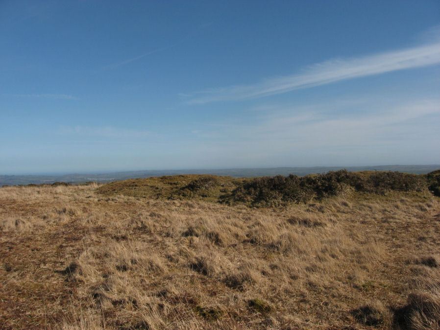
Harbourne Head A submitted by davep on 24th Oct 2019. The Harbourne Head A Stone Ring Cairn Circle from the Prehistoric Dartmoor Walks (PDW) website, site 555.
(View photo, vote or add a comment)
Log Text: From the menhir I walk up to the top of the hill to look at the two ring cairns. Both quite large diameter, seemingly a ring of stone around a flat inside with a pile in the middle. The northern of the two is less distinct and more grassy. I didn't see anything resembling a circle of upright stones!
Hangman's Stone (Northleach)
Date Added: 18th Sep 2010
Site Type: Standing Stone (Menhir)
Country: England (Gloucestershire)
Visited: Yes on 14th Jan 2007
Hangman's Stone (Northleach) submitted by thecaptain on 14th Jan 2007. The situation of the Hangman's Stone.
Easily found to the west of Northleach, near a radio mast.
(View photo, vote or add a comment)
Log Text: None
Hanging Stone (Lee Moor)
Date Added: 30th Apr 2022
Site Type: Standing Stone (Menhir)
Country: England (Devon)
Visited: Would like to visit
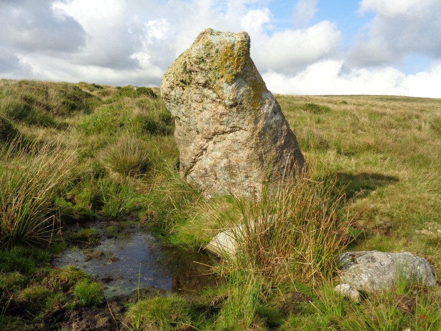
Hanging Stone (Lee Moor) submitted by davep on 23rd Oct 2019. The Hanging Stone Standing Stone from the Prehistoric Dartmoor Walks (PDW) website. Photograph taken 25th August 2017
(View photo, vote or add a comment)
Hamel Down Platform Cairn (North)
Date Added: 31st Dec 2022
Site Type: Cairn
Country: England (Devon)
Visited: Yes on 6th Dec 2022. My rating: Condition 2 Ambience 4 Access 3
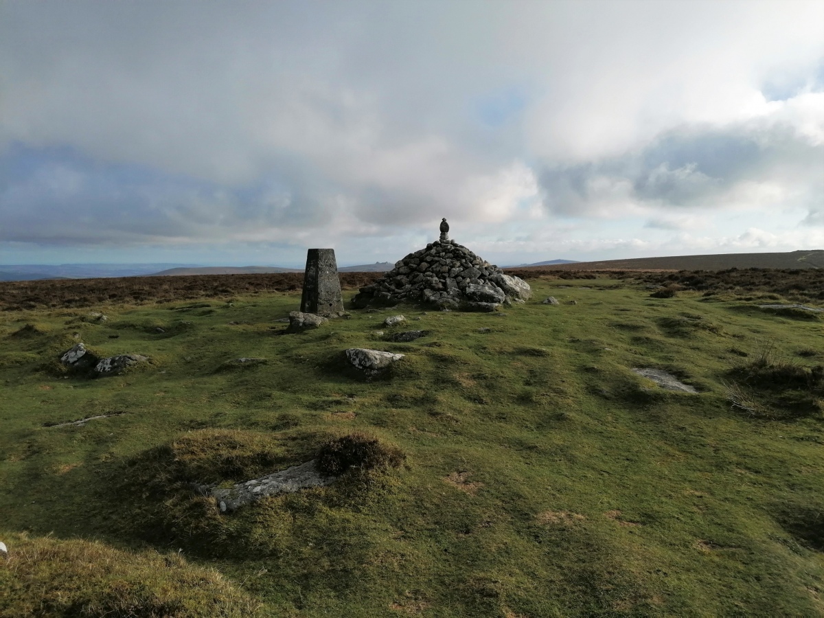
Hamel Down Platform Cairn (North) submitted by TheCaptain on 31st Dec 2022. Atop Hamel Down tor there is a large cairn and trig point. It looks to me as though the current pile of stones is a relatively modern construction, but there seems to be a large circular platform which is presumably the base of the original cairn here, with some large stones spaced around it.
Viewed here looking southeast, with Haytor and Rippon Tor framing the cairn top
(View photo, vote or add a comment)
Log Text: Climb up to the top of Hamel Down for a walk along the ridge, with splendid views down onto Grimspound from the slopes. Once at the top there is a large cairn and trig point. It looks to me as though the current pile of stones is a relatively modern construction, but there seems to be a large circular platform which is presumably the base of the original cairn here, with some large stones spaced around it. Beautiful views all around, I spend some time trying to figure out all of the various tors and features which can be seen.
Hamel Down Cross
Date Added: 27th Jan 2023
Site Type: Ancient Cross
Country: England (Devon)
Visited: Yes on 6th Dec 2022. My rating: Condition 3 Ambience 4 Access 3

Hamel Down Cross submitted by TheCaptain on 27th Jan 2023. Hamel Down Cross viewed looking east
(View photo, vote or add a comment)
Log Text: Walking back northwards along the ridge and from the top of Broad Barrow, Hamel Down Cross can be seen shining in the sun away from the modern track to the west, so I go for a look. It’s a lovely weathered old stone cross which has lost its head and one of its arms. It has some sort of carving on it's east face, probably a Duke of Somerset boundary marking, but the cross clearly predates that.
Hamel Down Beacon cairn
Date Added: 14th Jan 2023
Site Type: Cairn
Country: England (Devon)
Visited: Yes on 6th Dec 2022. My rating: Condition 3 Ambience 4 Access 3

Hamel Down Beacon cairn submitted by TheCaptain on 14th Jan 2023. On the southern top of Hameldown at 517m, at a corner of the field wall, is a prominent large cairn. The field wall makes no attempt to avoid the cairn, running right over it, but not across the centre. The cairn has been cut away from the western side within the walled field.
Here seen from the south.
(View photo, vote or add a comment)
Log Text: On to the southern top of Hameldown at 517m, at a corner of the field wall, is another prominent large cairn, again with a Duke Stone on its top. The field wall makes no attempt to avoid the cairn, running right over it, but not across the centre. From here the views to the south open up with almost the whole of the southern moor and southeast Devon to be seen.
Hambury Tout Barrows
Date Added: 29th Oct 2019
Site Type: Barrow Cemetery
Country: England (Dorset)
Visited: Yes on 15th Oct 2018
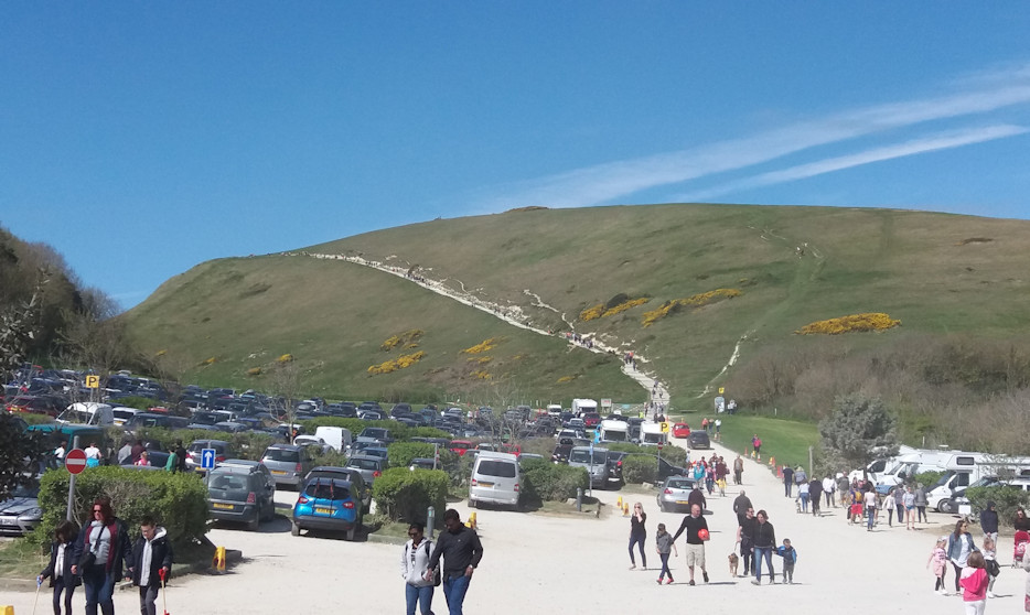
Hambury Tout Barrows submitted by TheCaptain on 15th Oct 2018. View of Hambury Tout Hill, from the car park at Lulworth Cove, Easter 2017.
There are a couple of barrows on top of Hambury Tout, near the busy coast path on top of the steep hill between Lulworth Cove and Durdle Dor. Absolutely beautiful here, but can get very crowded, and was on a sunny Good Friday.
(View photo, vote or add a comment)
Log Text: None
Halliggye
Date Added: 28th Jul 2022
Site Type: Souterrain (Fogou, Earth House)
Country: England (Cornwall)
Visited: Yes on 16th Jun 2022. My rating: Condition 5 Ambience 5 Access 3
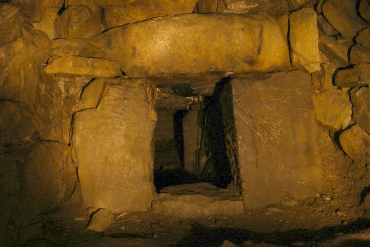
Halliggye submitted by JimChampion on 29th Sep 2006. Entrance to the creep at the northern end of the main passage. The original entrance (now bricked up and buried) is at the far end of this creep.
(View photo, vote or add a comment)
Log Text: A day down to The Lizard for a couple of fogous and the Verdant Brewery. Start with Halliggye Fogou, but found it hard to find in the Trelowarren Estate. After driving all around the estate, I found a place to park near the house, but could still find no obvious signs to the fogou despite it being in the care of EH. After a lot of walking and asking people, I eventually found it. The way back to the car was easier, and at a sort of back entrance to the carpark there was indeed a sign with a map showing the way to the fogou. Once you find the fogou, what a fabulous thing it is. It is set within a little tended area, and there is a plan of what to find underground. This does help to orientate yourself once in, but it is pitch black and a good torch is needed. My torch was not great, so I found myself stumbling about a bit! The way down into the fogou was narrow and damp, despite there being no rain for several days, then past some iron gates used to close the fogou to the public at certain times to protect the bats, then into the dark. Two long passages and two small creep passages, all in total darkness. In the further passage I had a couple of bats flying around, but disappointingly never got one in a picture. Magic.
Halicarnassus Mausoleum
Date Added: 10th Nov 2010
Site Type: Chambered Tomb
Country: Turkey
Visited: Yes on 18th Sep 2002. My rating: Condition 2 Ambience 4 Access 4

Halicarnassus Mausoleum submitted by thecaptain on 28th Mar 2007. The modern day remains of Halicarnassus Mausoleum in Bodrum Turkey.
Most of the stones originally used in the building of this "one of the seven wonders" are now built into the walls of Bodrum castle.
(View photo, vote or add a comment)
Log Text: The wind has got up overnight and is apparently too strong out at sea for us to go out for the day. This is only the third day that’s been cancelled all season. Still, it’s no problem, as we can go to Bodrum for the day and do the tourist thing. I never knew before that Bodrum was the ancient city of Halicarnassos, and home to one of the seven ancient wonders. What an amazing history the place has. The Dolmus takes about 20 minutes and costs about 30p each. Brilliant.
First off, we head for the remains of the Halicarnassos Mausoleum, the ancient wonder of the world. It was built by Queen Artemesia for her brother and husband, King Mausolus in 355BC.
What an amazing place it must have been, about 7 storeys high. But when the Knights of St John got there in 1494, they decided it was nothing more than a fantastic pile of stone with which to build their castle. So now there’s almost nothing left.
There is remains of an amazing drainage system and robber tunnels where ancient people tried to get in for treasure, and a few bits of massive column, but not much else.
Halicarnassus
Date Added: 29th Oct 2019
Site Type: Ancient Village or Settlement
Country: Turkey
Visited: Yes on 30th Nov 2010
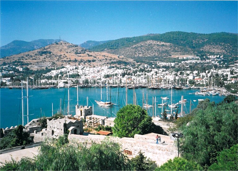
Halicarnassus submitted by theCaptain on 30th Nov 2010. View over Bodrum harbour to the site of ancient Halicarnassus from the Castle.
The remains of the ancient theatre can be seen carved into the hillside near the upper left of the picture, above the yacht masts.
(View photo, vote or add a comment)
Log Text: None
Halangy Down
Date Added: 11th Oct 2020
Site Type: Ancient Village or Settlement
Country: England (Isles of Scilly)
Visited: Yes on 8th Sep 1986
Halangy Down Settlement submitted by Thorgrim on 1st Jul 2003. Iron Age courtyard house settlement similar to Chysauster. Situated on St Marys at SV 90981237, it overlooks the sea and is below the much older Bant's Carn entrance grave.
(View photo, vote or add a comment)
Log Text: During a 2 week sailing trip with friends, I left the rest of the crew to sail L'Aurian from St Mary's all the way round the Western Rocks and in to New Grimsby harbour, Tresco for the night. I spent the day walking round the entire coast of St Mary's visiting many ancient sites, before catching a ferry over to Bryher in the evening and getting picked up by the crew.
Hague-Dick
Trip No.202 Entry No.27 Date Added: 26th Mar 2020
Site Type: Misc. Earthwork
Country: France (Normandie:Manche (50))
Visited: Yes on 26th Apr 2005. My rating: Condition 3 Ambience 2 Access 5

Hague-Dick submitted by TheCaptain on 9th May 2005. Several square miles at the northwestern tip of the Cherbourg peninsula, was once defended from the rest of the world by a 2 mile long ditch and bank, which connected between two deep valleys to defend the whole area.
Much of this dyke has now been destroyed, but a good section remains to the northwest of the village of Beaumont Hague, where it can be clearly seen as the roads to Digulleville cut through it.
(View photo, vote or add a comment)
Log Text: Cap de la Hague several square miles at the northwestern tip of the Cherbourg peninsula was once defended from the rest of the world by a 2 mile long ditch and bank which connected between two deep valleys to defend the whole area.
Much of this dyke has now been destroyed but a good section remains to the northwest of the village of Beaumont Hague where it can be clearly seen as the roads to Digulleville cut through it. The bank is generally about 4 metres in height but in places it must be nearer 10 metres tall with small ditches on the landward side. Excavations have shown that the bank was first built in the bronze age but much added to and increased during the time of the Viking occupation in the ninth century.
Hadrian's Wall - Milecastle 39
Date Added: 26th Apr 2023
Site Type: Stone Fort or Dun
Country: England (Northumberland)
Visited: Yes on 23rd Sep 2022. My rating: Condition 3 Ambience 4 Access 3

Hadrian's Wall - Milecastle 39 submitted by TheCaptain on 26th Apr 2023. Milecastle 39 on Hadrian’s Wall, immediately to the west of the extremely scenic Sycamore Gap.
(View photo, vote or add a comment)
Log Text: Day on Hadrians Wall. Drive to Housesteads, bus to The Sill, then walk up to the trig point on Winshield Crag before walking back eastwards along Hadrians wall to Housesteads Fort, having lunch at Sycamore Gap. This well presented milecastle is immediately to the west of the extremely scenic Sycamore Gap.
Hadrian's Wall - Milecastle 37
Date Added: 22nd Apr 2023
Site Type: Stone Fort or Dun
Country: England (Northumberland)
Visited: Yes on 23rd Sep 2022. My rating: Condition 4 Ambience 4 Access 3

Hadrian's Wall - Milecastle 37 submitted by TheCaptain on 22nd Apr 2023. Milecastle 37 is one of the best preserved Milecastles along Hadrian’s Wall, immediately to the west of Housesteads Roman Fort. T
(View photo, vote or add a comment)
Log Text: Day on Hadrians Wall. Drive to Housesteads, bus to The Sill, then walk up to the trig point on Winshield Crag before walking back eastwards along Hadrians wall to Housesteads Fort, having lunch at Sycamore Gap. This is a splendid milecastle and place, with a nice almost completely arched gateway north through the wall.
Hadrian's Wall (Coria)
Date Added: 10th Apr 2023
Site Type: Stone Fort or Dun
Country: England (Northumberland)
Visited: Yes on 26th Sep 2022. My rating: Condition 4 Ambience 4 Access 5

Hadrian's Wall (Coria) submitted by Anne T on 3rd Aug 2019. Some of the granary structures in the north western part of the site.
(View photo, vote or add a comment)
Log Text: Afternoon visit to Corbridge and a look round the tremendous old Roman town remains of Coria. Excellent museum and information centre.
Hadrian's Wall
Date Added: 16th May 2023
Site Type: Misc. Earthwork
Country: England (Northumberland)
Visited: Yes on 23rd Sep 2022. My rating: Condition 4 Ambience 5 Access 4

Hadrian's Wall submitted by johndhunter on 23rd Jun 2019. Hadrian's Wall – Looking East towards Sewingshields Crags, May 2012
(View photo, vote or add a comment)
Log Text: A day exploring Hadrians Wall. Drive to Housesteads, bus to The Sill, then walk up to the trig point on Winshield Crag before walking eastwards along Hadrian's wall back to Housesteads Fort, having lunch at Sycamore Gap.
Hadleigh Roundhouse
Date Added: 29th Oct 2019
Site Type: Ancient Village or Settlement
Country: England (Essex)
Visited: Yes on 27th Aug 2012
Hadleigh Roundhouse submitted by theCaptain on 27th Aug 2012. Hadleigh Country Park in Essex, has built a replica Iron Age roundhouse to
provide a sheltered working environment forschool groups.
(View photo, vote or add a comment)
Log Text: None
Gwernvale
Date Added: 18th Sep 2010
Site Type: Chambered Tomb
Country: Wales (Powys)
Visited: Yes on 9th May 2004
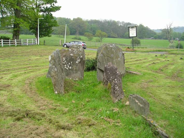
Gwernvale submitted by TheCaptain on 9th May 2004. Gwernvale, Chambered Tomb in Powys, SO211192
Looking into the remaining chamber, from the entrance passage way
(View photo, vote or add a comment)
Log Text: None
Gweal Hill, Bryher
Date Added: 11th Oct 2020
Site Type: Chambered Tomb
Country: England (Isles of Scilly)
Visited: Yes on 9th Sep 1986

Gweal Hill, Bryher submitted by paulcall on 22nd Oct 2007. This view looks south over the southwestern cairn of the three on Gweal Hill.
The central cist can be seen centre-left, and there are two rings of kerbs both of which can just be seen on this photo, although the whole mound is now greatly weathered by its position on the most westernmost point of the inhabited islands on Scilly.
(View photo, vote or add a comment)
Log Text: During a 2 week sailing trip with friends, we spent the day on Tresco then in the evening I rowed myself over to Bryher to have a look at the place and watch the sun go down from Gweal Hill
