Contributory members are able to log private notes and comments about each site
Sites theCAptain has logged on trip number: 203 (View all trips)
View this log as a table or view the most recent logs from everyone
Alignement de Lostmarc'h 1
Trip No.203 Entry No.495 Date Added: 27th May 2020
Site Type: Stone Row / Alignment
Country: France (Bretagne:Finistère (29))
Visited: Yes on 19th Jun 2005. My rating: Condition 3 Ambience 4 Access 3

Alignement de Lostmarc'h 1 submitted by thecaptain on 2nd Aug 2009. What I first found of the Lostmarc'h alignements, on top of a headland overlooking the Atlantic Ocean, was a line of stones running across the headland.
There are many other stones laying about, perhaps the remains of other rows.
(View photo, vote or add a comment)
Log Text: What I could find of the Lostmarc'h alignements, on top of a headland overlooking the Atlantic Ocean with a fine surf beach below to the south, was a line of eight stones aligned at an angle of 060°/240° running across the headland. None of the stones are much more than a metre in height, and they are spaced about 6 metres apart from each other. There are several other stones laying about, perhaps the remains of other rows.
Further out on the headland are a lot more stones at N48.2150° W4.5561°. Its hard to make out any clear pattern, but its possibly the remains of at least 4 rows. Further stones can be seen dotted about all over the place. Perhaps this was once a big important centre.
Oppidum de la Pointe de Lostmarc'h
Trip No.203 Entry No.496 Date Added: 27th May 2020
Site Type: Promontory Fort / Cliff Castle
Country: France (Bretagne:Finistère (29))
Visited: Yes on 19th Jun 2005. My rating: Condition 3 Ambience 4 Access 3

Oppidum de la Pointe de Lostmarc'h submitted by thecaptain on 1st Aug 2009. Just below the big Lostmarc'h headland with the alignements on top, there is a smaller headland which has been defended from the mainland by the creation of two rows of massive banks and ditches protecting it.
(View photo, vote or add a comment)
Log Text: Just below the big Lostmarc'h headland with the alignements on top, there is a smaller headland which has been defended from the mainland by the creation of two rows of massive banks and ditches protecting it.
On the headland apart from the inevitable remains of a chapel of some sort, there is also what appears to be the remains of some sort of cairn and burial chamber on the top. It wouldn't be unusual for one to be in such a place. There are 6 stones still sticking out of the ground here about 2.5 metres apart from each other, and stumps of others to be seen, which sort of make a rectangle inside a circular cairn.
It is very windblown here today, and misty which is a bit of a shame. The views would be tremendous on a clear day.
Dolmen de la Pointe de Lost Marc'h
Trip No.203 Entry No.497 Date Added: 27th May 2020
Site Type: Chambered Cairn
Country: France (Bretagne:Finistère (29))
Visited: Yes on 19th Jun 2005. My rating: Condition 2 Ambience 4 Access 3
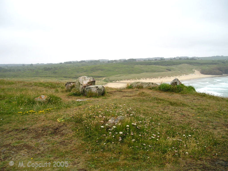
Dolmen de la Pointe de Lost Marc'h submitted by thecaptain on 1st Aug 2009. On the headland there is what appears to be the remains of some sort of cairn and burial chamber on the top. It wouldn't be unusual for one to be in such a place.
There are 6 stones still sticking out of the ground here, and stumps of others to be seen, which sort of make a rectangle inside a circular cairn.
(View photo, vote or add a comment)
Log Text: Just below the big Lostmarc'h headland with the alignements on top, there is a smaller headland which has been defended from the mainland by the creation of two rows of massive banks and ditches protecting it.
On the headland apart from the inevitable remains of a chapel of some sort, there is also what appears to be the remains of some sort of cairn and burial chamber on the top. It wouldnt be unusual for one to be in such a place. There are 6 stones still sticking out of the ground here about 2.5 metres apart from each other, and stumps of others to be seen, which sort of make a rectangle inside a circular cairn.
It is very windblown here today, and misty which is a bit of a shame. The views would be tremendous on a clear day.
Lagatjar alignements
Trip No.203 Entry No.498 Date Added: 27th May 2020
Site Type: Stone Row / Alignment
Country: France (Bretagne:Finistère (29))
Visited: Yes on 19th Jun 2005. My rating: Condition 4 Ambience 4 Access 5
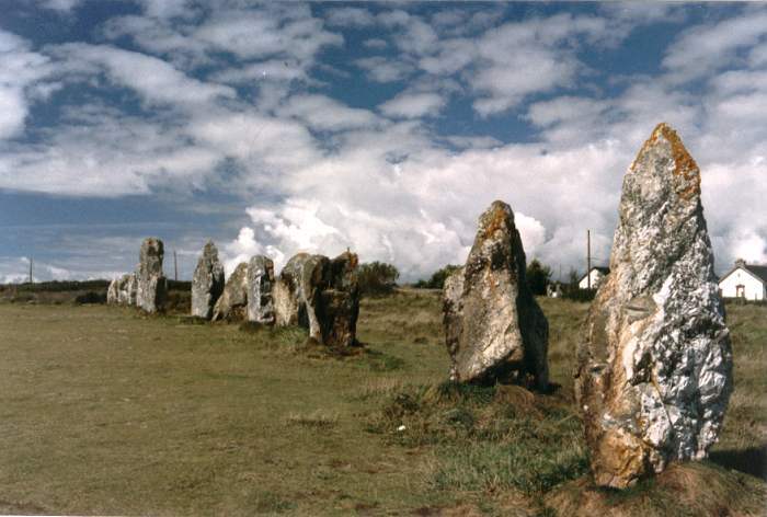
Lagatjar Alignements submitted by thecaptain on 18th Oct 2004. Lagatjar Alignements.
West of the fishing town of Camaret, in the far west of the Crozon Peninsula, Finisterre Brittany.
If memory serves me right, these stones form part of a sort of large stone square.
(View photo, vote or add a comment)
Log Text: The Lagatjar alignements are an intriguing arrangement of stones, mostly consisting of large white quartz blocks on open common land, just to the east of the fishing town of Camaret. There are probably over a hundred stones, mostly aligned into three lines, but there are some outliers as well.
The longest line is over 200 metres in length and has an orientation of 037°. From this line are two rows of larger blocks, heading off at right angles on bearing 317° for the northern row, which is approximately straight and 60 metres in length. The southern row is about 50 metres away, and heads off at 315°, but curves towards the west away from the baseline. Perhaps these two rows once joined up to form a horseshoe ?
South of the main line are three large grey stones, a single one at the west and a pair to the east. These three stones are aligned with each other. There are lots of orchids flowering here, which seems a bit late in the year.
Kerloas Menhir
Trip No.203 Entry No.499 Date Added: 27th May 2020
Site Type: Standing Stone (Menhir)
Country: France (Bretagne:Finistère (29))
Visited: Yes on 19th Jun 2005. My rating: Condition 5 Ambience 5 Access 4
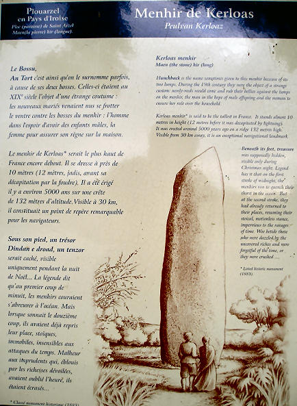
Kerloas menhir submitted by thecaptain on 23rd Jun 2006. Kerloas menhir noticeboard.
Unfortunately theres lots of writing, so it comes out very small !
(View photo, vote or add a comment)
Log Text: What a fantastic stone, and easily found near to the old D.5 road to the east of Plouarzel due to many signposts to it. This is the biggest standing menhir in Europe, if not the world, at nearly 10 metres tall, and has lost the top 2 metres after a lightning strike! It towers above all around, and standing as it does on top of a hill, it can be seen from 30 kilometres away.
The stone, which is not local and has been brought to this hilltop site from more than 2.5 kilometres away near the Aber Ildut estuary, has been beautifully shaped, and tapers both into the ground, and up to a point. On the two "thin" sides of the stone are round humps, about 20 cm in diameter about belly high above the ground.
This stone of course has many legends, such as treasure buried beneath it, going to drink at the ocean on the strike of 12:00 on Christmas night, and that newly wed couples should come here on their wedding night to rub the stone lumps for a good future and fertility. In fact, many wedding parties still come here to this day in order to perform this ritual.
It was a pity it was cold and late when I visited, and not good light for photographs. I feel I would like to stay here a while, it has a lovely atmosphere. Maybe I will come back tomorrow.
Kergadiou Menhirs
Trip No.203 Entry No.500 Date Added: 27th May 2020
Site Type: Standing Stones
Country: France (Bretagne:Finistère (29))
Visited: Yes on 20th Jun 2005. My rating: Condition 5 Ambience 4 Access 4

Kergadiou menhirs submitted by thecaptain on 8th Jul 2006. Kergadiou menhir 2 is another king sized menhir, 11 metres long, which unfortunately is not standing upright, but leaning at a very shallow angle.
It is perfectly smoothed into an extremely flat face on its upper surface, while the lower surface is still rough
(View photo, vote or add a comment)
Log Text: The two menhirs of Kergadiou are a fine place to visit, and fairly easily found in a field a couple of kilometres north of the Aber Ildut estuary. From these two giant menhirs, it is possible to see the Kerloas menhir when the modern trees are not in leaf, and the sightline over the Kerloas menhir is perpendicular to the midsummer sunrise. Coincidence ?
Kergadiou menhir 1 is a really magnificent monster menhir, 8.8 metres tall, and the most beautifully and perfectly smoothed and shaped menhir there is. Just 80 metres away to the northeast is its neighbour, another king sized menhir which unfortunately is not standing upright, but leaning at a very shallow angle. It is perfectly smoothed into an extremely flat face on its upper surface, while the lower surface is still rough, which leads to conjecture that it has perhaps never stood, and is left here unfinished. An alternate viewpoint is that it stood as a rough stone, and fell while being pounded into its smoothed and flattened shape, perhaps in preparation for some carvings. This menhir is 11 metres in length, so would have probably stood to the same height as its neighbour.
What a tremendous place.
Île Melon Dolmen
Trip No.203 Entry No.501 Date Added: 27th May 2020
Site Type: Burial Chamber or Dolmen
Country: France (Bretagne:Finistère (29))
Visited: Saw from a distance on 20th Jun 2005. My rating: Condition 3 Ambience 4 Access 2
Île Melon dolmen submitted by rw1 on 6th Mar 2008. 09/2007
(View photo, vote or add a comment)
Log Text: This is frustrating. There is only 15 metres of water between me and the island from where I sit, but the tide is coming in and the island is not going to get any nearer. The dolmen is on top of the island and looks a nice one, its capstone sitting on at least four support stones. There are also at least two menhirs further down to the south of the island, and looking towards the shore. Perhaps a swim is needed !
Île Melon menhirs
Trip No.203 Entry No.502 Date Added: 27th May 2020
Site Type: Standing Stones
Country: France (Bretagne:Finistère (29))
Visited: Yes on 20th Jun 2005. My rating: Condition 2 Ambience 5 Access 2
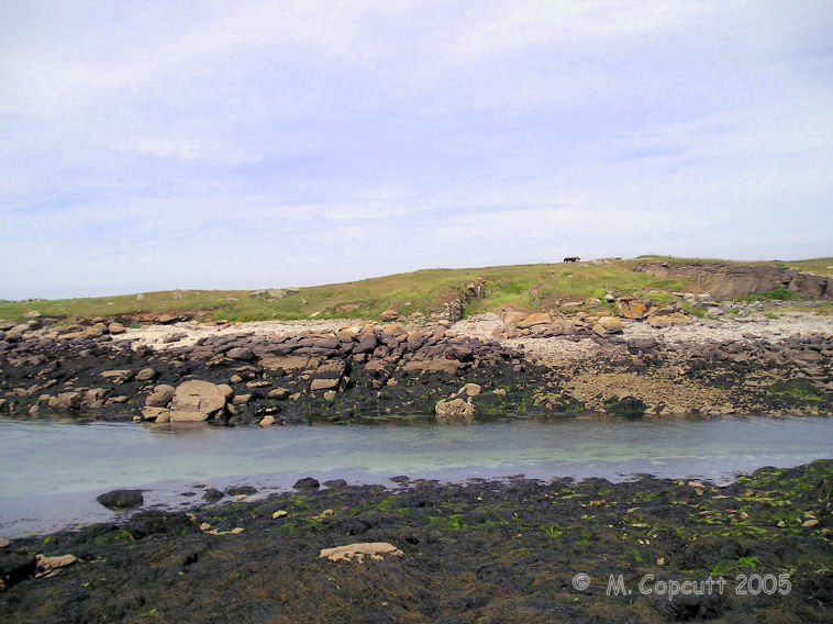
Île Melon menhirs submitted by thecaptain on 25th Jul 2009. View of Ile Melon from the end of the little harbour wall on the mainland.
The remains of two menhirs can be seen to the left of the picture, while the remaining dolmen is at the top of the island.
(View photo, vote or add a comment)
Log Text: This is frustrating. There is only 15 metres of water between me and the island from where I sit, but the tide is coming in and the island is not going to get any nearer. There is a dolmen on top of the island, and there are also at least two menhirs further down to the south of the island, and looking towards the shore. I believe that there was once a large menhir here also, which was blown up during the war. Perhaps a swim is needed !
Kerivoret Menhir
Trip No.203 Entry No.503 Date Added: 27th May 2020
Site Type: Standing Stone (Menhir)
Country: France (Bretagne:Finistère (29))
Visited: Yes on 20th Jun 2005. My rating: Condition 3 Ambience 3 Access 4
Kerivoret menhir submitted by theCaptain on 20th Jun 2014. About 50 metres away from the Kerivoret dolmen is a nice menhir, which looks to have been shaped with a slanted top. It's about 3.5 metres tall.
(View photo, vote or add a comment)
Log Text: About 50 metres away from the Kerivoret dolmen is a nice menhir, which looks to have been shaped with a slanted top. It's about 3.5 metres tall.
Kerivoret Dolmen
Trip No.203 Entry No.504 Date Added: 27th May 2020
Site Type: Burial Chamber or Dolmen
Country: France (Bretagne:Finistère (29))
Visited: Yes on 20th Jun 2005. My rating: Condition 4 Ambience 3 Access 4
Kerivoret dolmen submitted by theCaptain on 20th Jun 2014. This is a nice looking dolmen sitting in a pleasant field behind the houses. It is signposted from the road, and has a path to it from behind the houses, where there is room to park.
(View photo, vote or add a comment)
Log Text: This is a nice looking dolmen sitting in a pleasant field behind the houses. It is signposted from the roan, and has a path to it from behind the houses, where there is room to park. The chamber is about 3 metres long, less than 2 metres wide, and created with a good back stone and two large side slabs each side. There are other stones at the open end, perhaps an entry corridor or a broken front slab. The capstone is a nice piece of granite, and overhangs the sides considerably in places, being about 4 metres across in each direction.
Traonigou alignement de menhirs
Trip No.203 Entry No.505 Date Added: 27th May 2020
Site Type: Stone Row / Alignment
Country: France (Bretagne:Finistère (29))
Visited: Yes on 20th Jun 2005. My rating: Condition 3 Ambience 3 Access 5
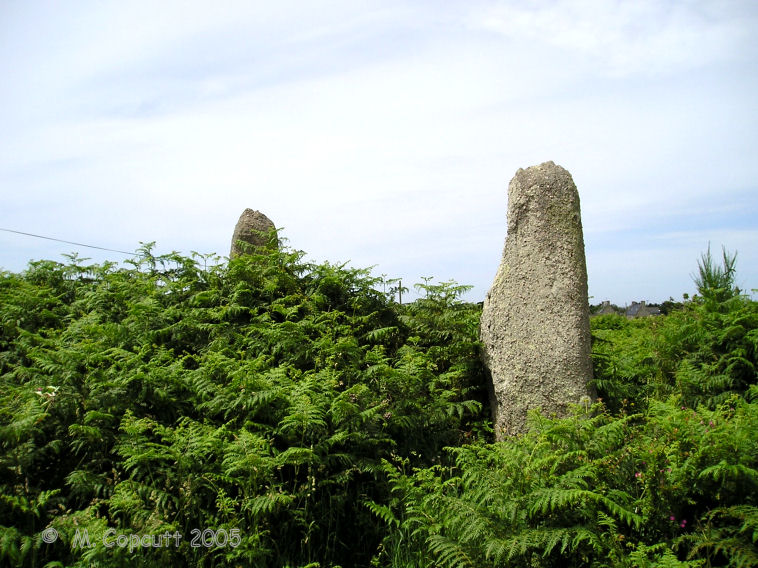
Traonigou alignement de menhirs submitted by thecaptain on 25th Jul 2009. The two standing menhirs are about 4 and 5 metres tall, the two fallen ones becoming lost in the undergrowth.
(View photo, vote or add a comment)
Log Text: Two fallen and two standing menhirs, which are supposedly aligned on the mid summer sunrise. The two standing menhirs are about 4 and 5 metres tall, the two fallen ones becoming lost in the undergrowth. These stones are signposted, and found just beside the road to the east of the hamlet of Traonigou.
Dolmen de Poulliot
Trip No.203 Entry No.506 Date Added: 27th May 2020
Site Type: Burial Chamber or Dolmen
Country: France (Bretagne:Finistère (29))
Visited: Yes on 20th Jun 2005. My rating: Condition 3 Ambience 3 Access 2

Dolmen de Poulliot submitted by thecaptain on 25th Jul 2009. Pleasant enough little dolmen sitting in a field of crops about 200 metres from the road.
(View photo, vote or add a comment)
Log Text: Pleasant enough little dolmen sitting in a field of crops about 200 metres from the road, but with a signpost. The capstone is sitting on three support stones, but I couldn’t get close enough to note any details.
Mezdoun menhirs
Trip No.203 Entry No.507 Date Added: 27th May 2020
Site Type: Standing Stones
Country: France (Bretagne:Finistère (29))
Visited: Yes on 20th Jun 2005. My rating: Condition 4 Ambience 3 Access 3
Mezdoun menhirs submitted by theCaptain on 2nd Feb 2012. The eastern of the two looks to have been broken and was possibly once much bigger.
(View photo, vote or add a comment)
Log Text: Two menhirs in a field of growing sweetcorn, so getting close enough to get details was not easy. These two menhirs are both between 4 and 5 metres tall, and have been shaped. The further east of the two looks to have been broken and was possibly once much bigger. They are about 60 metres from each other, on an east to west alignment.
Saint-Denec Alignement de Menhirs
Trip No.203 Entry No.508 Date Added: 27th May 2020
Site Type: Stone Row / Alignment
Country: France (Bretagne:Finistère (29))
Visited: Yes on 20th Jun 2005. My rating: Condition 3 Ambience 3 Access 5
Saint-Denec alignement de menhirs submitted by theCaptain on 31st Jan 2012. There is also a rather large menhir like stone laying at the foot of one of the menhirs, and there are other large stones laying in the fields nearby. I wonder if there was once a lot more here in the way of alignements?
On closer inspection of the fallen stone it can be seen that it has carvings on it. Two axes and a couple of the bishops crook shaped symbols (crosses). Not clearly seen in picture.
(View photo, vote or add a comment)
Log Text: The two St Dénec menhirs are standing in a field near to the farm of St Dénec. Both are about 3.5 to 4 metres high, but they are not nicely shaped and smoothed like most of the menhirs around here.
There is also a rather large menhir like stone laying at the foot of one of the menhirs, and there are other large stones laying in the fields nearby. I wonder if there was once a lot more here in the way of alignements?
On closer inspection of the fallen stone it can be seen that it has carvings on it. Two axes and a couple of the bishops crook shaped symbols (crosses). I was glad I went back for a second look after missing this first time round.
Menhir de Kerhouézel
Trip No.203 Entry No.509 Date Added: 27th May 2020
Site Type: Standing Stone (Menhir)
Country: France (Bretagne:Finistère (29))
Visited: Yes on 20th Jun 2005. My rating: Condition 5 Ambience 4 Access 4
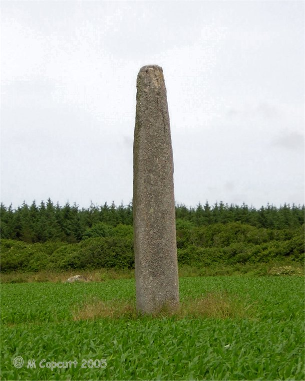
Menhir de Kerhouézel submitted by thecaptain on 24th Jul 2009. One of the Léon giants, the Kerhouézel menhir is a fantastic monster menhir, just inland from Porspoder. It must be nearly seven metres high and is fantastically smoothed and shaped.
Looking at these pictures now, several years after visiting, and they do not show the massive size, no do justice to this magnificent manhir. Truly a King of Léon.
(View photo, vote or add a comment)
Log Text: The Kerhouézel menhir is another fantastic monster menhir, just inland from Porspoder and signposted. It must be eight metres high and is fantastically smoothed and shaped. I just love these massive stones. I've go to give it a hug ! It is possible that there is a carved symbolon the upper part of the southern face.
Dolmen de Men-Milliget
Trip No.203 Entry No.510 Date Added: 27th May 2020
Site Type: Burial Chamber or Dolmen
Country: France (Bretagne:Finistère (29))
Visited: Yes on 20th Jun 2005. My rating: Condition 3 Ambience 3 Access 4
Dolmen de Men-Milliget submitted by theCaptain on 4th Feb 2012. It's chamber is made with a large backstone and two side slabs, with remains of other stones, but it is partially buried in the dunes.
(View photo, vote or add a comment)
Log Text: Men Milliget or the St Gonvel dolmen is a pleasant little dolmen living on the landward side of a headland sticking out into the ocean. It's 3 metre by 2 metre chamber is made with a large backstone and two side slabs, with remains of other stones, but it is partially buried in the dunes. The strangely shaped capstone is known as Men Milliget (Roche Maudite, Bad rock).
Saint-Gonvarc'h menhir
Trip No.203 Entry No.511 Date Added: 27th May 2020
Site Type: Standing Stone (Menhir)
Country: France (Bretagne:Finistère (29))
Visited: Saw from a distance on 20th Jun 2005. My rating: Condition 5 Ambience 3 Access 2
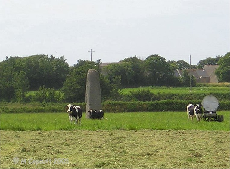
Saint-Gonvarc'h menhir submitted by thecaptain on 24th Jul 2009. The Pierre de St Gonvarc'h, or Mez menhir, can be seen across a couple of fields, and is another of the monster menhirs of the Léon region (Kings of Léon?).
Seen here from road along the "uphill" side.
(View photo, vote or add a comment)
Log Text: The Pierre de St Gonvarc'h, or Mez menhir, can be seen across a couple of fields, and is another of the monster menhirs of this region (Leon). Comparing it to a nearby cow for size, it must be a good 6 metres tall, and has been beautifully shaped.
Pointe de Guilligui allée couverte
Trip No.203 Entry No.512 Date Added: 27th May 2020
Site Type: Passage Grave
Country: France (Bretagne:Finistère (29))
Visited: Yes on 20th Jun 2005. My rating: Condition 4 Ambience 4 Access 4
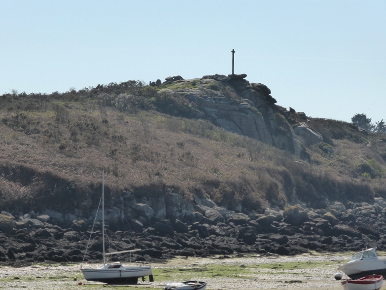
Pointe de Guilligui allée couverte submitted by theCaptain on 21st Apr 2014. Pointe de Guilligui allée couverte seen in its hilltop position from across the bay, on the quay at Portsall.
(View photo, vote or add a comment)
Log Text: This is an unusual allée couverte, not quite at the top of the Guilliguy headland, overlooking the ocean where the Amoco Cadiz was wrecked, and the little port of Portsall. This is a place which has been revered over the millennia, and still serves as a place for thought by the big cross, and the views are fantastic.
The allée couverte was built in the neolithic, but much altered during the bronze age. It is now an L shaped tomb, the main part being 6 metres long by 2 metres wide with a couple of capstones still in place. At the eastern end an extra chamber has been built onto the south side, about 4 metres in length and still with one capstone. There is a nicely carved entrance stone between the two. It looks to me like the main chamber has been shortened here when this extra chamber was made, and a couple of stones still survive to the east.
Menhir du Guilligui
Trip No.203 Entry No.513 Date Added: 27th May 2020
Site Type: Standing Stone (Menhir)
Country: France (Bretagne:Finistère (29))
Visited: Yes on 20th Jun 2005. My rating: Condition 3 Ambience 3 Access 4
Menhir du Guilligui submitted by theCaptain on 20th Jun 2012. About 60 metres to the east of the Guilliguy headland and dolmen, is a little menhir, about 1.5 metres in height.
The well known burial chamber can be seen on the headland beside the cross.
(View photo, vote or add a comment)
Log Text: About 60 metres to the east of the Guilliguy headland and dolmen, is a little menhir, about 1.5 metres in height.
Île Carn cairn
Trip No.203 Entry No.514 Date Added: 27th May 2020
Site Type: Chambered Cairn
Country: France (Bretagne:Finistère (29))
Visited: Saw from a distance on 20th Jun 2005. My rating: Access 2
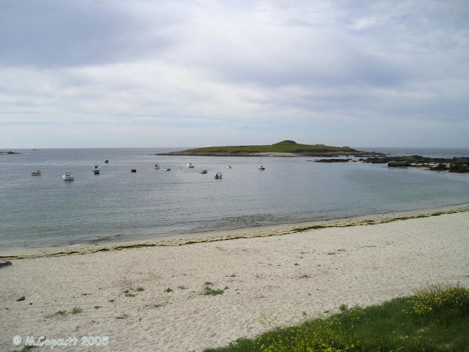
Île Carn cairn submitted by thecaptain on 15th Jun 2006. Île Carn, just off the northwestern coast of Brittany.
Unfortunately, when I was passing here the tide was not fully out, and rising, so I could not get out onto the little island with its massive and spectacular cairn.
I tried stopping nearby for the night, which would have let me get out onto the island next morning, but the local campsite was closed and deserted, and I had worldly needs, so had to move on elsewhere, still hoping to come back the next morning.......
(View photo, vote or add a comment)
Log Text: Just offshore is this little island which can be reached a low tide, with a massive cairn containing three dolmenic chambers. There are also some WW2 gun emplacements and lookouts which spoil it a bit. The cairn is massive, and looks like its been quarried into, and from the shore the entry to one of the chambers can be seen. Its a pity I cannot get out to have a look. Should I borrow a boat ?
