Contributory members are able to log private notes and comments about each site
Sites theCAptain has logged. View this log as a table or view the most recent logs from everyone
Dolmen du Pech (Cazals)
Trip No.205 Entry No.36 Date Added: 19th Oct 2020
Site Type: Burial Chamber or Dolmen
Country: France (Midi:Tarn-et-Garonne (82))
Visited: Yes on 2nd Sep 2005. My rating: Condition 5 Ambience 3 Access 5

Dolmen du Pech (Cazals) submitted by thecaptain on 17th Jan 2006. View from the western end of the weird Box Tomb of Pech, perhaps over-enthusiastically restored in 1992.
The dimensions of the stone mound are about 10 metres wide by 25 metres long. The back, western, end is curved and not squared.
(View photo, vote or add a comment)
Log Text: Despite not being marked on any ign maps I have seen, this box tomb dolmen is easily found as it is right beside the D.75B between Bourdoncle and Doumerc by the road to Frau. Subject of an excavation in 1989, and reconstruction in 1992, it is now fenced in, presumably for protection, but it looks terribly ugly because of that.
The chamber seems to be of a double type, open to the east, with a large first chamber 4.5 metres by 2.5 metres between two large side slabs, followed by the smaller chamber between side slabs one metre apart. A single large capstone covers the back chamber and a part of the first, and there is a secondary loose stone structure on the top, covering the capstone. The front of the chamber is walled off from the outside. The odd thing about this dolmen is the rectangular mound it is contained within, which has been subject to a perhaps over-enthusiastic reconstruction. There are other rectangular tombs like this, especially in this locality, but somehow this seems too regular and uniform. The dimensions of the stone mound are about 10 metres wide by 25 metres long. The back, western, end is curved and not squared. The whole thing is most odd.
While reversing to try and park the van here, I completely missed seeing a roadsign and flattened the thing completely - luckily it was only loosely held in the ground and did no damage, and was easy to stand up again !
Tombe du Géant (Septfonds)
Trip No.205 Entry No.35 Date Added: 19th Oct 2020
Site Type: Burial Chamber or Dolmen
Country: France (Midi:Tarn-et-Garonne (82))
Visited: Yes on 2nd Sep 2005. My rating: Condition 4 Ambience 4 Access 3

Tombe du Géant (Septfonds) submitted by thecaptain on 25th Jan 2006. This dolmen is a nice one, still partially within its mound. The chamber is made with two long side slabs, each 5 metres in length, and with a nicely shaped and fitted backstone between them. The capstone has broken, and only half of it now remains.
(View photo, vote or add a comment)
Log Text: The Tombe du Géant is a scheduled historic monument, and as such it is marked on the local maps, both 1:25,000 and 1:100,000, near to the farm of Les Tombes to the southeast of Septfonds. It is however not so easy to find in the real world, with the fields and indeed many of the trackways in this area having recently been thoroughly fenced off, with both barbed wire and electric fences, and new hedges planted. At first, I could find no way through to this dolmen, and as it is in a bit of woodland, there was no way I could see anything from nearby either. Before giving up totally, I thought I would try an approach from a different angle, and indeed, there is a new trackway made, which takes one around the newly fenced off land. It is complex to describe, but starting from a point well to the south of where the dolmen is marked, take the signed PR.1 footpath firstly to the east for a couple of hundred metres, and then having passed the end of the first field and passed into some woods, turn left to the north and follow the trackway for about 500 metres where you will then find the Tombe du Géant in the woodland to the left of the path.
The dolmen is a nice one, still partially within its mound. The chamber is made with two long side slabs, each 5 metres in length, and with a nicely shaped and fitted backstone between them. The capstone has broken, and only half of it now remains. The chamber is 4.5 metres long by 1.5 metres wide internally, and as usual faces to the east. This would be a very pleasant spot, but for all the flies buzzing around and the humming and crackling power lines passing almost directly overhead. There are probably several other dolmens to be found in the locality, judging by certain names on the maps.
Dolmen de Caux-Vieilles
Trip No.205 Entry No.32 Date Added: 19th Oct 2020
Site Type: Burial Chamber or Dolmen
Country: France (Midi:Tarn-et-Garonne (82))
Visited: Yes on 2nd Sep 2005. My rating: Condition 2 Ambience 3 Access 4

Dolmen de Caux-Vieilles submitted by TheCaptain on 6th Nov 2007. A bit to the south of the track running along the southern edge of the airfield, in the scrubland, are several mounds of stones.
One of these mounds has a clear dolmen chamber within it, but was very difficult to photograph with all the trees and bushes around it.
I am lead to believe that there are many dolmens to be found within these woodlands, far more than the three that I found.
(View photo, vote or add a comment)
Log Text: A bit to the south of the track running along the southern edge of the airfield, in the scrubland, are several mounds of stones. One of these mounds has a clear dolmen chamber within it, 3 metres in length by 1.5 metres in width. It consists of two side slabs and a backstone between them, but no capstone. The northern half of the mound still exists right up to the top of the side support, while the southern part is mostly missing. This chamber is very difficult to photograph with all the trees and bushes around it. I am lead to believe that there are many dolmens to be found within these woodlands, far more than the three that I found.
Finelle Dolmen
Trip No.205 Entry No.31 Date Added: 19th Oct 2020
Site Type: Burial Chamber or Dolmen
Country: France (Midi:Tarn-et-Garonne (82))
Visited: Yes on 2nd Sep 2005. My rating: Condition 4 Ambience 3 Access 4
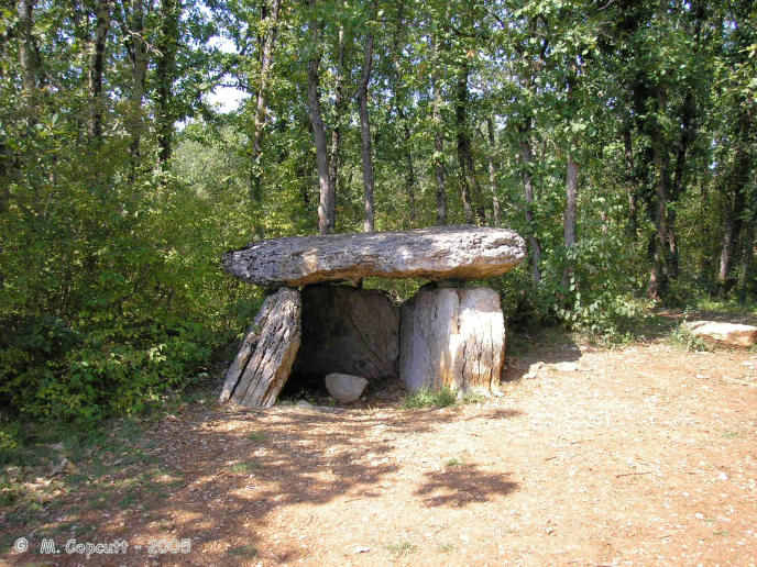
Finelle Dolmen submitted by TheCaptain on 6th Nov 2007. A bit to the west along the track running along the southern edge of the airfield, and you soon come to another dolmen.
This one has lost its mound, which has no doubt been used to build the local walls, and it is standing proud at the edge of a flat area used for dumping rubble etc.
(View photo, vote or add a comment)
Log Text: A bit to the west of the first dolmen, along the track running along the southern edge of the airfield, and you soon come to another dolmen. This one has lost its mound, which has no doubt been used to build the local walls, and it is standing proud at the edge of a flat area used for dumping rubble etc. Its a fairly standard southern French dolmen, with two 4 metre long sideslabs and a backstone between them, topped with a capstone, making a chamber 3 metres by 2 metres. There is some evidence of a front closing stone, and the chamber faces eastwards on a bearing of 095°.
Dolmen de Peyrelevade (Septfonds)
Trip No.205 Entry No.30 Date Added: 19th Oct 2020
Site Type: Burial Chamber or Dolmen
Country: France (Midi:Tarn-et-Garonne (82))
Visited: Yes on 2nd Sep 2005. My rating: Condition 3 Ambience 3 Access 5

Dolmen de Peyrelevade (Septfonds) submitted by TheCaptain on 6th Nov 2007. Right beside the track is the first dolmen you come to. It is still mostly within its mound of loose stone, and quite a large one.
(View photo, vote or add a comment)
Log Text: To the west of the village of Septfonds, and to the south of the little airfield are several dolmens in the woodlands. There are signposts to "dolmens" and down a little track is a parking place and more signs. Right beside this track is the first dolmen you come to. It is still mostly within its mound of loose stone, and quite a large one. The 5 metres by 4 metres capstone sits on top of a chamber 4 metres in length, by 2 metres wide, made with the usual 2 large sideslabs and a back stone, but these stones are completely below ground level. The chamber opens to the east, on a bearing of about 080°. To the west of the main dolmen are a couple of other long side set slabs near to the roadside, where the mound has been cut away. Perhaps this is the remains of a secondary burial chamber ? The mound diameter is about 15 metres. There are lots of strange red topped mushrooms / toadstools poking up through the ground here. Very interesting.
Puy de Pauliac Cromlech
Trip No.205 Entry No.27 Date Added: 19th Oct 2020
Site Type: Stone Circle
Country: France (Limousin:Corrèze (19))
Visited: Yes on 1st Sep 2005. My rating: Condition 4 Ambience 4 Access 4
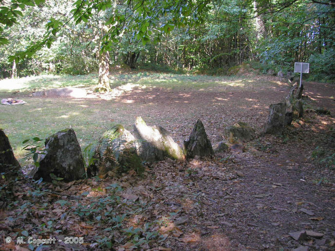
Puy de Pauliac Cromlech submitted by thecaptain on 17th Feb 2006. In a clearing on the forest covered slopes, the cromlech is made with many stones, nearly all less than a metre tall, set up almost touching each other making an enclosure which is a sort of rounded square about 40 to 50 metres across.
(View photo, vote or add a comment)
Log Text: At the top of the lovely Puy de Pauliac hill to the east of the historical village of Aubazines, is an orientation table, and fantastic views stretching for many miles in nearly all directions, with the high point of the Massif Central, the Puy de Sancy to be seen way off in the east. Near to the top of this hill is marked a cromlech, and I almost didn't find it. The cromlech can be found a bit downhill to the north of the summit, and it is signposted, although the tiny little wooden sign is easily missed, hiding in the woodland.
In a clearing in the forest covered slopes, the cromlech is made with many stones, nearly all less than a metre tall, set up almost touching each other making an enclosure which is a sort of rounded square about 40 to 50 metres across. At the southern, upslope side, is a large outcrop of natural rocks, probably 10 to 15 metres high from which the cromlech extends, joining between other significant natural rocks, to close off the area.
It is very easy to imagine a gathering of people here, with the leader stood on top of the large natural rocks giving his sermon. Within the cromlech are several nicely weathered natural granite slabs, one of which has a large break in it. These would make good seats for the best view !
Dolmen de Rochesseux
Trip No.205 Entry No.26 Date Added: 19th Oct 2020
Site Type: Burial Chamber or Dolmen
Country: France (Limousin:Corrèze (19))
Visited: Yes on 1st Sep 2005. My rating: Condition 4 Ambience 4 Access 4

Dolmen de Rochesseux submitted by thecaptain on 15th Feb 2006. This little dolmen is found in a sort of parkland high up on the slopes of Puy de Pauliac, above the historical village of Aubazines in Corrèze.
(View photo, vote or add a comment)
Log Text: This little dolmen is found in a sort of parkland high up on the slopes of Puy de Pauliac, above the historical village of Aubazines. It is signposted from the road. A triangular 3 metres by 2 metres capstone sits delicately balanced on top of two side support stones and a back stone, with a chamber 2.5 metres long by 1 metre wide underneath. The two side stones are both pointed at the top, and the capstone sits only on their points, and the small backstone almost at the same place, overhanging substantially in all directions. The chamber faces eastwards, at a bearing of 080°. The capstone has a lovely ring to it when knocked.
Estivaux Dolmen
Trip No.205 Entry No.25 Date Added: 19th Oct 2020
Site Type: Burial Chamber or Dolmen
Country: France (Limousin:Corrèze (19))
Visited: Yes on 1st Sep 2005. My rating: Condition 3 Ambience 3 Access 4

Estivaux dolmen submitted by thecaptain on 13th Feb 2006. To the east of the village of Estivaux, this dolmen can be found in a field near to the sports stadium and a new housing development, just about 50 metres from the road.
(View photo, vote or add a comment)
Log Text: To the east of the village of Estivaux, this dolmen can be found in a field near to the sports stadium and a new housing development, just about 50 metres from the road. Its an odd little affair, and almost looks modern. The oval capstone, 3.5 m by 2.5 m sits on top of 4 support stones making a small chamber 2 metres by 1 metre inside, and about 1.5 metres in height. The support stones look to me to be quite new, perhaps an enthusiastic restoration job has been done, and it is all a bit too level. Unfortunately two of the support stones have been painted blue, and the ambience of the place is spoiled by the power cables directly overhead.
Dolmen dit La Maison du Loup
Trip No.205 Entry No.24 Date Added: 19th Oct 2020
Site Type: Burial Chamber or Dolmen
Country: France (Limousin:Corrèze (19))
Visited: Yes on 1st Sep 2005. My rating: Condition 3 Ambience 4 Access 3

Dolmen dit La Maison du Loup submitted by thecaptain on 13th Feb 2006. This dolmen is found in thick woodland on the end of a defended headland overlooking the Vézère river, and is at the top of a cliff edge. The dolmen is in part made from natural rocks, with a couple of sideslabs and a capstone (now broken into two pieces) resting on a rocky outcrop.
(View photo, vote or add a comment)
Log Text: About a kilometre from the village of Espartignac, this dolmen can be found along a signposted track from the village square near to the Bar Le Dolmen. It is found in thick woodland on the end of a defended headland overlooking the Vézère river, and is at the top of a cliff edge. The dolmen is in part made from natural rocks, with a couple of sideslabs and a capstone (now broken into two pieces) resting on a rocky outcrop. The capstone is about 3 metres by 2 metres, and sits about 2 metres above the floor of the chamber.
The headland has been fortified for many hundreds of years, perhaps even thousands. But what can be seen today, with a Motte surrounded by another flat and defended area, dates to post Roman times. There are also double ditches and banks at the south to defend from the landward side of the headland not surrounded by the river. This place is at the site of an important ford across the Vézère river, on the important route from northern France to the Mediterranean.
Dyrham Camp
Date Added: 17th Oct 2020
Site Type: Hillfort
Country: England (Gloucestershire)
Visited: Yes on 9th Sep 2007
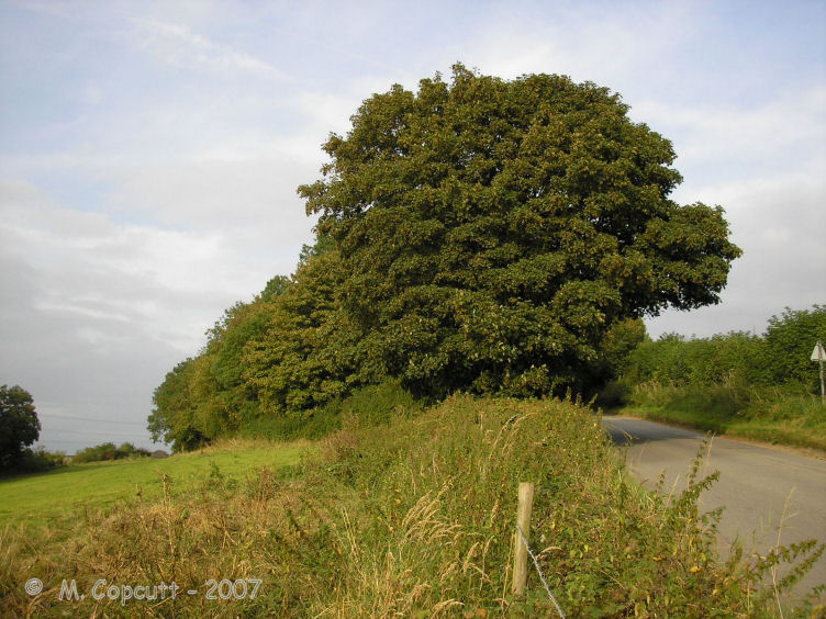
Dyrham Camp submitted by thecaptain on 28th Aug 2008. The western "point" of Hinton Hillfort, where it is cut into two by the little road up the hillside from the village of Hinton below.
(View photo, vote or add a comment)
Log Text: Dyrham Camp, otherwise known as Hinton Hillfort, is not so much a hillfort, but more a promontary fort, on a southwest facing spur of the Cotswold Hills north of Bath. Basically triangular in shape, it is cut into two by the little road up the hillside from the village of Hinton below. The northern part is mostly in woodland, and seems to be used as a rubbish dump these days. The hill edge has been shaped, and in places the bank and ditch is in fine condition, perhaps kept in shape in more recent times for drainage. The southern half of the fort is open pasture with a public footpath running through, and the steep southern slopes are sort of terraced, with several almost cliff like ramparts, below which are quite spectacular remains of ancient field systems. The eastern edge of the fort, where the land is flat on top of the Cotswold plateau, has a large ditch and bank in place across the headland. The ditch is about 10 metres wide and 2 metres deep, with a bank up to 4 metres high on the inside, which even these days is a fairly good barrier to entry.
Dyrham Camp
Date Added: 17th Oct 2020
Site Type: Hillfort
Country: England (Gloucestershire)
Visited: Yes on 9th Oct 2020
Dyrham Camp submitted by Thorgrim on 22nd Aug 2003. Dyrham Camp, otherwise known as Hinton Hillfort, is best seen from high land in Dyrham Park (National Trust) Dating from the Iron Age, it was the likely site of the Battle of Dyrham in 577 AD when the Anglo-Saxon Chronicle tells us that the invading Saxons under "Cuthwine and Ceawlin fought against the Britons and slew three kings, Coinmail, Condidan and Farimail at the place which is called Dyrham; and they captured three cities, Gloucester, Cirencester and Bath"
(View photo, vote or add a comment)
Log Text: Walking a loop on the Cotswold Way around Dyrham and Tormarton, see Hinton Hillfort from the southern side in the fading autumn sunlight.
Golden Cap Barrows
Date Added: 16th Oct 2020
Site Type: Barrow Cemetery
Country: England (Dorset)
Visited: Yes on 15th Oct 2020. My rating: Condition 2 Ambience 5 Access 3
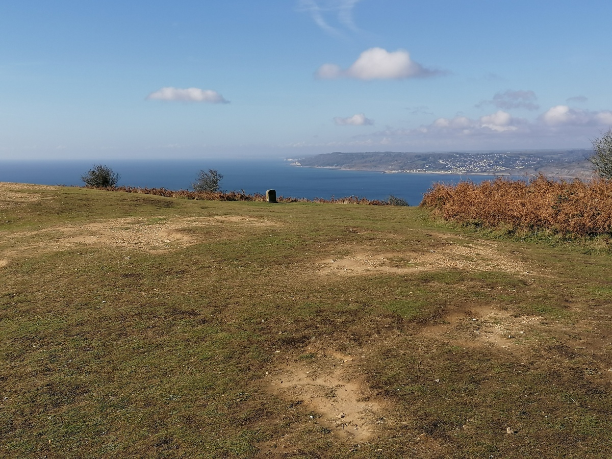
Golden Cap Barrows submitted by TheCaptain on 22nd Oct 2020. Remains of 5 barrows can be seen on Golden Cap summit, the highest point on the British south coast.
The inland barrows viewed here looking westwards towards Lyme Regis and Beer Head beyond.
(View photo, vote or add a comment)
Log Text: Visit on a walk from Seatown up the coast path up and over the Golden Cap and around Stanton St Gabriel and back. Remains of 5 barrows can be seen on the open hilltop to the west of the highest point of 191m, the highest point on the British south coast. They are in a line along the top, but now very low and worn, clearly showing the Chert and gravelly golden sandstone of which they are constructed.
Bras Dolmen
Trip No.205 Entry No.23 Date Added: 14th Oct 2020
Site Type: Burial Chamber or Dolmen
Country: France (Limousin:Haute-Vienne (87))
Visited: Yes on 31st Aug 2005. My rating: Condition 5 Ambience 5 Access 4
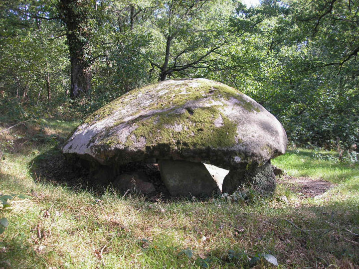
Bras dolmen submitted by thecaptain on 7th Oct 2005. Bras dolmen, near the village of Saint-Sulpice-les-Feuilles.
A little cracker.
(View photo, vote or add a comment)
Log Text: This beautiful little dolmen is fairly easily found to the south of the village of Saint-Sulpice-les-Feuilles along the D.44 road. Just to the north of where the road crosses the river Benaize is a place to park and a signposted footpath to the west. The footpath is well marked with orange marks, and after a couple of hundred metres walk turn right and go up the hill for a further hundred metres.
The dolmen has a rectangular chamber, 3.5 metres by 2 metres, built on the hillside overlooking the river, and it is open to the south. The single granite capstone is 4 metres long by 3 metres wide, and a lovely curved shape, looking from certain directions like an elongated mushroom. It sits on top of seven support stones, with a couple more fallen below it. There are remains of a mound around it, circular and approximately 15 metres in diameter. It is possible that there was once an entry passage, as there are signs of side set slabs on the down slope from the dolmen. The stones here are covered with lots of nice moss. This is such a nice dolmen I was inspired to try and do a little drawing or two.
Pierre Levée au Bois Bouéry
Trip No.205 Entry No.21 Date Added: 14th Oct 2020
Site Type: Burial Chamber or Dolmen
Country: France (Limousin:Haute-Vienne (87))
Visited: Yes on 31st Aug 2005. My rating: Condition 5 Ambience 5 Access 4
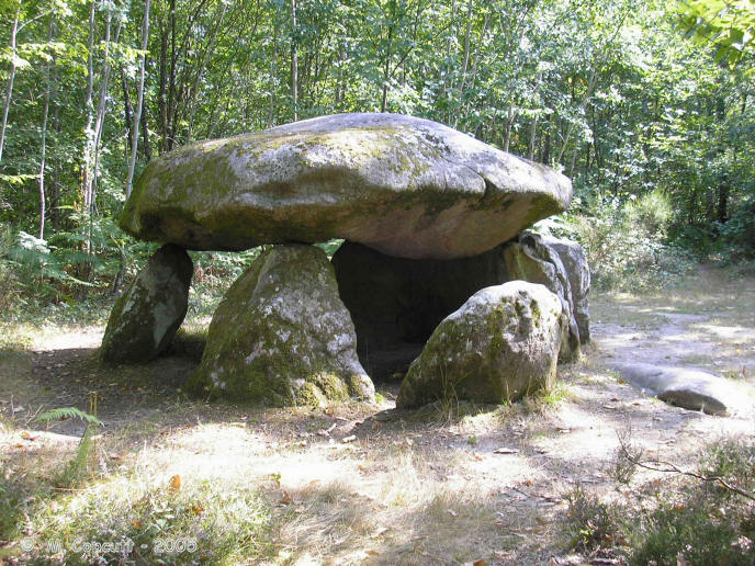
Pierre Levée au Bois Bouéry submitted by thecaptain on 20th Feb 2006. In the forest to the southwest of Saint-Sulpice-les-Feuilles, this lovely dolmen is easily found as it is signposted from the D.2 road, and it resides in a little forest clearing.
(View photo, vote or add a comment)
Log Text: In the forest to the southwest of Saint-Sulpice-les-Feuilles, this dolmen is easily found as it is signposted from the D.2 road, several kilometres to the north. From the road that leads to the dolmen, it is just a hundred metres walk from a parking place, and it resides in a little forest clearing.
The dolmen is quite a big one, made from granite rocks. The capstone is sort of mushroom shaped, and about 5 metres in diameter. It sits on top of 5 support stones, with at least one other fallen, and is about 1.5 metres off the ground. It covers an oval shaped chamber 4 metres by 3 metres internal dimensions with the probable entrance to the east. The support stone at the northern side appears to have engravings on it, and I would put money on the markings not being natural. Near to the ground is a classic palette about 40 cm long pointing towards the right, and above this a classic necklace and breasts, or else a smiley face. I have not seen any reference to there being carvings here.
Marchain Dolmen
Trip No.205 Entry No.20 Date Added: 14th Oct 2020
Site Type: Burial Chamber or Dolmen
Country: France (Poitou:Vienne (86))
Visited: Yes on 31st Aug 2005. My rating: Condition 3 Ambience 3 Access 2

Marchain dolmen submitted by thecaptain on 11th Feb 2006. To the west of the village of Lathus-Saint-Rémy, in the fields near to the hamlet of Marchain, can be found this dolmen. It can be seen across the fields by the crossroads to the south of the hamlet, but I could find no obvious way to get to the dolmen, all the fields being fenced off.
(View photo, vote or add a comment)
Log Text: To the west of the village of Lathus-Saint-Rémy, in the fields near to the hamlet of Marchain, can be found this dolmen. It can be seen across the fields by the crossroads to the south of the hamlet, but I could find no obvious way to get to the dolmen, all the fields being fenced off. It looks to be a fairly simple little dolmen, with a capstone set on top of a few support stones.
Dolmen dit Pierre-Soupèze
Trip No.205 Entry No.18 Date Added: 14th Oct 2020
Site Type: Burial Chamber or Dolmen
Country: France (Poitou:Vienne (86))
Visited: Yes on 31st Aug 2005. My rating: Condition 3 Ambience 3 Access 2

Dolmen dit Pierre-Soupèze submitted by thecaptain on 11th Feb 2006. To the southeast of Montmorillon, this dolmen is within a ploughed field, which is very well fenced to keep people out.
From the edge of the farm lane you can see a few stones under some bushes, with a large capstone at an angle on top of a couple of supports.
(View photo, vote or add a comment)
Log Text: To the southeast of Montmorillon, this dolmen is within a ploughed field, which is very well fenced to keep people out. From the edge of the farm lane you can see a few stones under some bushes, with a large capstone at an angle on top of a couple of supports. From certain angles daylight can be seen beneath it. It is possible that there are two dolmen capstones here, or else there are many other large stones dumped here for field clearance.
Dolmen de la Bastière 2
Trip No.205 Entry No.17 Date Added: 14th Oct 2020
Site Type: Burial Chamber or Dolmen
Country: France (Poitou:Vienne (86))
Visited: Yes on 31st Aug 2005. My rating: Condition 2 Ambience 3 Access 4
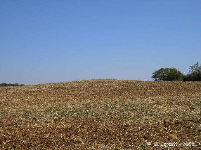
Dolmen de la Bastière 2 submitted by thecaptain on 10th Feb 2006. the fields round here have several mounds and piles of stones, which are perhaps the remains of half a dozen dolmens or burial mounds.
Without any more details, I find it hard to know just what is the historical monument dolmen. Perhaps its none of these mounds I saw, and is hiding in a hedge or the very thick woodland nearby.
(View photo, vote or add a comment)
Log Text: Marked on my ign 1:100,000 map is a dolmen in the field to the south of the road between Lussac and Montmorillon. I had a good look around, but could find no obvious dolmen to which it referred. However the fields round here have several mounds and piles of stones, which are perhaps the remains of half a dozen dolmens or burial mounds, some of which have since been used to pile up other stones for field clearance purposes, some of which have been ploughed out. Without any more details, I find it hard to know just what is the historical monument dolmen. Perhaps its none of these mounds I saw, and is hiding in a hedge or the very thick woodland nearby.
On seeing a more detailed map later in the day, the dolmen is probably a bit further from the road, into the woodland at the far side of the field, to where I had walked. Damn.
Dolmen de la Bastière 1
Trip No.205 Entry No.16 Date Added: 14th Oct 2020
Site Type: Burial Chamber or Dolmen
Country: France (Poitou:Vienne (86))
Visited: Yes on 31st Aug 2005. My rating: Condition 2 Ambience 3 Access 4

Dolmen de la Bastière 1 submitted by thecaptain on 10th Feb 2006. There is a registered historic monument dolmen somewhere to the south of the road between Lussac and Montmorillon. I had a good look around, but could find no obvious dolmen.
However the fields round here have several mounds and piles of stones, which are perhaps the remains of half a dozen dolmens or burial mounds.
(View photo, vote or add a comment)
Log Text: Marked on my ign 1:100,000 map is a dolmen in the field to the south of the road between Lussac and Montmorillon. I had a good look around, but could find no obvious dolmen to which it referred. However the fields round here have several mounds and piles of stones, which are perhaps the remains of half a dozen dolmens or burial mounds, some of which have since been used to pile up other stones for field clearance purposes, some of which have been ploughed out.
Without any more details, I find it hard to know just what is the historical monument dolmen. Perhaps its none of these mounds I saw, and is hiding in a hedge or the very thick woodland nearby. On seeing a more detailed map later in the day, the dolmen is probably a bit further from the road, into the woodland at the far side of the field, to where I had walked. Damn.
Dolmen de Loubressac
Trip No.205 Entry No.15 Date Added: 14th Oct 2020
Site Type: Burial Chamber or Dolmen
Country: France (Poitou:Vienne (86))
Visited: Yes on 31st Aug 2005. My rating: Condition 3 Ambience 3 Access 5
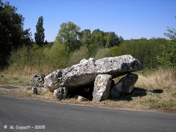
Dolmen de Loubressac submitted by thecaptain on 19th Feb 2006. At the hamlet of Loubressac, the little road curves around the remains of this dolmen.
The capstone, which once would have measured 5 metres by 4 metres, has now broken and collapsed into the chamber.
(View photo, vote or add a comment)
Log Text: Beside the river Goberté to the west of Lussac-les-Chateaux, at the hamlet of Loubressac, the little road curves around the remains of this dolmen. It is now sitting right beside the road at the edge of a pond. The capstone, which once would have measured 5 metres by 4 metres, has now broken and collapsed into the chamber. About 8 or 10 support stones remain, many of which have fallen. The entrance is to the east. Most of the stones are of the local white limestone, with holes and depressions everywhere, but the large support stone at the back of the chamber is a dark granite rock.
Unfortunately there is a telephone inspection cover right beside the dolmen which detracts. While here there was a helicopter flying very low overhead, perhaps checking on the overhead power lines.
Verrières Dolmen
Trip No.205 Entry No.13 Date Added: 13th Oct 2020
Site Type: Burial Chamber or Dolmen
Country: France (Poitou:Vienne (86))
Visited: Yes on 30th Aug 2005. My rating: Condition 2 Ambience 3 Access 4
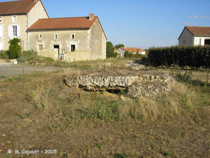
Verrières dolmen submitted by thecaptain on 19th Feb 2006. Just outside the village of Verrières, to the south by the road to Lussac-les-Chateaux, are the remains of this dolmen, which can be found round the back of some houses at the top of the valley.
(View photo, vote or add a comment)
Log Text: Just outside the village of Verrières, to the south by the road to Lussac-les-Chateaux, are the remains of this dolmen, which can be found round the back of some houses at the top of the valley. Its not much more than a large slab of rock sitting on the ground these days, which is the capstone which measures 4 metres by 3 metres, with a few bits of crumbled rock underneath. There are no signs of any obvious support stones.
When I got back to my van after visiting this, the antitheft electronics would not turn off, and so nothing would start. I checked to see if anything obvious was loose, but could find nothing. I checked the other keys and that didn't help. I asked a passing man in a pickup truck if he could help, and he got a bloke from a garage out to help me. He had a look, but couldn't really do anything till tomorrow, when he could get the van to the garage with the necessary electronics gear. We pushed the van down into a little side lane where I could stay overnight, and he promised that he or someone else from the garage who could speak some English would be back in the morning about 8:30. This is just what I always dreaded would happen.
