Contributory members are able to log private notes and comments about each site
Sites theCAptain has logged. View this log as a table or view the most recent logs from everyone
Bois du Mont
Date Added: 29th Oct 2019
Site Type: Passage Grave
Country: France (Normandie:Manche (50))
Visited: Yes on 16th Oct 2010
Bois du Mont submitted by TheCaptain on 16th Oct 2010. Remains of an Allée Couverte can be found in the private woodlands of Bois du Mont which is to the southwest of the village of Lithaire.
Info and picture from the site board at Bois de la Plesse.
(View photo, vote or add a comment)
Log Text: None
Ste-Mère-Eglise Borne Gallo/Roman
Date Added: 29th Oct 2019
Site Type: Marker Stone
Country: France (Normandie:Manche (50))
Visited: Yes on 28th Jul 2011
Ste-Mère-Eglise Borne Gallo/Roman submitted by TheCaptain on 28th Jul 2011. In the main square around the outside of the church (with D-Day parachutist hanging from the tower) can be seen this tall stone column.
A small sign states that it is a Borne Gallo/Romaine, a marker stone of some kind.
(View photo, vote or add a comment)
Log Text: None
Camp du Castel
Date Added: 29th Oct 2019
Site Type: Promontory Fort / Cliff Castle
Country: France (Normandie:Manche (50))
Visited: Yes on 8th Nov 2011
Camp du Castel submitted by theCaptain on 8th Nov 2011. View south from Camp du Castel towards the old coast guard station and the Pierre au Rey
Site in Normandie:Manche (50) France
(View photo, vote or add a comment)
Log Text: None
Mont St Michel
Trip No.212 Entry No.13 Date Added: 13th Jun 2020
Site Type: Ancient Village or Settlement
Country: France (Normandie:Manche (50))
Visited: Yes on 11th Oct 2012. My rating: Condition 5 Ambience 4 Access 4
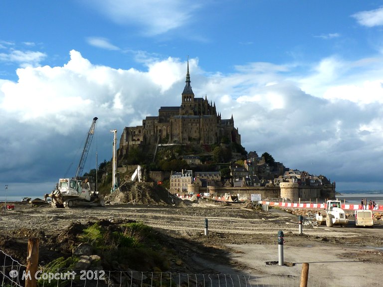
Mont St Michel submitted by theCaptain on 4th Jan 2013. They are trying to cut off the Mont again, to get the sea to surround it once more, and this involves removing the old causeway which prevented the tide clearing the silts etc, and just have a bridge going out to the Mont. This and alterations to the river should then mean the silts get washed away, and the sea once more claims the Mont at each high tide.
(View photo, vote or add a comment)
Log Text: Getting a late lunch at Plein Fougeres, it is now much too late to go to Fougeres and have a proper look round, so we decide to go to Mont St Michel for a quick look around. Shouldn't be too busy at this time of year. It has all changed since either myself or Dad was last there, and you now have to park miles away, at what is becoming a sort of holiday village resort. Many huge car parks, some hotels and restaurants etc, and a 40 min walk to the Mont, but free shuttle busses are provided. At this point I was ready to give up and drive away, but Dad still wanted to persevere, so we got the shuttle bus 10 mins out to the Mont.
Theres a hell of a lot of work going on here, both to the walls and the surroundings. Turns out they are trying to cut off the Mont again, to get the sea to surround it once more, and this involves removing the old causeway etc, and just have a sort of bridge going out to the Mont. This and alterations to the river should then mean the silts get washed away, and the sea once more claims the Mont at each high tide. I read at the new controlling dam on the river that the land has risen 4.9 metres since the 1960s. Much of these new grassy marshes is being dug up and pushed into the river, hopefully to get washed away.
The place is not too crowded, although many Japanese here, so we walk up to the abbey along the main street, no time to do the tour. Walk down around the outer walls, watching the tide coming in, and theres a group of people out walking over the sands and mud with the water coming in. Just as we leave the Mont, the sun starts to come out, making a few pictures much better.
Cup of tea, then on to Sara's, much later than we ought to be, but this time its not all my doing! Must visit here properly sometime, October Thursday mornings might be OK, but need the whole day.
Pierre Butée
Date Added: 29th Oct 2019
Site Type: Standing Stone (Menhir)
Country: France (Normandie:Manche (50))
Visited: Yes on 18th Jan 2015
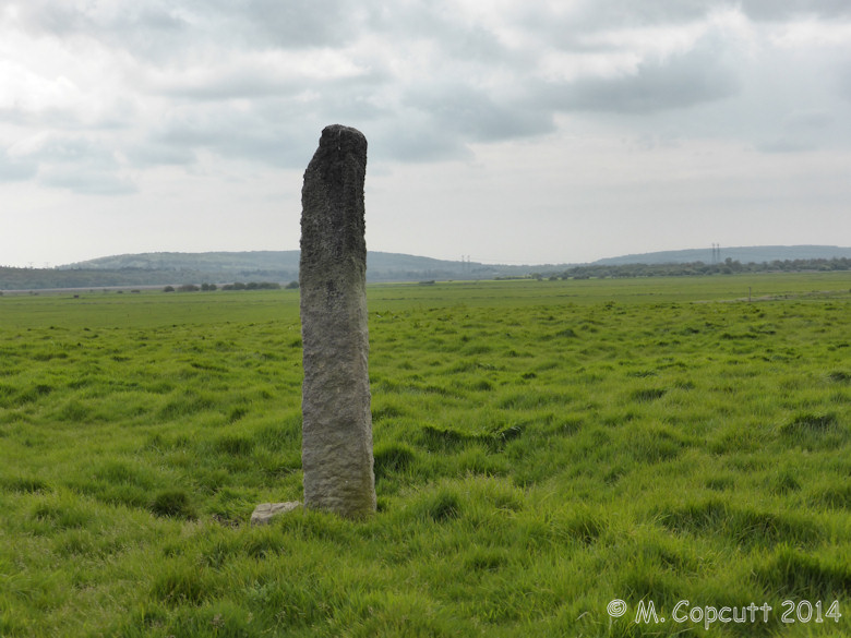
Pierre Butée submitted by theCaptain on 18th Jan 2015. Menhir on the Ile de Crosville, in the marais to the southwest of St Sauveur-Le-Vicomte the Cotentin peninsula.
(View photo, vote or add a comment)
Log Text: None
Allée Couverte d'Haye d'Ectot
Trip No.201 Entry No.20 Date Added: 25th Mar 2020
Site Type: Passage Grave
Country: France (Normandie:Manche (50))
Visited: Couldn't find on 22nd Nov 2004
Allée Couverte d'Haye d'Ectot submitted by TheCaptain on 10th Feb 2017. Carl Ashcroft sends us this picture with the following description.
I have tried to find the allee couverte at La Haye d'Ectot but could not using the location on the map on your site which is just off the D130. I looked around the area for a whole morning. Unfortunately the Mairie is closed until January. However I did bump into a man out hunting who directed me to what he believed was the correct site in a different valley further north over the other side of the valley and closer to the spr...
(View photo, vote or add a comment)
Log Text: To the south of Moitiers d'Allonne is the community of La Haye D’Ectot, which supposedly has its own Allée Couverte, which is often confused with the above. Not marked on any maps I have, I called in at the village admin centre, at this time of day now closed. Outside this was the community map and footpath guide with places of interest marked on it, but I could find no reference to any megalithic monument.
Tumuli Landes de Jobourg
Date Added: 29th Oct 2019
Site Type: Barrow Cemetery
Country: France (Normandie:Manche (50))
Visited: Yes on 18th Jan 2019

Tumuli Landes de Jobourg submitted by TheCaptain on 18th Jan 2019. Plot of the Joburg Tumuli site by R. Lemière in 1962
(View photo, vote or add a comment)
Log Text: None
Allée Couverte de Câtillon
Trip No.201 Entry No.8 Date Added: 25th Mar 2020
Site Type: Passage Grave
Country: France (Normandie:Manche (50))
Visited: Couldn't find on 22nd Nov 2004
Log Text: The remains of a second Allée Couverte is said to exist to the southeast of Rocheville, a few hundred yards from the Allée Couverte de la Petite Roche, just outside the Bois de la Grosse Roche, near the hamlet of Catillon.
It is said to be 17metres in length, southwest to northeast aspect, with a side entrance, and also with a dolmen type structure at the northeastern end. I had a good look round all the lanes and trackways in the Catillon area, but could not find anything. The one person I found to ask knew nothing of it.
Is it possible that this monument has been destroyed ?
Galerie des Forges
Trip No.201 Entry No.9 Date Added: 25th Mar 2020
Site Type: Passage Grave
Country: France (Normandie:Manche (50))
Visited: Couldn't find on 22nd Nov 2004
Log Text: The remains of a third Allée Couverte said to be found to the northeast of Rocheville, in the Bois de la Tombette, at the foot of a hill northeast of a track called La Chasse-aux-Forges, but which are difficult to find.
Well, with my luck at finding these Normandie megaliths, and with a full day planned for hunting down other sites, I drove past the suggested area in the vain hope of seeing a signpost or similar (some chance!) but in the absence of which I spent no more time looking. The Allée Couverte is reported to be 16 metres in length, with an east west aspect, width and height 1 metre, closed at the east, open to the west.
Pierres Tournantes (Néretz)
Trip No.201 Entry No.17 Date Added: 25th Mar 2020
Site Type: Standing Stones
Country: France (Normandie:Manche (50))
Visited: Couldn't find on 22nd Nov 2004
Log Text: Marked on the IGN Top 25 map as being beside a lane in a wooded area near to the Château de Néretz just to the west of the village of Teutheville-Hague, are these two menhirs, said to be 3 metres in height. However, the lane shown on the map turned out to be a gated private driveway, and so I spent no further time looking for these stones.
La Longue Pierre (St-Pierre-Eglise)
Trip No.207 Entry No.7 Date Added: 25th Mar 2020
Site Type: Standing Stone (Menhir)
Country: France (Normandie:Manche (50))
Visited: Yes on 5th Apr 2007. My rating: Condition 4 Ambience 3 Access 4
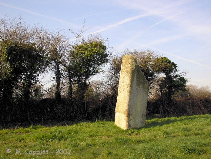
La Longue Pierre (St-Pierre-Eglise) submitted by TheCaptain on 29th Sep 2007. One of the "Three Princesses", this menhir stands 4.2 metres high, perhaps the largest menhir remaining standing in La Manche today.
(View photo, vote or add a comment)
Log Text: I was able to get right to this lovely stone this time, although in a rush as there was nowhere to park and I left the car blocking the little lane. The stone stands about 4 metres tall in a very swampy field, and I got soaking wet feet while walking up to the stone, but at least it washed clean all the mud from La Pierre Plantée. It now has a little information post at the gateway to the field, and is numbered on a marked walk around the village, so I must go and look for more information at St Pierre l'Eglise.
Mont St Michel
Trip No.203 Entry No.604 Date Added: 13th Jun 2020
Site Type: Ancient Village or Settlement
Country: France (Normandie:Manche (50))
Visited: Yes on 28th Jun 2005. My rating: Condition 5 Ambience 2 Access 4
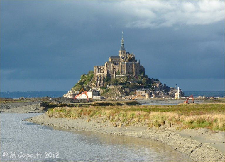
Mont St Michel submitted by theCaptain on 4th Jan 2013. They are trying to cut off the Mont again, to get the sea to surround it once more.
I read at the new controlling dam on the river that the land has risen 4.9 metres since the 1960s. Much of these new grassy marshes is being dug up and pushed into the river, hopefully to get washed away.
(View photo, vote or add a comment)
Log Text: Far too hot and busy and crowded.
St-Benoit polissoir
Trip No.210 Entry No.5 Date Added: 13th Jun 2020
Site Type: Polissoir
Country: France (Normandie:Manche (50))
Visited: Yes on 3rd Jun 2010. My rating: Condition 4 Ambience 4 Access 5
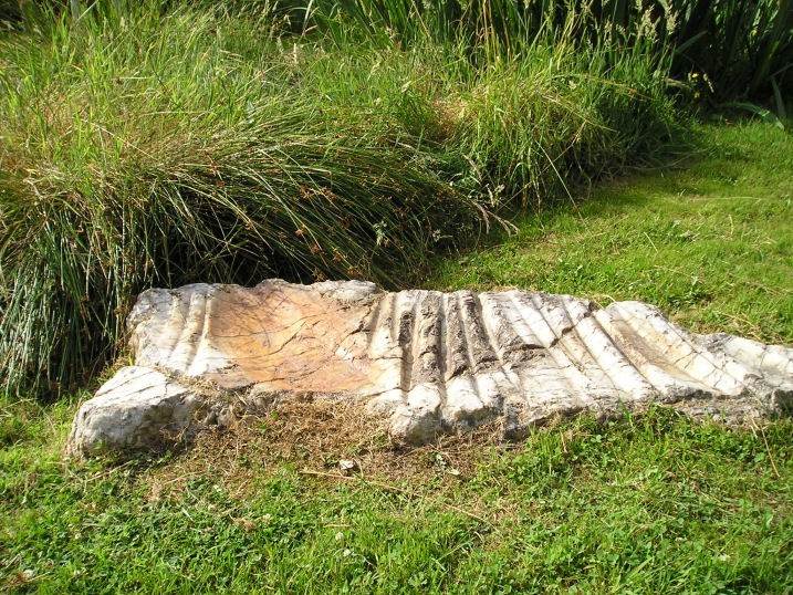
St-Benoit polissoir submitted by thecaptain on 14th Oct 2005. St Benoit polissoir, near St James.
Not a million miles from Mont St Michel, this lovely polissoir stone is nowadays nicely kept in a little garden type area beside the lane.
(View photo, vote or add a comment)
Log Text: Decide to take Dad here to see this special stone, so leave the autoroute at St James, to go have a look – the third time I will have tried to take Dad here, having missed it twice before due to roadworks and a shut bridge, and lateness on the previous occasions. Blimey, there are now big brown signs indicating it from the main road.
Set in its nice little marshy area, this is now very well looked after and presented, unlike the old description when I was first looking for it several years ago. The stone is a bit smaller than I remember it, but it is really wonderful. I just love being able to sit and stroke the very polished grooves, and let my mind wander back through the millennia. Again, Dad seemed well impressed at being able to see something like this.
Pierre Tournante (Bosgouet)
Trip No.202 Entry No.97 Date Added: 30th Mar 2020
Site Type: Burial Chamber or Dolmen
Country: France (Normandie:Eure (27))
Visited: Couldn't find on 4th May 2005
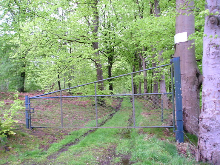
Pierre Tournante (Bosgouet) submitted by TheCaptain on 6th May 2005. Pierre Tournante, Bosgouet, Eure.
When I got there I found that the track through the forest to get to it had been gated off, with lots of barbed wire and keep out notices everywhere, so I didn’t get to visit this one.
(View photo, vote or add a comment)
Log Text: Marked on my ign map as a megalithic monument. When I got there I found that the track through the forest to get to it had been gated off with lots of barbed wire and keep out notices everywhere so I didn’t get to investigate.
Allée Couverte de Dampsmesnil
Trip No.202 Entry No.94 Date Added: 30th Mar 2020
Site Type: Passage Grave
Country: France (Normandie:Eure (27))
Visited: Yes on 4th May 2005. My rating: Condition 4 Ambience 4 Access 3

Allée Couverte de Dampsmesnil submitted by TheCaptain on 6th May 2005. A picture of the female figure stone carving at the entrance to Dampsmesnil Allée Couverte, Eure, France.
Difficult to make out in the picture, but the necklaces and breasts are clear enough.
(View photo, vote or add a comment)
Log Text: It’s easy enough to find the pathway that leads into the woods to this its signed allée couverte from several places from several miles around. However the tiny roads with cropped fields make it almost impossible to park anywhere (certainly a camper van) so it was a long walk. From the lane where the signposted track ascends into the woods its about a half kilometre walk following the main trackway up and keeping left. There is another little sign at a junction of woodland tracks where you turn left and about a further 100 metres along is this nice trench grave along with a little notice board which states that its over 4000 years old and gives descriptions of the various features. When you get there it’s a bit of a corker although falling into disrepair and in need of some affection.
The main chamber is about 10 metres long cut 2 metres deep into the hillside on an orientation of 218° looking down into the valley. There are three massive capstones each more than 3 metres long still in place and the remains of 2 more on this 2 metre wide Allée. The walls consist of large upright slabs with drystone walling between them and the whole thing ends with a massive block at the north-eastern end.
What makes this place a bit special are two features not often found elsewhere. The most obvious is the remains of the lower half of the entrance stone positioned across the chamber with it’s finely cut circular porthole entrance. The top half of the stone is missing but there is enough left to see the fine work which went into creating this entrance. It is very circular with a diameter of about 50 cm made using not just a single cut through the thick stone but a sort of double circular stepped and lipped edge.
The other special feature of this grave is found on the stone just outside the main chamber on the left hand side in front of the porthole stone and with half a capstone sat on it. On this stone has been carved the likeness of a lady (or goddess) and her two breasts can clearly be made out (although in some distant time her left one has been largely hammered away) above which are the remains of four arcs representing necklaces. I thought I could also make out some of her outline and a representation of a belt or other such item. Much of this stone is very worn and indeed I guess its only survived at all due to the presence of the half capstone and I think it said on the notice board that her face could be made out in the past. I wonder who it was.
A few other stones lie scattered about including what was probably one of the capstones which has been removed and lies partway down a steep slope several yards in front of the grave behind the notice board.
After visiting this monument I saw another one marked nearby on the map so set off to look for that. Unfortunately there was a little old narrow bridge between the two places and although my van fitted on to the bridge easily enough I had a lot of trouble getting off the other side and there was no way I was going to be able to reverse back off. After about 6 or 7 attempts to get between the protective bollards in the roadside presumably put there to protect the much wider bridge with a few scrapes down the side of my van and a broken sidelight I had discovered that the gap between the bollards was only an inch wider than the width of my van. I was obviously getting too confident about driving it around all these narrow places and will have to take more care in future.
Dolmen de l'Hôtel-Dieu
Trip No.202 Entry No.80 Date Added: 30th Mar 2020
Site Type: Burial Chamber or Dolmen
Country: France (Normandie:Eure (27))
Visited: Saw from a distance on 3rd May 2005

Dolmen de l'Hôtel-Dieu submitted by thecaptain on 19th Oct 2005. Pierre des Druides, or Hotel Dieu dolmen, near to the village of Les Ventes, seen in its field on a terribly wet morning in May.
(View photo, vote or add a comment)
Log Text: Seen a couple of hundred metres away in the middle of a field just to the northeast of the crossroads at La Trigalle It looks fairly similar to the nearby Pierre Courcoulée.
Menhir dit la Pierre de Gargantua (Neaufles)
Trip No.202 Entry No.78 Date Added: 30th Mar 2020
Site Type: Standing Stone (Menhir)
Country: France (Normandie:Eure (27))
Visited: Saw from a distance on 3rd May 2005

Menhir dit la Pierre de Gargantua (Neaufles) submitted by thecaptain on 19th Oct 2005. Pierre de Gargantua, Neauffles-Auvergny.
Seen at a distance of about 250 metres across fields from the little bridge across the Risle river.
(View photo, vote or add a comment)
Log Text: Seen at a distance of about 200 metres across fields from the little bridge across the Risle river. There wasn’t really anywhere to park and there looked no way to get to the menhir so I contented myself with a long distance shot. It must be nearly 4 metres tall in a large flat pasture beside the river.
Saint-Etienne-du-Vauvray Menhir
Trip No.202 Entry No.91 Date Added: 30th Mar 2020
Site Type: Standing Stone (Menhir)
Country: France (Normandie:Eure (27))
Visited: Yes on 4th May 2005. My rating: Condition 3 Ambience 3 Access 5

Saint-Etienne-du-Vauvray menhir submitted by thecaptain on 23rd Oct 2005. Saint-Etienne-du-Vauvray menhir, 3.5 metrws tall.
(View photo, vote or add a comment)
Log Text: About a 3.5 metre tall menhir found right beside the roadside between St Etienne and Louviers. Once the road is found the menhir is easy ! The menhir has been moved from its original position which was where the railway now is on the other side of the road.
Menhir dit Gravier de Gargantua (Chateau-Neuf)
Trip No.202 Entry No.93 Date Added: 30th Mar 2020
Site Type: Standing Stone (Menhir)
Country: France (Normandie:Eure (27))
Visited: Yes on 4th May 2005
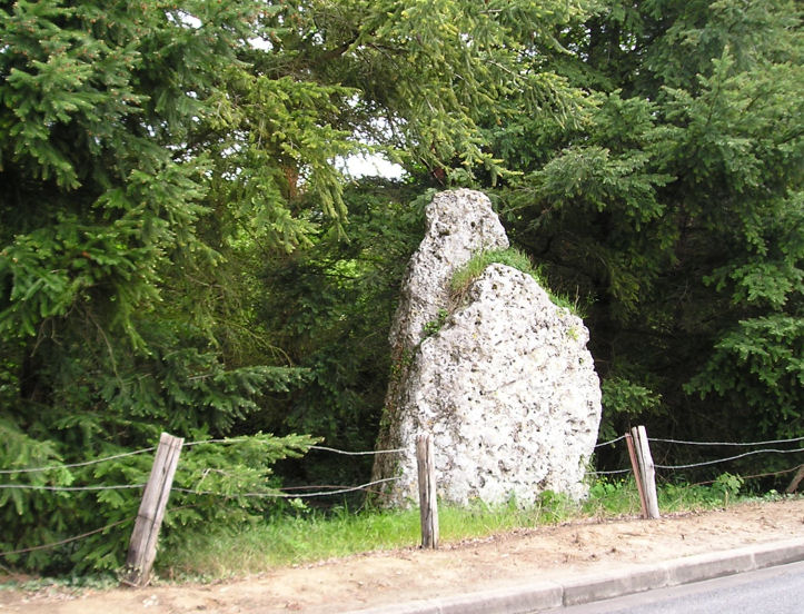
Menhir dit Gravier de Gargantua (Chateau-Neuf) submitted by thecaptain on 23rd Oct 2005. The Gravier de Gargantua is a big (3.5 metre tall, 2.5 m wide, 0.5 m thick) flinty chalky lump standing beside the road, near the village of Port-Mort in Eure
(View photo, vote or add a comment)
Log Text: A big (3.5 metre tall 2.5 m wide 0.5 m thick) flinty chalky lump stood right beside the roadside in a little fenced enclosure. It was moved here when the road was widened and a metre or so was broken off the top while doing so.
La Grosse Pierre (Verneusses)
Trip No.202 Entry No.76 Date Added: 29th Mar 2020
Site Type: Burial Chamber or Dolmen
Country: France (Normandie:Eure (27))
Visited: Yes on 2nd May 2005. My rating: Condition 4 Ambience 4 Access 5

La Grosse Pierre (Verneusses) submitted by thecaptain on 11th Nov 2005. La Grosse Pierre (Verneusses). A nice dolmen largely made from the most wonderful puddingstone slabs.
(View photo, vote or add a comment)
Log Text: A nice simple dolmen right beside the lane just to the east of the hamlet of Verneusses. The large capstone is 4 m by 3.5 m on top of 6 upright support stones. The capstone and one of the upright stones are made from a strange stony conglomerate which has lots of flints in it on one side only. Apparently this dolmen was restored badly nearly two hundred years ago.
