Contributory members are able to log private notes and comments about each site
Sites theCAptain has logged. View this log as a table or view the most recent logs from everyone
Puy de Pauliac Cromlech
Trip No.205 Entry No.27 Date Added: 19th Oct 2020
Site Type: Stone Circle
Country: France (Limousin:Corrèze (19))
Visited: Yes on 1st Sep 2005. My rating: Condition 4 Ambience 4 Access 4
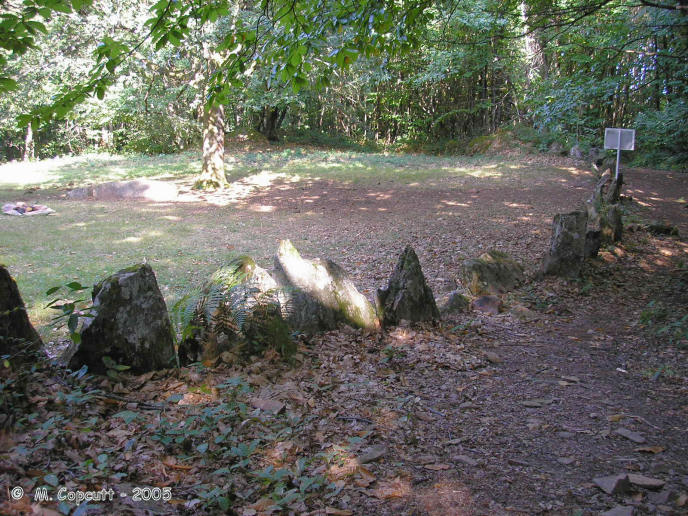
Puy de Pauliac Cromlech submitted by thecaptain on 17th Feb 2006. In a clearing on the forest covered slopes, the cromlech is made with many stones, nearly all less than a metre tall, set up almost touching each other making an enclosure which is a sort of rounded square about 40 to 50 metres across.
(View photo, vote or add a comment)
Log Text: At the top of the lovely Puy de Pauliac hill to the east of the historical village of Aubazines, is an orientation table, and fantastic views stretching for many miles in nearly all directions, with the high point of the Massif Central, the Puy de Sancy to be seen way off in the east. Near to the top of this hill is marked a cromlech, and I almost didn't find it. The cromlech can be found a bit downhill to the north of the summit, and it is signposted, although the tiny little wooden sign is easily missed, hiding in the woodland.
In a clearing in the forest covered slopes, the cromlech is made with many stones, nearly all less than a metre tall, set up almost touching each other making an enclosure which is a sort of rounded square about 40 to 50 metres across. At the southern, upslope side, is a large outcrop of natural rocks, probably 10 to 15 metres high from which the cromlech extends, joining between other significant natural rocks, to close off the area.
It is very easy to imagine a gathering of people here, with the leader stood on top of the large natural rocks giving his sermon. Within the cromlech are several nicely weathered natural granite slabs, one of which has a large break in it. These would make good seats for the best view !
Puy de Bon Temps Dolmen
Trip No.203 Entry No.91 Date Added: 6th Apr 2020
Site Type: Burial Chamber or Dolmen
Country: France (Aquitaine:Dordogne (24))
Visited: Yes on 20th May 2005. My rating: Condition 3 Ambience 4 Access 3
Puy de Bon Temps dolmen submitted by TheCaptain on 20th May 2011. The dolmen is all a bit of a jumble with many of the stones fallen and broken but the main part of the capstone is still there in position although held up by what I can only assume are roof timbers from some old building.
(View photo, vote or add a comment)
Log Text: This dolmen can be found about a kilometre walk up a forest track from the D68 between Ajat and Cubjac just north of where it passes under the new motorway and opposite a quarry entrance. It is just about signposted from the road but they are very easy to miss and when the track gets to the top of the hill you need to turn left and then left again.
The dolmen is all a bit of a jumble with many of the stones fallen and broken but the main part of the capstone about 3 by 2 metres in size is still there in position although held up by what I can only assume are roof timbers from some old building.
Just beside the dolmen is one of the cute little drystone beehive shelters (Gariotte?) that they have round here (and you can buy guide books and coffee table picture books of). Its in excellent condition with a terrific roof all covered in moss. I assume its been made using stone from the cairn for the dolmen although there is no shortage of stone round here.
Puits de Saint-Martin
Trip No.204 Entry No.266 Date Added: 11th Sep 2020
Site Type: Polissoir
Country: France (Centre:Eure-et-Loire (28))
Visited: Yes on 8th Aug 2005. My rating: Condition 4 Ambience 3 Access 4

Puits de Saint-Martin submitted by TheCaptain on 7th Aug 2013. This is a very nice polissoir stone found in the fields to the south of the village of Corancez, with several polishing stations, and a large bowl in the middle for a good water supply.
At the northwest end there are six grooves and at least a dozen flatter cuvettes.
(View photo, vote or add a comment)
Log Text: This is a very nice polissoir stone found in the fields to the south of the village of Corancez, and it is easy to find because it is signposted. It has a footpath to it across the fields, about 100 metres from the road.
It is a large stone, about 5m by 2m laying flat in the field, with at least four polishing stations, and a large bowl in the middle for a good water supply. At the southeast end of the stone there are eight deep grooves and at least six flatter basins. At the northwest end there are six grooves and at least a dozen flatter cuvettes. In the middle of the north side are another nine flattish grooves. There are many more polishing marks evident around the rest of the stone, and this was obviously a major workplace once long ago.
Puijols tumulus
Trip No.205 Entry No.87 Date Added: 28th Oct 2020
Site Type: Artificial Mound
Country: France (Languedoc:Pyrénées-Orientales 66)
Visited: Saw from a distance on 12th Sep 2005
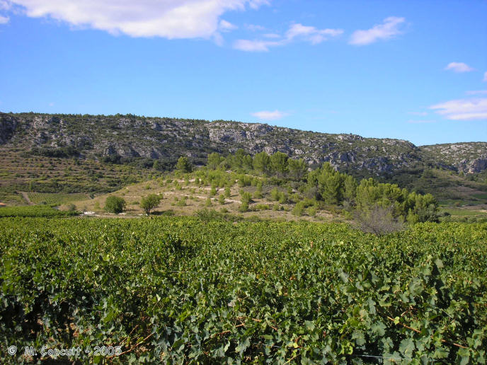
Puijols tumulus submitted by thecaptain on 4th Mar 2006. To the northwest of the village of Tautavel is a massive mound, which must be about 100 metres in diameter and 20 metres high, complete with terracing where grapes have been grown on it !
A local map clearly marks it as a tumulus.
(View photo, vote or add a comment)
Log Text: Just to the northwest of the village of Tautavel, on the opposite side of the river, is a massive tumulus, which must be about 100 metres in diameter and 20 metres high, complete with terracing and grapes growing on it !
Puerco Pueblo.
Date Added: 18th Sep 2010
Site Type: Ancient Village or Settlement
Country: United States (The Southwest)
Visited: Yes on 28th May 2009

Puerco Pueblo. submitted by thecaptain on 28th May 2009. I believe these must be the Puerco Pueblo ancient ruins.
They are definitely somewhere in Petrified Forest national park, and the old photo is in my album on the same page as the petroglyph pictures!
(View photo, vote or add a comment)
Log Text: None
Puerco Pueblo Petroglyphs
Date Added: 18th Sep 2010
Site Type: Rock Art
Country: United States (The Southwest)
Visited: Yes on 20th May 2009

Puerco Pueblo Petroglyphs submitted by thecaptain on 20th May 2009. Bird and Frog petroglyph, possibly part of Newspaper Rock, its certainly in Petrified Forest National Park, Arizona.
From a visit in November 1990.
(View photo, vote or add a comment)
Log Text: None
Puech de las Fadès
Trip No.203 Entry No.170 Date Added: 16th Apr 2020
Site Type: Hillfort
Country: France (Midi:Aveyron (12))
Visited: Saw from a distance on 26th May 2005

Puech de las Fadès submitted by thecaptain on 29th Nov 2005. Puech de las Fadès, or Hill of the Fairies in the local Occitain language.
(View photo, vote or add a comment)
Log Text: A significant hill of the region, which at the top has some significant cliff faces, making it an obvious place for a defended settlement in ancient times. Puech de las Fadès means Hill of the Fairies in the local Occitain language, and many stories and legends abound about the fairies who live on the hill, who are said to have built the nearby Buzareingues and Galitorte dolmens.
Prunarède Dolmen
Trip No.205 Entry No.157 Date Added: 11th Nov 2020
Site Type: Burial Chamber or Dolmen
Country: France (Languedoc:Hérault (34))
Visited: Yes on 18th Sep 2005. My rating: Condition 5 Ambience 4 Access 3
Prunarède Dolmen submitted by ocdolmen on 16th Apr 2006. Prunarède Dolmen summer 2003, one of my favourite dolmen. In the same area, 4 dolmens (ruinous state) and several iron age tumulus.
(View photo, vote or add a comment)
Log Text: I thought that this was going to be an easy find, but not so. Take the road north from Saint-Maurice-Navacelles towards the Cirque de Navacelles. After several kilometres you come to the ruined farmhouse of Prunarède, at a couple of sharp bends in the road. Park here, and walk along the footpath which starts behind the farm for 800 metres until the path runs out. Easy so far. The dolmen should be there, at the end of the path. Not so easy now. Where does the path end ? and what is path and what is sheeptrack ?
I eventually found the dolmen, I had walked way past expecting it to be obvious, but it wasnt. It is well hidden in the bushes, to the right of where I had walked. Its a smashing dolmen, still with a cairn around it encircled with larger slabs of stone. The chamber is 3.5 metres long, between 1.5 and 2 metres wide, and formed with two side slabs leaning inwards onto a front and back stone. These are all fitted together so well, that even after 5000 years, there's not much more than an inch gap anywhere. There is no way into the chamber except to get a look through a gap under the capstone from one side. The capstone sits nicely on top of three of the four stones. I cannot tell where the entranceway would have been, or which is front and back.
Unfortunately, there are remnants from a fence which had been built around it in the past, in the form of a square of stones around the chamber on top of the cairn, and the remains of iron railings. The views from here would be tremendous if the scrub was cut back, but are however very limited.
Princes Risborough Puddingstone
Date Added: 18th Sep 2010
Site Type: Natural Stone / Erratic / Other Natural Feature
Country: England (Buckinghamshire)
Visited: Yes on 16th Oct 2006
Princes Risborough Puddingstone submitted by thecaptain on 16th Oct 2006. The puddingstone is now lovingly presented with floral surrounds and an informative little sign.
(View photo, vote or add a comment)
Log Text: None
Primelin stèle
Trip No.203 Entry No.475 Date Added: 26th May 2020
Site Type: Standing Stone (Menhir)
Country: France (Bretagne:Finistère (29))
Visited: Yes on 18th Jun 2005. My rating: Condition 4 Ambience 3 Access 5
Primelin stèle submitted by theCaptain on 19th Jun 2012. This is a nice 2.5 metre tall granite stèle stood just outside the church at Primelin.
(View photo, vote or add a comment)
Log Text: This is a nice 2.5 metre tall granite stèle stood just outside the church at Primélin. It has been broken at some point, and the top has been cemented back on.
Priddy Nine Barrows
Date Added: 29th Oct 2019
Site Type: Barrow Cemetery
Country: England (Somerset)
Visited: Yes on 2nd Dec 2017
Priddy Nine Barrows submitted by TheCaptain on 2nd Dec 2017. Priddy Nine Barrows seen here from the south, near Eastwater Cavern
(View photo, vote or add a comment)
Log Text: None
Priddy Circles Unfinished N
Date Added: 29th Oct 2019
Site Type: Henge
Country: England (Somerset)
Visited: Yes on 4th Jul 2011
Priddy Circles Unfinished N submitted by TheCaptain on 4th Jul 2011. The eastern arc of the fourth Priddy Circle, seen over the top of the hedge from the roadside, June 2011.
The fence helps to give a good idea off the size of the remaining bank and external ditch.
(View photo, vote or add a comment)
Log Text: None
Priddy Circles S
Date Added: 29th Oct 2019
Site Type: Henge
Country: England (Somerset)
Visited: Yes on 19th Jun 2011
Priddy Circles S submitted by TheCaptain on 19th Jun 2011. The field where the southern of the Priddy Circles should be.
Here viewed over the hedge from the B3135 near Harptree Lodge, Sunday June 19th, and there is no immediate sign of the henge at all.
(View photo, vote or add a comment)
Log Text: None
Priddy Circles N
Date Added: 29th Oct 2019
Site Type: Henge
Country: England (Somerset)
Visited: Yes on 25th Oct 2011
Priddy Circles N submitted by theCaptain on 25th Oct 2011. Priddy Northern circle, June 2011.
Seen here looking west from the B3134, it is quite difficult to make the circle out, but it is mostly to be seen. Look over the three foreground fences, then you see lumps and bumps of the eastern arc. The next wall and fence cut the circle pretty much in half, and the western arc is quite clear beyond that as it is where all the dark bushes are growing.
(View photo, vote or add a comment)
Log Text: None
Priddy Circles C
Date Added: 29th Oct 2019
Site Type: Henge
Country: England (Somerset)
Visited: Yes on 22nd Oct 2011
Priddy Circles C submitted by theCaptain on 22nd Oct 2011. Priddy Central circle, June 2011.
Looking north at the eastern edge where the wall cuts the circle
(View photo, vote or add a comment)
Log Text: None
Presqu'île de la Torche
Trip No.203 Entry No.470 Date Added: 25th May 2020
Site Type: Passage Grave
Country: France (Bretagne:Finistère (29))
Visited: Yes on 17th Jun 2005. My rating: Condition 3 Ambience 5 Access 4
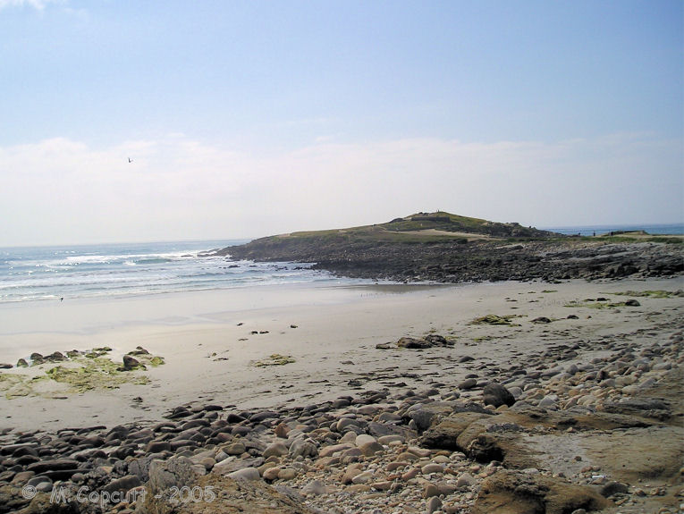
Presqu'île de la Torche submitted by thecaptain on 18th May 2009. The remains of what would no doubt have once been a magnificent monument, is positioned on top of this little headland, almost an island, sticking dramatically out into the wild Atlantic Ocean, and surrounded by magnificent surf beaches.
(View photo, vote or add a comment)
Log Text: The remains of what would no doubt have once been a magnificent monument, positioned on top of this little, almost an island, headland, sticking dramatically out into the wild Atlantic Ocean, and surrounded by magnificent surf beaches.
The central passage is still 16 metres in length, running up and over the top of the mound, curving as it goes, and opening to the east. At the west end there is an upright end stone. On the top of the mound, a few metres in from the end stone, are two side chambers each about 3 metres by 1.5 metres, one of which still has capstones in place, although it is all much ruined. Considering the concrete all around, for wartime bunkers and lookout posts, and for tourist paths and observation tables, it is surprising anything has survived here - that so much has is incredible. There is possible some remnants of a second chamber up here too.
The most wonderful thing about this place is the situation. The surf is crashing in all around the end of the point, and the waves rolling by on both sides of the headland in this surfers paradise. Its a fantastic place to sit and watch the waves go by. I love it. It makes me want to go surfing again. I bet I could still do it. They are even playing Camel's "Snow Goose" in the bar at the car park. Now if that isn't meaningful......
Predannack Cross
Date Added: 28th Jun 2023
Site Type: Ancient Cross
Country: England (Cornwall)
Visited: Yes on 12th Jun 2023. My rating: Condition 4 Ambience 4 Access 4
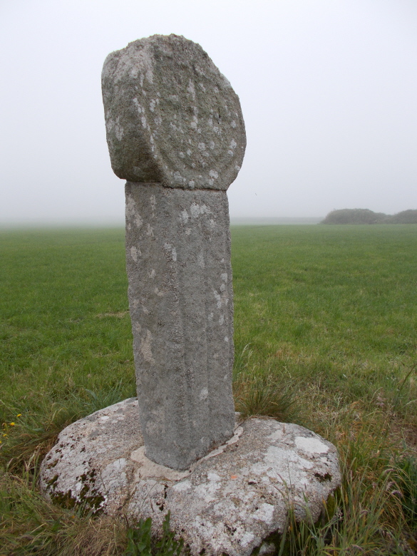
Predannack Cross submitted by AngieLake on 29th Jun 2016. The rear of Predannack Cross and a misty field.
(View photo, vote or add a comment)
Log Text: A walk from Mullion Cove to Predannack and back along the cliffs. This lovely cross is in a corner of a field.
Prédaire Dolmen
Trip No.203 Entry No.30 Date Added: 1st Apr 2020
Site Type: Chambered Cairn
Country: France (Pays de la Loire:Loire-Atlantique)
Visited: Yes on 14th May 2005. My rating: Condition 2 Ambience 5 Access 4
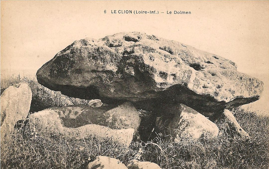
Prédaire Dolmen submitted by TheCaptain on 12th Oct 2018. From ichel Baconnais
Le dolmen du Pré d'air. Jusque vers 1970, ce lieu était recouvert d'épineux. Pour des raisons touristiques, la végétation a été enlevée, et le sol s'est érodé très vite. Ainsi, en 2003, la pierre du sommet présentant un danger, a été enlevée à la hâte sans repérage préalable. Aujourd'hui, ce site ruiné par la main de l'homme, n'est plus qu'un tas de pierraille. L'endroit était autrefois connu sous le nom "Perder" ou "Peurdaire", ce qui signifiait les ...
(View photo, vote or add a comment)
Log Text: This much ruined transepted burial mound sits on a clifftop overlooking the sea to the south of the seaside harbour town of Pornic. I had chosen to spend the night at the campsite la Boutinardière and went for an evening stroll for 20 minutes or so northwest along the Sentier des Douarniers coastal footpath past some strange jetties with boat lifts jutting into the sea at the foot of the cliffs before reaching the dolmen as the sun was going down.
The main entrance corridor is about 7 metres long and is orientated on a bearing of 142° which looks directly towards a nearby headland. There are two large transept chambers each about 2.8 m by 1.7 metres in size but only a single smaller end chamber perhaps about 2.2 by 2 metres in size. Strangely situated side on to the slope maybe the shape of the ground has changed significantly over the millennia.
Just up the slop from the remains is a very large stone which is possibly the remains of a large capstone but perhaps just a boulder placed here to prevent vehicles driving down over the remains from the fields above. It was apparently excavated in 1878 with finds from the Neolithic which are now in the Musée Dobrée in Nantes.
Pré-de-Roi Menhir
Trip No.205 Entry No.135 Date Added: 10th Nov 2020
Site Type: Standing Stone (Menhir)
Country: France (Midi:Tarn (81))
Visited: Yes on 16th Sep 2005. My rating: Condition 4 Ambience 3 Access 5
Pré-de-Roi menhir submitted by theCaptain on 1st Nov 2010. The Pré-de-Roi menhir is 2.5 metres tall and looks for all the world like it should be carved into a statue menhir.
Perhaps it once was, and all the features have been eroded away by several thousand years of being in the open.
(View photo, vote or add a comment)
Log Text: The Pré-de-Roi menhir is found right beside the road to the west of Murat, just beyond the road to the village of Candoubre. It is 2.5 metres tall, nearly 2 metres wide, and looks for all the world like it should be carved into a statue menhir. Perhaps it once was, and all the features have been eroded away by several thousand years of being in the open. A nice menhir anyway.
Prat Meur menhir
Trip No.203 Entry No.530 Date Added: 29th May 2020
Site Type: Standing Stone (Menhir)
Country: France (Bretagne:Finistère (29))
Visited: Yes on 22nd Jun 2005. My rating: Condition 3 Ambience 3 Access 4
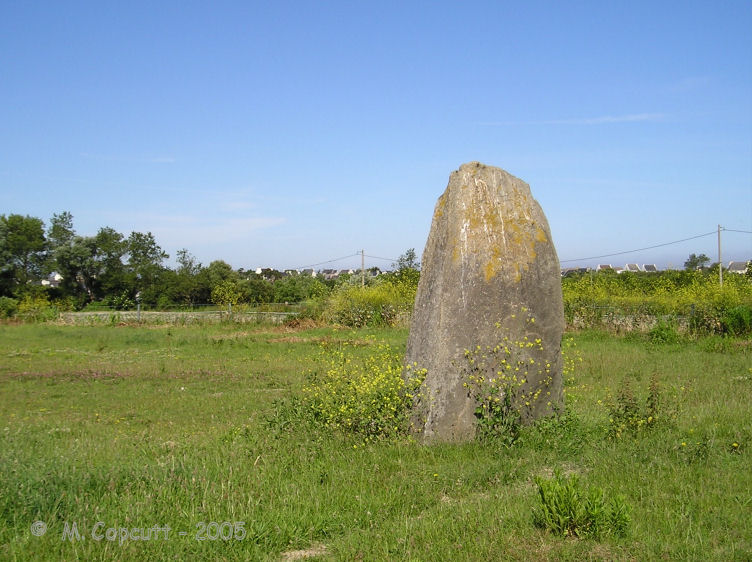
Prat Meur menhir submitted by thecaptain on 24th Jan 2009. This is a pleasant enough menhir, stood in a field beside a trackway at the end of the lane from the port to Prat Meur hamlet.
(View photo, vote or add a comment)
Log Text: This is a pleasant enough menhir, probably 2.8 metres tall and nearly as wide, but less than a metre thick. It is stood in a field beside a trackway at the end of the lane from the port to Prat Meur hamlet. It is nicely weathered at the top.
Somebodies air force is out and about, looks like F.16s so it isn't the French. Probably on holiday at Landivisiau. Suddenly there's a commotion, and a dog barking. A large rabbit or hare flashes past me about 5 metres away, with a dog hotly in chase about 15 metres behind. The rabbit is across a field of artichokes and into a hedge before the dog, and it all goes quiet, before a man is out and whistling to the dog. An interesting little episode.
