Contributory members are able to log private notes and comments about each site
Sites theCAptain has logged. View this log as a table or view the most recent logs from everyone
An-Eured-Ven
Trip No.203 Entry No.544 Date Added: 2nd Jun 2020
Site Type: Stone Row / Alignment
Country: France (Bretagne:Finistère (29))
Visited: Yes on 23rd Jun 2005. My rating: Condition 3 Ambience 4 Access 4

An-Eured-Ven submitted by thecaptain on 13th May 2008. a couple of hundred metre long, slightly curved line of white quartz blocks running along the ridgetop just to the south of the lake.
(View photo, vote or add a comment)
Log Text: On the high moorland to the southwest of the St Michel reservoir, in the bowl below the Montagnes d'Arrée to the southeast of Mont St Michel, can be found some rows of white quartz stones, the name of which, An-Eured-Ven, translates to something approximating the wedding stones dance.
I found a couple of hundred metre long, slightly curved line of white quartz blocks running along the ridgetop just to the south of the lake, the alignment of which varies from 078° to 085° as you go from west to east. Further thoughts on what I found, and I think its perhaps more like two straight rows which converge on a point, or a kinked row, rather than curved. At the kink there is a collection of larger stones which may at one point have been significant. At the eastern end the stones are bigger, and the last stone I found is positioned across the end of the row rather like a Dartmoor blocking stone. The row does not align on St Michel Hill, nor at this eastern end go along the top of the ridge as it runs away at 279°. The western end of the row just seems to fade away into the undergrowth.
Further looking around and I found another line of stones about 100 metres to the north, and which looks to be on an approximately parallel course to the first row. There are lots of other blocks of stone to be seen in amongst the heather, I wonder if a full survey has ever been done here ?
From on top of St Michel Hill, using binoculars, the two rows of stones can clearly be seen, but they form a sort of V shape, with the point towards the east. There is a group of schoolchildren out amongst the rows, with musicians and storytellers. What a great lesson they must be having.
Anasazi Indian State Park
Date Added: 29th Oct 2019
Site Type: Ancient Village or Settlement
Country: United States (The Southwest)
Visited: Yes on 5th Dec 2010

Anasazi Indian State Park submitted by TheCaptain on 5th Dec 2010. Some of the structures at Boulder Anasazi village.
Picture from a 1990 trip, and now faded and deteriorated.
(View photo, vote or add a comment)
Log Text: None
Andillé Dolmen
Trip No.204 Entry No.152 Date Added: 17th Aug 2020
Site Type: Burial Chamber or Dolmen
Country: France (Poitou:Vienne (86))
Visited: Saw from a distance on 20th Jul 2005. My rating: Access 4

Andillé dolmen submitted by TheCaptain on 3rd Dec 2007. About 50 metres to the south of the road to the east of Andillé (Route de Dolmen), in a field of sweetcorn, I could just see the top of this dolmen.
There was no obvious way of getting to it to have a proper look.
(View photo, vote or add a comment)
Log Text: About 50 metres to the south of the road (Route de Dolmen), in a field of sweetcorn, I could just see the top of this dolmen. There was no obvious way of getting to it to have a proper look, but it looks to be the remains of a little simple dolmen.
Andover Museum of the Iron Age
Date Added: 28th Oct 2019
Site Type: Museum
Country: England (Hampshire)
Visited: Yes on 23rd Aug 2019
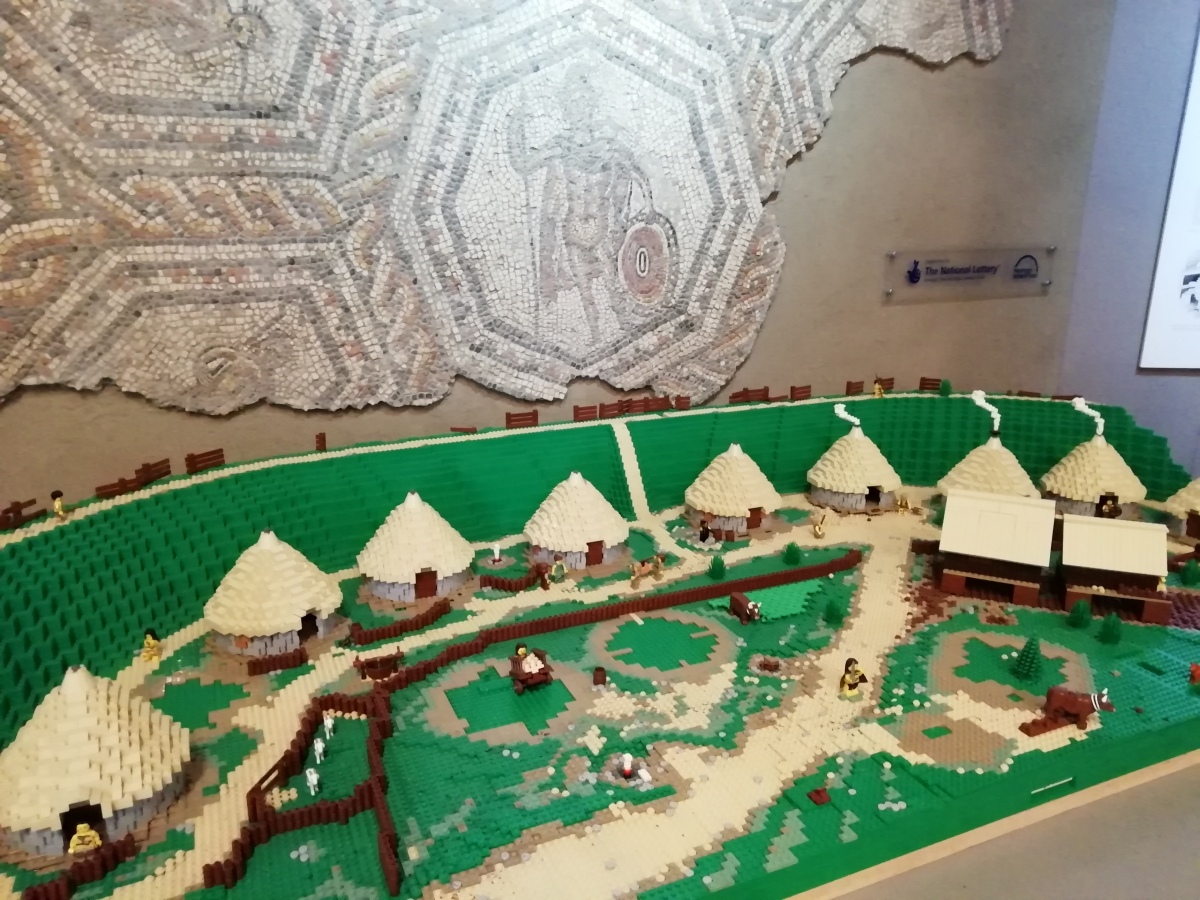
Andover Museum of the Iron Age submitted by TheCaptain on 25th Aug 2019. Lego model of an Iron Age hillfort in the entrance to the Andover Museum of the Iron Age.
Behind is part of the Fullerton Mosaic, which was found in the main room of a Romano-British villa in the nearby village of Fullerton. The centre piece to the mosaic is the god Mars in his role as protector of agriculture.
(View photo, vote or add a comment)
Log Text: I particularly liked the Lego model of an Iron Age hillfort situated in front of the Roman Fullerton Mosaic, which was found in the main room of a Romano-British villa in the nearby village of Fullerton. The centre piece to the mosaic is the god Mars in his role as protector of agriculture.
Aneran stone
Trip No.205 Entry No.63 Date Added: 25th Oct 2020
Site Type: Standing Stone (Menhir)
Country: France (Midi:Hautes-Pyrénées (65))
Visited: Yes on 8th Sep 2005. My rating: Condition 3 Ambience 3 Access 4

Aneran stone submitted by thecaptain on 22nd Jan 2006. The prehistoric stone here is the dark grey cylindrical block, stood beside the buttress at the rear corner of the church.
It's about 1.2 metres tall, and approximately circular in section with about 30 cm diameter. It reminds me a bit of some of the iron age steles in Brittany.
(View photo, vote or add a comment)
Log Text: Deep into the Louron valley, on the western side of the Col de Peyresourde in the high Pyrenees, is the tiny village of Aneran. In the tiny churchyard beside this small ancient church in this little Pyrenean village are several odds and ends of old stone, some carved into shapes and and with patterns on them.
I assume the prehistoric stone here is the dark grey cylindrical block, stood beside the wall at the corner of the church. Its about 1.2 metres tall, and approximately circular in section with about 30 cm diameter. It reminds me a bit of some of the iron age steles in Brittany. The church also has some fascinating carved stones built into its walls. An interesting little place.
Anta Da Comenda Grande
Date Added: 3rd Nov 2019
Site Type: Burial Chamber or Dolmen
Country: Portugal (Évora)
Visited: Yes on 13th Oct 2019. My rating: Condition 3 Ambience 4 Access 4

Anta Da Comenda Grande submitted by Bak_teria on 18th Nov 2014. The Anta is visible from the road side. Unfortunately there is no direct access to it, there is a fence blocking the passage.
(View photo, vote or add a comment)
Log Text: Leave the Anta Grande da Comenda da Igreja and drive towards São Geraldo, then east towards Sabugueiro for about half a kilometre until the road goes over a small hill through a little cutting then down onto the open plains. The dolmen is just off to the north side of the road at the position of the little cutting, and can be seen from the road.
I parked and walked back to get a better look, the cork oak wodded pasture within which the dolmen stands had a large herd of magnificent horned cattle, which after inquisitively looking at me, decided to leave the area. I was able to get decent views of the dolmen from a few vantage points, but be careful, as at one point I slipped and fell down onto the road as the ground beneath me gave way and avalanched me down onto the road, luckily with nothing passing at the time.
Anta de Folgos I
Date Added: 26th Oct 2019
Site Type: Burial Chamber or Dolmen
Country: Portugal (Évora)
Visited: Saw from a distance on 13th Oct 2019. My rating: Access 4
Log Text: Saw this from the car while driving south east. Nowhere obvious to park to go back and have a look, so didn't.
Anta de Pavia
Date Added: 25th Oct 2019
Site Type: Burial Chamber or Dolmen
Country: Portugal (Évora)
Visited: Yes on 12th Oct 2019. My rating: Condition 4 Ambience 3 Access 5

Anta de Pavia submitted by Bak_teria on 25th Sep 2014. A view from the left side.
(View photo, vote or add a comment)
Log Text: Chapel built into a huge Anta (dolmen) now in a square in the sleepy village of Pavia. The chapel is locked shut, but has a gate of iron railings allowing us to view inside. The nearby Café du Dolmen is also closed, and a few old chaps sit nattering in the shade of a small shelter on the square. Difficult to photograph in the bright sun, as it is mostly in shadow.
Anta do Barrocal 2
Date Added: 28th Oct 2019
Site Type: Burial Chamber or Dolmen
Country: Portugal (Évora)
Visited: Saw from a distance on 13th Oct 2019. My rating: Condition 3 Ambience 3 Access 3

Anta do Barrocal 2 submitted by Bak_teria on 9th Mar 2015. A view from near by Barrocal 2 in 2015.
(View photo, vote or add a comment)
Log Text: From the dolmen 1, I see a gate with signpost into the field, so use that to get out, and start to look for the dolmen number 2, which is on the other sde of the trackway. I see it up on the hillside a hundred yards or so away, and with no obvious way in, and cattle in the field.
Compared to the number 1, its a bit of a wreck anyway, so I make do with a couple of pictures from the trackway. At this point, while going back to the car, I see somebody on a quadbike haring up the lane towards me, so I nod and wave at him as he approaches. He slows down and looks like he's heading into the nearby field, but just looks at me, turns round and heads back from whence he came. I guess he had seen me from the farm and was just checking me out, but as I was obviously leaving anyway said nothing.
Anta Grande da Comenda da Igreja
Date Added: 3rd Nov 2019
Site Type: Burial Chamber or Dolmen
Country: Portugal (Évora)
Visited: Yes on 13th Oct 2019. My rating: Condition 4 Ambience 5 Access 4
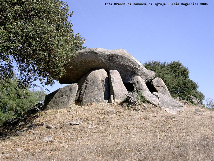
Anta Grande da Comenda da Igreja submitted by Magalhaes on 21st Apr 2006. Anta Grande da Comenda da Igreja
(View photo, vote or add a comment)
Log Text: I drove north through Montemor-o-Novo, and using a combination of the Satnav and my Google map, found the right place to visit the Anta Grande da Comenda da Igreja. However, it is not simple to find and takes a read of my notes and open the portal page to get full directions.
I park at the relevant position, at the place where there is a metal gate at the west side of the road just north of a river crossing, but there are no signs and nothing obvious. However, having now experienced a few of these, I am able to open the gate and walk through and along the trackway, until I find an even more complex gate arrangement, which I can also pass through following my Google satellite position. There is still nothing obvious to see, but further along descending towards the river bed, and a small wooded area becomes obvious after about 2/3 kilometre, to which I procede, and find a sign for the historical monument. Through another little gate into this wooded area which is fenced off from the main pastures and all of a sudden the monument becomes obvious.
What I find is basically a large round mound perhaps 40 metres diameter, with what appear to be remains of a couple of encircling stone kerbs. At the top of the mound can be seen what appears to be a large dolmen with a broken capstone. Walking around the mound, and there appears what is another smaller dolmen chamber towards the edge, but this turns out to be an entrance corridor to the main chamber.
The construction is huge, the entrance corridor would have been big enough to allow easy entrance and must be at least 10 metres in length stretching to the main chamber. However it is all full of dirt, rubble and nasty looking beasties, so I leave it all well alone. Looking at the main chamber from the top of the mound, it must be nearly 5m long by 4m wide, and although the floor has a lot of rubble and infill on it, must be about 6 metres in height. So this is what Zambujeiro would have been like before it was all dug out and became broken, but not quite as big. It is fabulous.
There is lots of wildlife here, all sorts of birds, butterflies and ants as big as mice! Well worth a visit.
Anta Grande do Zambujeiro
Date Added: 4th Nov 2019
Site Type: Burial Chamber or Dolmen
Country: Portugal (Évora)
Visited: Yes on 13th Oct 2019. My rating: Condition 3 Ambience 2 Access 4
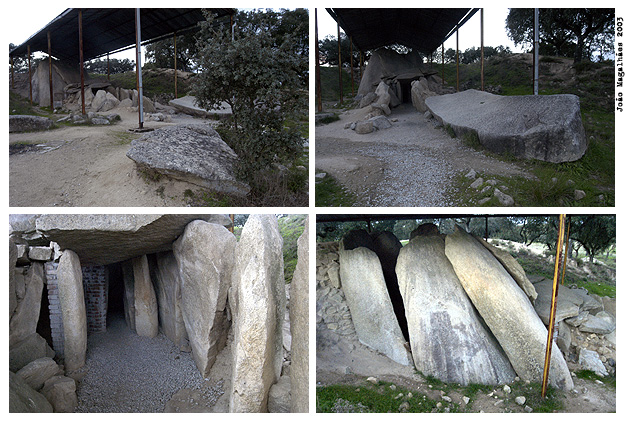
Anta Grande do Zambujeiro submitted by Magalhaes on 14th Apr 2006.
(View photo, vote or add a comment)
Log Text: With claims to being the largest burial chamber in the Iberian Peninsula, and hence one of the biggest in the world, the Anta Grande do Zambujeiro is relatively easy to find, as it is on all the megalithic circuits and leaflets, and signposted from all around. However, it is again about a kilometer along a dirt track, this one not very smooth and with some huge potholes in, so be careful. There is a nice shady place to park, with several cars in it, from where it is a couple of hundred metres walk across a footbridge and field to the fenced in site.
It is huge, but all a bit of a mess, with a big iron shed built over most of it. The entrance corridor is all falling down, and any sort of entrance to the main chamber is well blocked off. It was all obviously once buried under an enormous mound, most of which remains, but the main structure has been dug out, which is what is causing it to collapse. The main chamber, still partially enclosed, is massive and must be almost 8 metres tall, made from huge slabs. For somebody more nimble than me, it would be possible to get in through a gap in some of the side slabs, but good luck getting out again as it's 2 metres down to the floor! The capstone has been removed and lies on the ground on the slope of the mound behind the chamber. There are several other large slabs, with cupmarks and other engravings laying down outside the entrance.
Despite its massive size, and obvious importance, for me it all lacked something, perhaps because of the shed and fencing. I hope that something can be done to stabilise and repair it, and make it a much more pleasant place to visit, as obviously a lot of people do come here.
Anta Herdade do Barrocal 1
Date Added: 29th Oct 2019
Site Type: Burial Chamber or Dolmen
Country: Portugal (Évora)
Visited: Yes on 13th Oct 2019. My rating: Condition 4 Ambience 4 Access 4

Anta Herdade do Barrocal 1 submitted by KenWilliams on 26th Feb 2007. The larger Barrorcal Anta, the second, smaller one is behind the trees to the right of that tower in the background.
(View photo, vote or add a comment)
Log Text: From Evora it was time for my day hunting stones. Thankfully I had done much previous research, otherwise I would have found it extremely difficult. I struggled to get out of the walled city of Evora, round all the one way systems etc, but eventually after finding a place to stop, where I figured out how to use the satnav, and there was no looking back!
The next problem was how to locate the sites, as nothing is on any maps, and very little is signposted. However, with use of my previously prepared Google map of sites, and better phone coverage out here than most places at home, I was able to locate the road to these dolmens, where I realised that many of the roads are actually dirt and gravel tracks, and many seem to start from the main roads through gated entrances.
About threequarters of a km along the dirt track to Barrocal, and I see the old windmill and a place I can park, and then I see the dolmen just in the field to the right. There is a path to it, and it is well sited on the top of a hillock, a nicely complete dolmen with remains of its entrance passageway. It is not very picturesque today, grey skies threatening to rain, and the ground covered in scrub.
Anta-Capela de Nossa Senhora do Livramento
Date Added: 29th Oct 2019
Site Type: Burial Chamber or Dolmen
Country: Portugal (Évora)
Visited: Yes on 13th Oct 2019. My rating: Condition 4 Ambience 3 Access 5

Anta-Capela de Nossa Senhora do Livramento submitted by Magalhaes on 15th Apr 2006. "Anta" of N S do Livramento
(View photo, vote or add a comment)
Log Text: Several miles along a very narrow and twisty road, and I eventually arrived at the Anta-Capela de Nossa Senhora do Livramento, or Anta-Capela de São Brissos, which was one I really wanted to visit, the white painted dolmen now built into a chapel, complete with blue stripe around the bottom to keep the devil at bay.
Despite the satnav trying to take me somewhere else, I found it easy enough, and it has a small car park which had another three cars in it. Before I had even got out of my car, a bloke (French I think) from one of the other cars was over asking if I had the key to the chapel, and was most insistent that I should have it, not taking the fact that I am just an English tourist as an answer!
So as I gathered, the chapel was locked up, so could not get to see inside. It's a wierd and beautiful little place, and unlike that at Pavia, this has an extension built onto the back of the dolmen. There is one large stone laying beside the chapel, and traces of its entrance passageway.
Aqueduc d’Ansignan
Trip No.205 Entry No.95 Date Added: 7th Nov 2020
Site Type: Ancient Mine, Quarry or other Industry
Country: France (Languedoc:Pyrénées-Orientales 66)
Visited: Yes on 13th Sep 2005. My rating: Condition 4 Ambience 4 Access 4
Aqueduc d’Ansignan submitted by TheCaptain on 6th Nov 2020. Ancient bridge and aqueduct spanning the river below the village of Ansignan, the basis of which is a Roman bridge, probably from the 3rd century.
(View photo, vote or add a comment)
Log Text: Ancient bridge and aqueduct spanning the river at the village of Ansignan, still used to irrigate crops on the opposite bank. It is built on the basis of a Roman bridge, probably from the 3rd century.
To cross the bridge, with the aqueduct built on top, you walk within an enclosed passage with a few holes for light, and it seems rather like walking along a passage within the walls of a castle.
Arkeologi Museoa - Bizkaia
Date Added: 29th Oct 2019
Site Type: Museum
Country: Spain (Pais Vasco)
Visited: Yes on 4th Jul 2013
Arkeologi Museoa - Bizkaia submitted by theCaptain on 4th Jul 2013. Just off Plaza de Miguel de Unamuno, up the obvious staircase at Calzadas de Mallona 2, the museum has two floors for exhibits in a very modern building.
(View photo, vote or add a comment)
Log Text: None
Arlait Dolmens
Trip No.204 Entry No.158 Date Added: 17th Aug 2020
Site Type: Burial Chamber or Dolmen
Country: France (Poitou:Vienne (86))
Visited: Yes on 21st Jul 2005. My rating: Condition 3 Ambience 4 Access 4

Arlait dolmens submitted by TheCaptain on 6th Dec 2007. The dolmen is then about 80 metres to the north down a wide open trackway, in a little round woodland area.
(View photo, vote or add a comment)
Log Text: Being more careful this time, and not in so much of a rush, I was able to find this dolmen. Follow the signs to the north of the village of Chateau Larcher for about a kilometre, and just before the road gets to the top of the hill, stop. There is a little dirt track which crosses the road, and if you look carefully, has a little painted sign to dolmen, to the west (left) of the road. Follow this track for about 800 metres, alongside a large wire fence most of the way, and the dolmen is then about 80 metres to the north (right) down a wide open trackway. The dolmen is a fairly large one, with a rectangular chamber about 4 metres by 3.5 metres, with an entranceway facing to the southeast.
The rock is very holey limestone, and much of it has cracked and crumbled, and the capstone has all fallen in. In fact it looks to have broken very recently, as a couple of the breaks are very fresh. The dolmen is still within the remains of a fair sized mound of loose rock, probably 25 to 30 metres in diameter, covered in the inevitable oak woodland. There are several other slabs of rock laying about, and I wondered if there was a second chamber within the mound. While I was sat here, there were a couple of deer not far away, looking at me.
Armenteule Menhir
Trip No.205 Entry No.64 Date Added: 25th Oct 2020
Site Type: Standing Stone (Menhir)
Country: France (Midi:Hautes-Pyrénées (65))
Visited: Yes on 8th Sep 2005. My rating: Condition 4 Ambience 4 Access 4
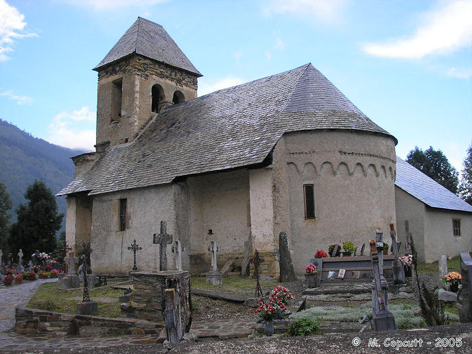
Armenteule menhir submitted by thecaptain on 7th Feb 2006. Deep in the Louron valley, on the western side of the Col de Peyresourde in the high Pyrenees, is the tiny village of Armenteule.
In this sleepy little Pyrenean village there is an old church. Inside the churchyard, just beside the back of the church, is a standing stone....
(View photo, vote or add a comment)
Log Text: Deep in the Louron valley, on the western side of the Col de Peyresourde in the high Pyrenees, is the tiny village of Armenteule. In this sleepy little Pyrenean village there is an old church. Inside the churchyard, just beside the back of the church, is a standing stone. Whether the church was built beside the menhir, or the stone was brought here later I do not know.
The stone is a piece of slatey schist, stands some 1.3 metres tall, and is approximately 40 cm wide by 20 cm thick at the base, tapering slightly to the top. The whole place has a nice feel about it, as if its as old as the hills, and that man has been living and farming here for eternity. It is slightly strange that this stone (and that at nearby Aneran) is made of a dark grey / black slatey stone, when the majority of stone round here is pale granite.
Arques Dolmen
Trip No.205 Entry No.165 Date Added: 24th Nov 2020
Site Type: Burial Chamber or Dolmen
Country: France (Languedoc:Gard (30))
Visited: Yes on 19th Sep 2005. My rating: Condition 3 Ambience 3 Access 4
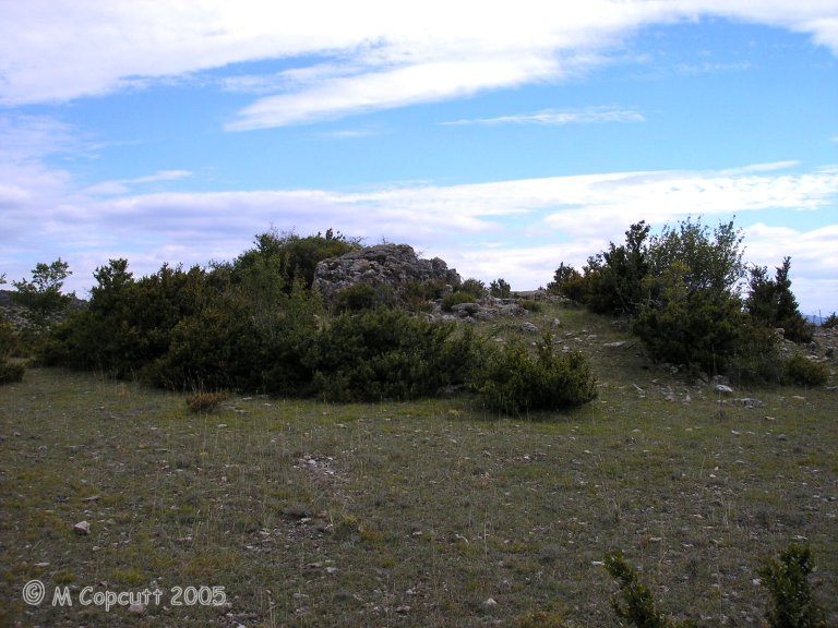
Arques Dolmen submitted by thecaptain on 9th Dec 2009. The remains of this fairly large dolmen are just off the road, and still mostly within a fairly large tumulus.
(View photo, vote or add a comment)
Log Text: This dolmen can be found just to the left of the road west from Planas towards Le Quintanel, turning left just before you reach Le Landre and continuing for about a kilometre until you pass the brow of a hill.
The remains of this fairly large dolmen are just off the road, and still mostly within a fairly large tumulus. The back stone and two side slabs are in position, but the capstone is dislodged to one side. The chamber is 3 metres long by 2.5 metres wide, and would probably have been large enough to stand in. There is the remains of a 7 metre long by 0.7 metre wide entry passage through the tumulus, which opens, as they all seem to do round here, towards the southwest, at 237°.
Ashen Hill Barrows
Date Added: 18th Sep 2010
Site Type: Barrow Cemetery
Country: England (Somerset)
Visited: Yes on 25th Aug 2004
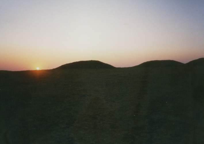
Ashen Hill Barrows submitted by thecaptain on 25th Aug 2004.
Its a photo of mine from several years ago, and I think its probably Ashen Hill, but can't be sure - it could be Priddy Nine Barrows.
(View photo, vote or add a comment)
Log Text: None
Ashley Cross tumuli
Date Added: 8th Feb 2022
Site Type: Round Barrow(s)
Country: England (Hampshire)
Visited: Yes on 2nd Feb 2022. My rating: Condition 3 Ambience 3 Access 3

Ashley Cross tumuli submitted by JimChampion on 19th Mar 2005. March 2005. Looking north at the round barrow at SU20631431.
(View photo, vote or add a comment)
Log Text: Walk with friends in the New Forest over heathland through an old bombing range, hunting down a few tumuli. This is a nicely formed round barrow just to the west of an old bombing range lookout building on the New Forest heathland at Ashley Cross. This area used to be the Ashley Walk bombing range during WW2 and is pockmarked with craters.
