Contributory members are able to log private notes and comments about each site
Sites theCAptain has logged. View this log as a table or view the most recent logs from everyone
Luckington II
Date Added: 6th Mar 2022
Site Type: Chambered Tomb
Country: England (Wiltshire)
Visited: Yes on 6th Mar 2022. My rating: Condition 2 Ambience 3 Access 4

Luckington II submitted by TheCaptain on 8th Mar 2022. On the southern side of the lane opposite the Giant's Caves longbarrow is the large unkempt raise of the Luckington 2 longbarrow. I didn't go for a root around, and sitisfied myself with a few pics from over the hedge.
(View photo, vote or add a comment)
Log Text: Windy grey walk round Badminton estate, then a look at the Luckington long barrows, finishing with a pint at the Old Royal Ship. On the southern side of the lane opposite the Giant's Caves longbarrow is the large unkempt raise of the Luckington 2 longbarrow. I didn't go for a root around, and sitisfied myself with a few pics from over the hedge.
Lugbury
Date Added: 6th Mar 2022
Site Type: Chambered Tomb
Country: England (Wiltshire)
Visited: Yes on 13th Apr 2004. My rating: Access 4

Lugbury submitted by thecaptain on 18th Sep 2007. What a disappointment this 60 metre length long barrow has become, with its remaining large stone portal structure completely overgrown.
The rest of the barrow doesn't fare much better, with large tree trunks and other stuff just dumped on it, while it also looks like it has been ploughed up to a bit closer than I remember.
(View photo, vote or add a comment)
Log Text: This large long barrow, which lies on an east west axis, is in a field just to the west of the Fosse Way. The remains of the barrow can clearly still be made out, and although the mound is now mostly gone, it is still clearly raised above the level of the field. The main remains of this tomb are however a large chamber at the eastern end, consisting of two large (2m) upright stones, with a fallen capstone leaning on them from behind. This capstone has a strange notch in it, which is now at the ground edge, nearer to the northern upright. It is said that this barrow once had four side chambers, which were found to have the remains of many skeletons in them.
Giant's Caves
Date Added: 6th Mar 2022
Site Type: Chambered Cairn
Country: England (Wiltshire)
Visited: Yes on 13th Apr 2004. My rating: Condition 3 Ambience 4 Access 4

Giant's Caves submitted by thecaptain on 16th Apr 2004. Giant’s Caves, Chambered Tomb, Luckington, Wiltshire, ST820830
Within this central part of the barrow can be seen the remains of four chambers, constructed using large rock slabs. These chambers are approximately 3 to 4 metres long and 1 to 1½ metres in width, and strangely would not have been located at the bottom ground level of the mound, but at a slightly higher level.
This is the southeast chamber.
(View photo, vote or add a comment)
Log Text: This fantastic long barrow, which lies on an east west axis, is in a field just to the north of a little stream on the edge of the Badminton estate. The initial impression is that it is fairly ruinous, and has become overgrown with trees and undergrowth, but closer inspection reveals that there is much left here. Although the ends of the barrow appear to have been removed at sometime in the past, the remaining central part show what a large structure this once was. Within this central part of the barrow can clearly be seen the remains of four chambers, constructed using large rock slabs, which either opened onto a central corridor, or to the sides of the barrow, although they would have been blocked off with stone slabs. These chambers are approximately 4 metres long and 1 to 1½ metres in width, and strangely would not have been located at the bottom ground level of the mound, but at a slightly higher level.
The Grickstone
Date Added: 6th Mar 2022
Site Type: Standing Stone (Menhir)
Country: England (Gloucestershire)
Visited: Yes on 13th Apr 2004. My rating: Access 4
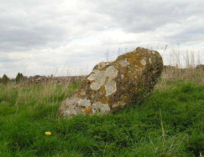
The Grickstone submitted by TheCaptain on 13th Apr 2004. Nice standing stone to the south of Grickstone farm, beside a footpath at the corner of a small wood. The stone has about 6 foot in length above ground, but due to the angle at which it leans, is only about 4 feet high. Nicely decorated with lichens. South Gloucestershire, ST777828.
(View photo, vote or add a comment)
Log Text: Nice standing stone to the south of Grickstone farm, beside a footpath at the corner of a wood. The stone is about 6 foot in height, but due to the angle at which it leans, is only about 4 feet high. Nicely decorated with lichens.
Grickstone Farm
Date Added: 6th Mar 2022
Site Type: Chambered Tomb
Country: England (Gloucestershire)
Visited: Yes on 13th Apr 2004. My rating: Condition 1
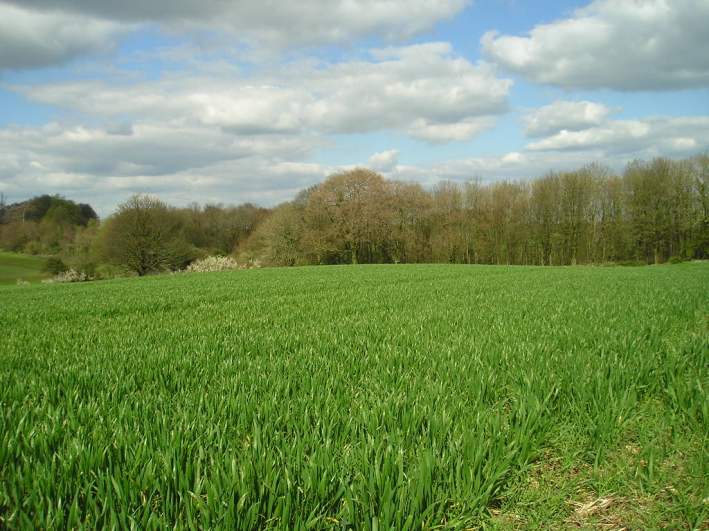
Grickstone Farm submitted by TheCaptain on 13th Apr 2004. Grickstone Farm Long Barrow, South Gloucestershire, ST783833.
This long barrow, once possibly a chambered tomb, has been completely ploughed over, leaving only slight traces of it as a gentle raise in the ground level.
(View photo, vote or add a comment)
Log Text: This long barrow has been completely ploughed over, leaving only slight traces of it as a gentle raise in the ground level
Lanhill
Date Added: 6th Mar 2022
Site Type: Long Barrow
Country: England (Wiltshire)
Visited: Yes on 13th Apr 2004. My rating: Condition 4 Ambience 3 Access 4
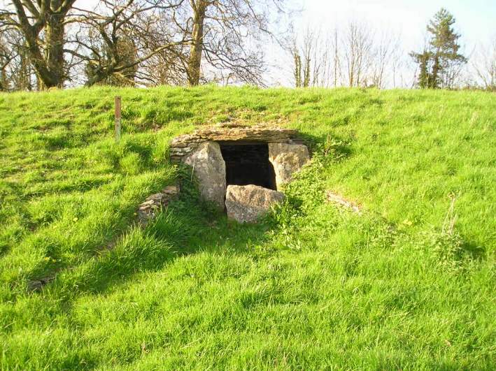
Lanhill submitted by thecaptain on 16th Apr 2004. Lanhill, Chambered Tomb, near Chippenham, Wiltshire, ST877747
At the centre of the southern side is a rock lined chamber, about 2½ m in length by 1½ metres in width, which has obviously been restored, as the roof is now supported on steel bars. The opening to the chamber has a curved, dry stone walled forecourt, and there is a blocking stone across the opening.
(View photo, vote or add a comment)
Log Text: This very nice long barrow, which lies on an east west axis, is in a field just to the south of the A420 a couple of miles east of Chippenham. The remains of the barrow still seem largely intact, and it is several metres high along its central axis. At the centre of the southern side is a rock lined chamber, about 2½ m in length by 1½ metres in width, 1m height, which has obviously been restored, as the roof is now supported on steel bars. The opening to the chamber has a curved, dry stone walled forecourt, and there is a blocking stone across the opening. Apparently, other chambers were found along the northern side of the barrow, and the remains of many skeletons were found in them.
Irons Well (Eyeworth)
Date Added: 8th Feb 2022
Site Type: Holy Well or Sacred Spring
Country: England (Hampshire)
Visited: Yes on 2nd Feb 2022. My rating: Condition 3 Ambience 2 Access 4

Irons Well (Eyeworth) submitted by JimChampion on 28th May 2006. January 2006. A view downstream from the chalybeate spring on a dull winter's day. Red ferric oxide precipitates out in the water, giving it a very orangey hue. The waters join a stream which feeds Eyeworth Pond.
(View photo, vote or add a comment)
Log Text: New Forest walk with an expected lunch stop at Fritham, but the pub was closed. Leaving we go downhill to a large pond with some serious birdwatchers, before following the stream up the valley passing a muddy area with a fenced off spring with iron rust red water burbling out of it.
Hiscocks Hill barrow
Date Added: 8th Feb 2022
Site Type: Round Barrow(s)
Country: England (Hampshire)
Visited: Yes on 2nd Feb 2022. My rating: Condition 2 Ambience 3 Access 3

Hiscocks Hill barrow submitted by TheCaptain on 8th Feb 2022. Remains of a round barrow on Hiscocks Hill on Fritham Plain Forest heathland.
(View photo, vote or add a comment)
Log Text: Walk with friends in the New Forest over heathland through an old bombing range, hunting down a few tumuli. Before we got to the (closed) pub at Fritham, I took a small detour to hunt down what is marked as tumulus on my map.
Ashley Walk mound
Date Added: 8th Feb 2022
Site Type: Artificial Mound
Country: England (Hampshire)
Visited: Yes on 2nd Feb 2022. My rating: Condition 3 Ambience 3 Access 3
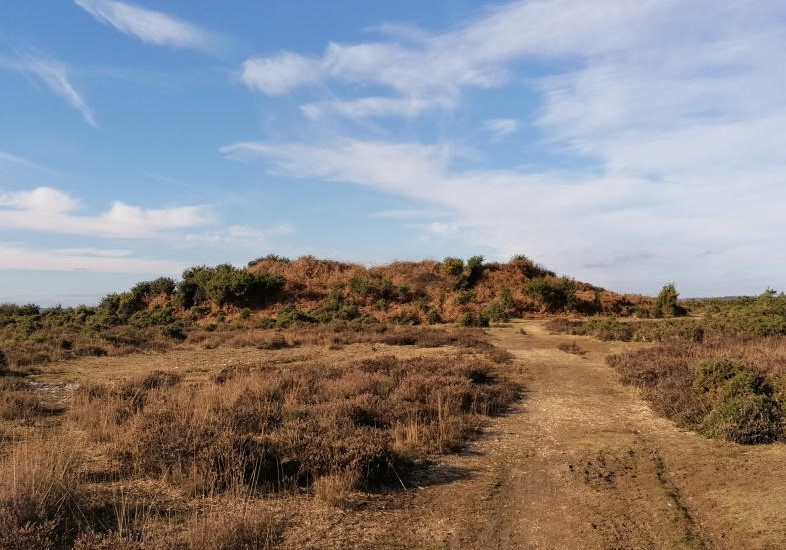
Ashley Walk mound submitted by TheCaptain on 8th Feb 2022. A large mound marked as tumulus on my OS map, possibly the earthcovered remains of the "Submarine Pens" wartime bombing range targets.
(View photo, vote or add a comment)
Log Text: Walk with friends in the New Forest over heathland through an old bombing range, hunting down a few tumuli. This large mound was marked as tumulus on the OS map, where we stopped to have lunch. This area used to be Ashley Walk bombing range during WW2 and is pockmarked with craters. I find out later that it is possible that this large mound is the earthcovered remains of the "Submarine Pens" targets.
Ashley Cross tumuli
Date Added: 8th Feb 2022
Site Type: Round Barrow(s)
Country: England (Hampshire)
Visited: Yes on 2nd Feb 2022. My rating: Condition 3 Ambience 3 Access 3

Ashley Cross tumuli submitted by JimChampion on 19th Mar 2005. March 2005. Looking north at the round barrow at SU20631431.
(View photo, vote or add a comment)
Log Text: Walk with friends in the New Forest over heathland through an old bombing range, hunting down a few tumuli. This is a nicely formed round barrow just to the west of an old bombing range lookout building on the New Forest heathland at Ashley Cross. This area used to be the Ashley Walk bombing range during WW2 and is pockmarked with craters.
The Butts (Godshill)
Date Added: 8th Feb 2022
Site Type: Round Barrow(s)
Country: England (Hampshire)
Visited: Yes on 2nd Feb 2022. My rating: Condition 2 Ambience 3 Access 3
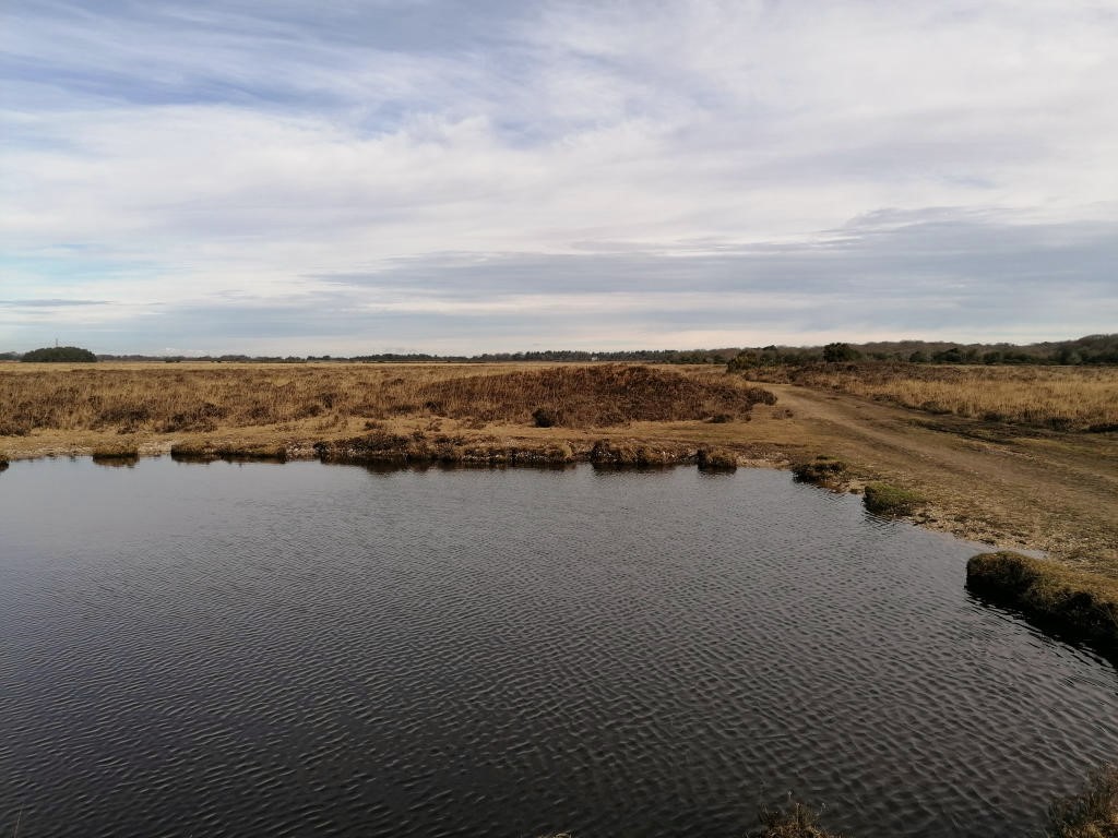
The Butts (Godshill) submitted by TheCaptain on 8th Feb 2022. The line of three can be seen beyond the pond
(View photo, vote or add a comment)
Log Text: Walk with friends in the New Forest over heathland through an old bombing range, hunting down a few tumuli, The Butts being first, three in line nearby a pond.
Leighterton Long Barrow
Date Added: 23rd Oct 2021
Site Type: Long Barrow
Country: England (Gloucestershire)
Visited: Yes on 14th Nov 2004

Leighterton Long Barrow submitted by thecaptain on 15th Nov 2004. View from the lane at the east by the village school.
(View photo, vote or add a comment)
Log Text: Massive long barrow to the east of the village of Leighterton, which can be seen walled in across a couple of fields. I could find no public access. The remains of this barrow are massive, and as is often the case, covered with trees. It looks to be one worthy of further exploration if possible.
Hetty Pegler's Tump
Date Added: 23rd Oct 2021
Site Type: Passage Grave
Country: England (Gloucestershire)
Visited: Yes on 14th Apr 2009. My rating: Condition 3 Ambience 3 Access 4

Hetty Pegler's Tump submitted by thecaptain on 15th Mar 2009. The closure notice.
(View photo, vote or add a comment)
Log Text: March 2009 and Hetty Pegler`s Tump was closed and sealed off to the public, due to concerns over its safety, with the internal drystone walling collapsing due to vandalism and the weight of the capstones resting on these walls since the 19th century reconstruction. Scaffolding has been used to prop up the chambers, and the entrance passage and courtyard sealed and filled with earth.
Soldier's Grave
Date Added: 23rd Oct 2021
Site Type: Round Barrow(s)
Country: England (Gloucestershire)
Visited: Yes on 14th Mar 2009. My rating: Condition 3 Ambience 4 Access 4
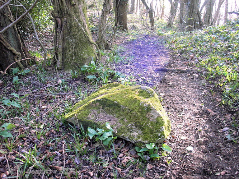
Soldier's Grave submitted by thecaptain on 10th Apr 2009. There are several fairly large bits of stone laying around nearby, which once may have formed part of the structure.
(View photo, vote or add a comment)
Log Text: This large round barrow can be found on the top of the Cotswold escarpment just into the woods at the northwest corner of the country park / picnic area, a couple of hundred yards to the north of Nympsfield long barrow. It is said to be a really unusual round barrow from the Neolithic, and not a Bronze Age round barrow at all! The top of the barrow has a very large depression in it, where it has been cut into in the past. From Grinsell - Barrows in England and Wales, “a boat-shaped hollow lined with dry-stone walling, in which were the remains of up to 44 individuals, mostly unburnt”. There are several fairly large bits of stone laying around nearby, which once may have formed part of the structure.
Nympsfield
Date Added: 23rd Oct 2021
Site Type: Long Barrow
Country: England (Gloucestershire)
Visited: Yes on 14th Mar 2009. My rating: Condition 3 Ambience 3 Access 5

Nympsfield submitted by AngieLake on 11th Oct 2015. A magical double rainbow (you can't see the upper arc here) over Nympsfield longbarrow, viewed from the rear of the mound. 22nd Sept.
(View photo, vote or add a comment)
Log Text: This Chambered long barrow with a pair of side chambers and an end chamber, is located in Coaley Peak picnic area, on the edge of the Cotswold Hills in Gloucestershire. Once covered by a mound 27m long by 18m wide and with a horned forecourt, it contained between 20 and 30 burials. These days it is an easy and pleasant place to visit, with plenty of parking, picnic areas etc nearby, and some splendid views from the edge of the Cotswold Hills over the Severn Valley below, and over to the Forest of Dean and the Welsh Hills.
The Toots (King's Stanley)
Date Added: 23rd Oct 2021
Site Type: Long Barrow
Country: England (Gloucestershire)
Visited: Yes. My rating: Condition 3 Ambience 4 Access 4

The Toots (King's Stanley) submitted by AngieLake on 21st Oct 2015. Facing WSW on 22nd Sept with the glare of the setting sun at Equinox highlighting the dips and bumps on top of The Toots. The River Severn is glimpsed in the distance, top right. Views are spectacular up here!
(View photo, vote or add a comment)
Log Text: Walking "The Selsey Circuit" of the Cotswold Way with San, and passed over the Toots. Snow on the hilltops!
The Toots (King's Stanley)
Date Added: 23rd Oct 2021
Site Type: Long Barrow
Country: England (Gloucestershire)
Visited: Yes on 14th Mar 2009. My rating: Condition 3 Ambience 4 Access 4

The Toots (King's Stanley) submitted by thecaptain on 22nd Apr 2009. The Toots - seen on the skyline of Selsley common above the church. Viewed here from Stroud
(View photo, vote or add a comment)
Log Text: Remains of a large unexcavated Long Barrow on the Cotswold escarpment slopes of Selsley Common, just to the south of Stroud in Gloucestershire. Possibly called 'The Toots' because of a hollow in the middle which makes it look as if it is composed of two mounds. The views on a good day from here are terrific, and the common is a favourite place for dogwalkers, kite flyers and model plane flying.
Belas Knap
Date Added: 23rd Oct 2021
Site Type: Long Barrow
Country: England (Gloucestershire)
Visited: Yes on 10th Aug 2021. My rating: Condition 5 Ambience 4 Access 3
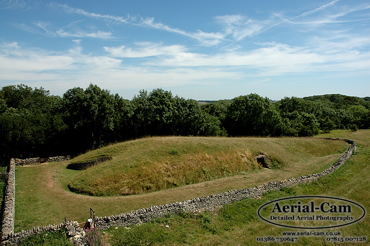
Belas Knap submitted by Adam Stanford on 19th Jul 2006. Taken with Aerial-Cam, at aprox 10M above ground level on a telescopic mast with remote control Nikon D70s camera system. This image shows the tapering of the mound from front to back (left to right). The camera was pointing in an Easterly direction. Cheers AS.
(View photo, vote or add a comment)
Log Text: A long Cotswold Way loop walk from Winchcombe, up to Belas Knap then over to Cleeve Hill via Postlip. A pint at the golf club, then up to the trig point and back to Winchcombe down the Isbourne valley.
Belas Knap
Date Added: 23rd Oct 2021
Site Type: Long Barrow
Country: England (Gloucestershire)
Visited: Yes on 2nd Apr 2006

Belas Knap submitted by Adam Stanford on 19th Jul 2006. Taken with Aerial-Cam, at aprox 10M above ground level on a telescopic mast with remote control Nikon D70s camera system. This image shows the tapering of the mound from front to back (left to right). The camera was pointing in an Easterly direction. Cheers AS.
(View photo, vote or add a comment)
Log Text: A visit to Belas Knap after a day with megalithic portal people starting at Rollright
Belas Knap
Date Added: 23rd Oct 2021
Site Type: Long Barrow
Country: England (Gloucestershire)
Visited: Yes on 6th Jul 1986

Belas Knap submitted by Adam Stanford on 19th Jul 2006. Taken with Aerial-Cam, at aprox 10M above ground level on a telescopic mast with remote control Nikon D70s camera system. This image shows the tapering of the mound from front to back (left to right). The camera was pointing in an Easterly direction. Cheers AS.
(View photo, vote or add a comment)
Log Text: A visit to Belas Knap following a visit to the fledgling Glos Warwicks Railway
