Contributory members are able to log private notes and comments about each site
Sites theCAptain has logged. View this log as a table or view the most recent logs from everyone
Birdlip Camp
Date Added: 11th Jun 2021
Site Type: Hillfort
Country: England (Gloucestershire)
Visited: Yes on 8th Jun 2021. My rating: Condition 2 Ambience 4 Access 3
Birdlip Camp submitted by 4clydesdale7 on 30th Apr 2013. S end of the Outer Bank and Ditch - the line is just discernible and proceeds from middle foreground towards the skyline and then off to the top left corner
(View photo, vote or add a comment)
Log Text: Walking the Cotswold Way north from Birdlip and the sharply pointed headland has slight remnants of a ditch and banks across the neck in these beautiful woodlands.
Crippet's Barrow
Date Added: 11th Jun 2021
Site Type: Chambered Tomb
Country: England (Gloucestershire)
Visited: Yes on 8th Jun 2021. My rating: Condition 3 Ambience 3 Access 3
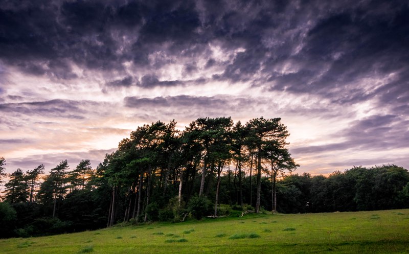
Crippet's Barrow submitted by Humbucker on 17th Mar 2018. Crippet's / Shurdington Long Barrow from the south east. I visited late afternoon in the Autumn of 2017. I had heard of very inquisitive horses in the field, but it was empty when I visited.
(View photo, vote or add a comment)
Log Text: Walking the Cotswold Way north from Crickley Hill, and I forgot to keep a look out for Crippet's Long Barrow, but at this point the footpath and separate bridleway are well fenced in, so I wouldn't have been able to get to the edge of the woodlands at the top of the hill to have a look anyway. I later got a long distance view from near the radio masts and reservoir entrance, just about making out the large barrow in its tree covered setting.
West Tump
Date Added: 10th Jun 2021
Site Type: Long Barrow
Country: England (Gloucestershire)
Visited: Yes on 31st May 2021. My rating: Condition 3 Ambience 4 Access 4
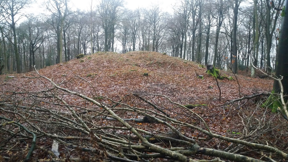
West Tump submitted by Dabberdave on 15th Jan 2017. West Tump long barrow after recent tree clearance.
(View photo, vote or add a comment)
Log Text: Walking a Cooper's Hill Circuit of the Cotswold Way from Cranham, and on the way back to Cranham I made a diversion into the woods to find this long barrow. It’s a massive lump, now mostly cleared of trees, and built in an east to west sense, significantly bigger at the eastern end, which was no doubt the main entrance.
High Brotheridge
Date Added: 10th Jun 2021
Site Type: Misc. Earthwork
Country: England (Gloucestershire)
Visited: Yes on 31st May 2021. My rating: Condition 2 Ambience 3 Access 3
High Brotheridge submitted by 4clydesdale7 on 7th Jul 2014. Inturned Banks at S Entrance
(View photo, vote or add a comment)
Log Text: Walking a Cooper's Hill Circuit of the Cotswold Way from Cranham, and passed around the western edge of this massive hilltop settlement with various bits and pieces of defensive ramparts to be seen.
Tile Well
Date Added: 10th Jun 2021
Site Type: Holy Well or Sacred Spring
Country: England (Gloucestershire)
Visited: Yes on 31st May 2021. My rating: Ambience 4 Access 3

Tile Well submitted by TheCaptain on 10th Jun 2021. Partway down the north facing hillside above the Roman Villa, is found this gushing source of crystal clear water, seemingly appearing from under the tree roots.
(View photo, vote or add a comment)
Log Text: Walking a Cooper's Hill Circuit of the Cotswold Way from Cranham, and partway down the north facing scarp, above the Roman Villa, is found this gushing source of crystal clear water, which can be heard from a fairly large distance today.
Cranham Corner Earthworks
Date Added: 10th Jun 2021
Site Type: Misc. Earthwork
Country: England (Gloucestershire)
Visited: Yes on 31st May 2021. My rating: Condition 3 Ambience 3 Access 4

Cranham Corner Earthworks submitted by TheCaptain on 10th Jun 2021. Small earthworks within the woodland at Cranham Corner.
I am not convinced they would have been of much use defensively, being on a slight slope not at the top of the hill, and not very large.
(View photo, vote or add a comment)
Log Text: Walking a Cooper's Hill Circuit of the Cotswold Way from Cranham, and first off had a look at these small earthworks. I am not convinced they would have been of much use defensively, being on a slight slope not at the top of the hill, and not very large.
Brackenbury Ditches
Date Added: 25th Apr 2021
Site Type: Promontory Fort / Cliff Castle
Country: England (Gloucestershire)
Visited: Yes on 24th Apr 2021. My rating: Condition 3 Ambience 5 Access 3

Brackenbury Ditches submitted by Humbucker on 16th Jun 2020. The footpath along the ridge of The West Woods follows the ramparts to Brackenbury Ditches on this section from North Nibley to Wotton Under Edge.
(View photo, vote or add a comment)
Log Text: Beautiful sunny morning walk from Wotton-under-Edge, up and over to Waterley Bottom down the valley to join the Cotswold Way and head up through North Nibley and up the steep Cotswold Edge to the Tyndale Monument. Then all along the edge of the hills, through beautiful bluebell, wild garlic and anemone filled woods, taking in the atmospheric old iron age fort of Brackenbury Ditches before out into the open above Wotton, dropping steeply down into the town for a pint in The Star.
Bellever Tor 3
Date Added: 29th Jan 2021
Site Type: Cairn
Country: England (Devon)
Visited: Yes on 18th Sep 2020. My rating: Condition 2 Ambience 3 Access 3
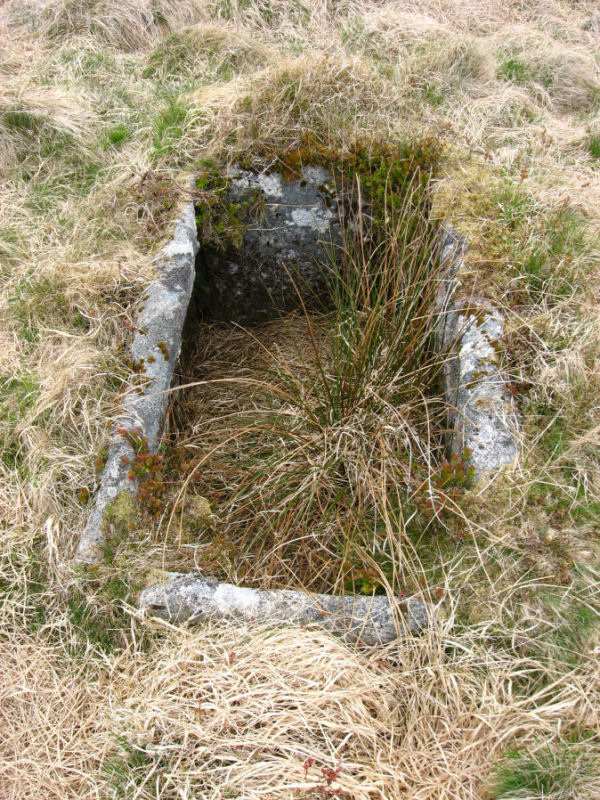
Bellever Tor 3 submitted by Anne T on 13th Oct 2016. The Black Newtake North 1 cist, submitted on behalf of Prehistoric Dartmoor Walks.
(View photo, vote or add a comment)
Log Text: A long and difficult walk through long grass on very uneven ground to try and find this marked on the map as "Cist", which I only found using the gps. I found a single standing stone which I thought must be it, but then while taking photos I almost fell into the cist nearby!
Pierre Couverte de Bué
Trip No.205 Entry No.269 Date Added: 13th Dec 2020
Site Type: Burial Chamber or Dolmen
Country: France (Centre:Indre (36))
Visited: Yes on 27th Sep 2005. My rating: Condition 4 Ambience 5 Access 4
Pierre Couverte de Bué submitted by theCaptain on 14th Dec 2010. A couple of kilometres to the southeast of the village of Bagneux near to the hamlet of Bué, can be found this dolmen in a lovely situation in the forest.
(View photo, vote or add a comment)
Log Text: A couple of kilometres to the southeast of the village of Bagneux near to the hamlet of Bué, can be found this dolmen in a lovely situation in the forest. The dolmen is well signposted from all around, and from a parking place at Bué it is about 400 metres walk. The large capstone, 6m by 4m sits on top of a chamber 5m by 3m. It has a backstone and six sidestones in various positions of uprightness. The capstone is between 1 and 1.5 metres above the ground.
It has got its own bench nearby on which to sit and contemplate, with falling acorns a hazard, and a woodpecker pecking away amongst other things. This really is a lovely spot, and so gets a 5 for ambience.
I will make this my last megalithic site on my 6 months trip round France, it really is a nice place to finish on, and an unexpected dolmen at that.
It is now 2:30pm, and I really ought to be getting on driving back towards my sister's. Romorantin, Blois (roadworks), Vendome (Roadworks, big crane, school traffic), St-Calais (terrible traffic), Le Mans (rain, traffic jams), Alencon (slow traffic), Argentan, Flers (dug up, closed roads, diversions within diversions). It takes forever to find Vire, now in the complete dark, St-Lo (more diversions) and finally back to Sara's at about 9:30pm. I was amazed I didn't get tired or dozy at all while driving. Parked with 117630 km on the clock, 545 for today. Sausages and eggs (yummy), large beer, then to bed after seeing a depressing news on the telly. I've not missed missing all the bad news from around the world while away in my campervan.
Tréfoux deux menhirs
Trip No.205 Entry No.267 Date Added: 13th Dec 2020
Site Type: Standing Stones
Country: France (Centre:Indre (36))
Visited: Yes on 27th Sep 2005. My rating: Condition 3 Ambience 4 Access 4

Tréfoux deux menhirs submitted by thecaptain on 19th Sep 2008. Near to a corner in the road are two standing rocks, which are clearly not naturally like that. One is about 1 metre tall, the other about 1.2 metres tall.
(View photo, vote or add a comment)
Log Text: Marked on my ign map to the southeast of Bagneux are menhirs. Driving along the little road that passes them is lots of what looks like natural stone outcropping, and perhaps the remains of a dolmen. However, near to a corner in the road are two standing rocks, which are clearly not naturally like that. One is about 1 metre tall, the other about 1.2 metres tall. Around them are many more rocks. It is not difficult to see what is perhaps an alignment of 5 or 6 rocks with others fallen. Or perhaps it is the remains of an allée couverte type structure. I am not sure exactly what is going on here, but it is a nice spot in the forest. A bit further along the road to the west is what seems to be the remains of another fallen menhir or two.
Pierre Levée (Liniez)
Trip No.205 Entry No.264 Date Added: 13th Dec 2020
Site Type: Passage Grave
Country: France (Centre:Indre (36))
Visited: Yes on 27th Sep 2005. My rating: Condition 4 Ambience 3 Access 5
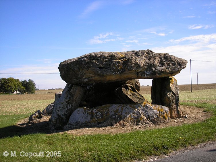
Pierre Levée (Liniez) submitted by thecaptain on 16th Jan 2009. The back cell of the chamber is still all nicely erect, making this a pleasant monument to visit. It is all orientated towards the east at 070°.
(View photo, vote or add a comment)
Log Text: Just outside the village of Liniez, along the D.926 road towards Vatan, and to the right of the road can be seen the remains of this allée couverte. It was probably an Angevin type allée couverte, but there are no obvious remains of the porchway. The remains of the chamber are 10 metres long by 4 metres wide, and it was probably covered by four capstones, of which three remain in various positions, from still in place at the back end, sloping in the middle and flat on the ground at the front. Several side slabs remain, as does the backslab, and there is evidence of a possible internal partition, although it could be bits of broken capstone. The back cell of the chamber is still all nicely erect, making this a pleasant monument to visit. It is all orientated towards the east at 070°.
La Pierre Dolmen
Trip No.205 Entry No.261 Date Added: 13th Dec 2020
Site Type: Burial Chamber or Dolmen
Country: France (Centre:Indre (36))
Visited: Yes on 27th Sep 2005. My rating: Condition 3 Ambience 4 Access 4
La Pierre dolmen submitted by theCaptain on 16th Dec 2010. What I found here is probably the remains of an Angevin dolmen, made with a single backstone, two sidestones each side with two capstones, the rear one in place, the forward one broken and fallen into the chamber.
There are signs of an entry portal, now all a bit broken.
(View photo, vote or add a comment)
Log Text: It was a bit of a struggle to find this, due to several of the roads being closed for some reason. However, take the D.23 road southwest from Moulins-sur-Céphons towards St Martin-de-Lamps. About midway between the two is the hamlet of La Pierre, and there are signs to the dolmen. It is about 800 metres walk from the road, round the back of the houses.
What I found is probably the remains of an Angevin dolmen with a large 6 m by 3 m chamber, made with a single backstone, two sidestones each side with two capstones, the rear one in place, the forward one broken and fallen into the chamber. There are signs of an entry portal, now all a bit broken. Some of the stones are massive thick chunks, not nice slim slabs.
Pierre du Tombeau
Trip No.205 Entry No.260 Date Added: 13th Dec 2020
Site Type: Standing Stone (Menhir)
Country: France (Auvergne:Puy-de-Dôme (63))
Visited: Yes on 26th Sep 2005. My rating: Condition 4 Ambience 2 Access 5
Pierre du Tombeau submitted by thecaptain on 13th Oct 2006. Pierre du Tombeau, Davayat menhir, Montotoute menhir. Take your pick for its name.
A little sign near to the menhir.
(View photo, vote or add a comment)
Log Text: Right in the middle of the village of Davayat, near to the traffic lights, this menhir resides in amongst the houses, and is half hidden in a garden yard. It is 4.8 metres high, leaning nicely, and is one of the biggest menhirs in the Auvergne region.
The menhir is perhaps lucky to survive right here between the houses, and in many respects perhaps owes its survival to it being seen as an important and sacred monument throughout history by the inhabitants of the village. There was once another large menhir nearby, but traces of this can no longer be found, it falling victim to agricultural "progress".
Dolmen du Chausse
Trip No.205 Entry No.258 Date Added: 13th Dec 2020
Site Type: Burial Chamber or Dolmen
Country: France (Auvergne:Cantal (15))
Visited: Yes on 26th Sep 2005. My rating: Condition 4 Ambience 3 Access 4

Dolmen du Chausse submitted by thecaptain on 23rd Nov 2008. This little dolmen is still mostly contained within its large cairn of stones, except that it has been dug into from the southern side.
(View photo, vote or add a comment)
Log Text: Signposted as tumulus from the village of Mons, just to the east of junction 28 of the A.75 Autoroute near to St Flour. The trackway leads you back over the A.75 and then about another 300 metres. It is probably possible to drive to it, but I parked and walked.
The little dolmen is still mostly contained within its large cairn of stones, except that it has been dug into from the southern side. The cairn is about 16 metres in diameter and 2 metres high, made of loose small volcanic rocks. The dolmen has a capstone 3m by 2m sat on top of a chamber 2m by 1m, with two side slabs but no obvious backstone.
The chamber is full of rocks, and opens southwards with fine views, spoiled slightly by the A.75 motorway screaming past ! A nice place to visit, with lots of yellow mullens growing on and around. Apparently there are many legends attached to this tomb, but I am not sure what any of them are.
Bois-Grand Dolmen
Trip No.205 Entry No.257 Date Added: 13th Dec 2020
Site Type: Burial Chamber or Dolmen
Country: France (Auvergne:Cantal (15))
Visited: Yes on 26th Sep 2005. My rating: Condition 4 Ambience 3 Access 4
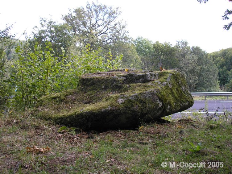
Bois-Grand dolmen submitted by thecaptain on 5th Nov 2008. Seen here in its position right at the edge of the cutting for the new road.
(View photo, vote or add a comment)
Log Text: Just to the south of the village of Les Ternes, the new D.921 road goes up a fairly steep hill. On the right, halfway up the hill is a little layby and picnic table, with a sign to this dolmen, which can then be found less than 50 metres up the trackway from the layby. It is right beside the road, and part of its mound of stones has been cut away. The dolmen has a large and thick capstone, 3.5 metres by 2.5 metres, sitting on top of a little chamber, 2m by 1m, which has two side slabs and a back stone still nicely in place. The capstone looks much too large for the rest of the dolmen ! Around the dolmen are lots of loose basalt stones, obviously one a part of its cairn.
Bargueyrac Menhir
Trip No.205 Entry No.256 Date Added: 13th Dec 2020
Site Type: Standing Stone (Menhir)
Country: France (Auvergne:Cantal (15))
Visited: Yes on 26th Sep 2005. My rating: Condition 3 Ambience 3 Access 5
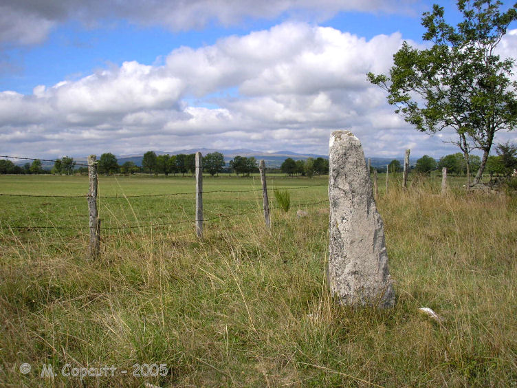
Bargueyrac Menhir submitted by thecaptain on 3rd Nov 2008. West of the village of Sériers, along the new D.990 road towards Pierrefort can be found this little menhir, right beside the road and with a little sign.
(View photo, vote or add a comment)
Log Text: About half a kilometre further west along the D.990 road can be found this little menhir, right beside the road and with a little sign. Its only about 1.3 metres tall basalt, and in the past has obviously had something stuck on top, probably a cross, due to the hole which can be seen drilled into it.
La Table au Loup
Trip No.205 Entry No.255 Date Added: 13th Dec 2020
Site Type: Burial Chamber or Dolmen
Country: France (Auvergne:Cantal (15))
Visited: Yes on 26th Sep 2005. My rating: Ambience 3 Access 4
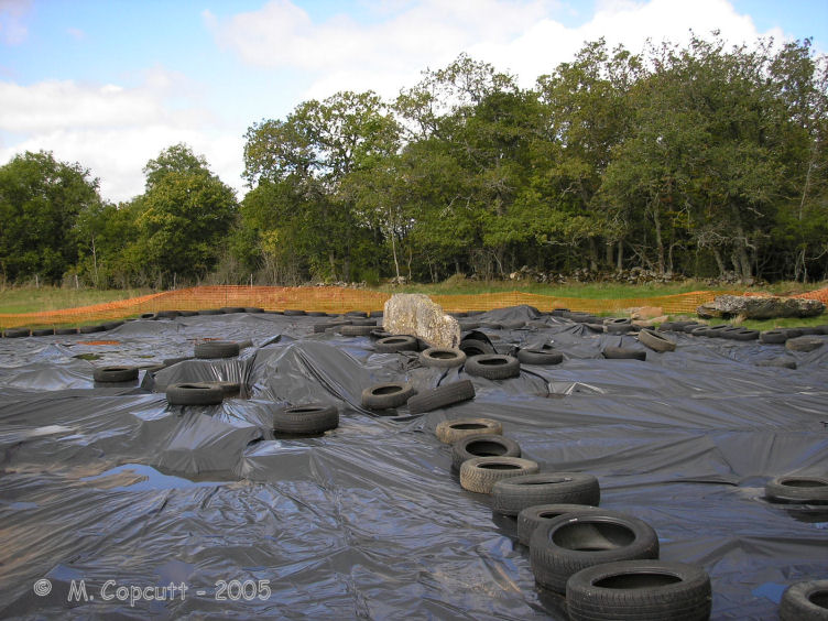
La Table au Loup submitted by thecaptain on 4th Nov 2008. The dolmen was undergoing excavation when I visited in 2005, and apart from a large side slab sticking up out of the middle, and obvious remains of a mound, there was nothing much I could see here.
(View photo, vote or add a comment)
Log Text: West of the village of Sériers, along the new D.990 road towards Pierrefort, about 500 metres from the junction with the D.921 is a sign for the dolmen. It is then about an 800 metre walk along a signposted gravel trackway across marshy land before you reach the dolmen, or as I found, a fenced off plastic sheeting covered area! The dolmen was undergoing excavation, and apart from a large side slab sticking up out of the middle, and obvious remains of a mound, there was nothing I could see here.
Menhir de la Croix-Grosse
Trip No.205 Entry No.254 Date Added: 13th Dec 2020
Site Type: Standing Stone (Menhir)
Country: France (Auvergne:Cantal (15))
Visited: Yes on 26th Sep 2005. My rating: Condition 5 Ambience 4 Access 5
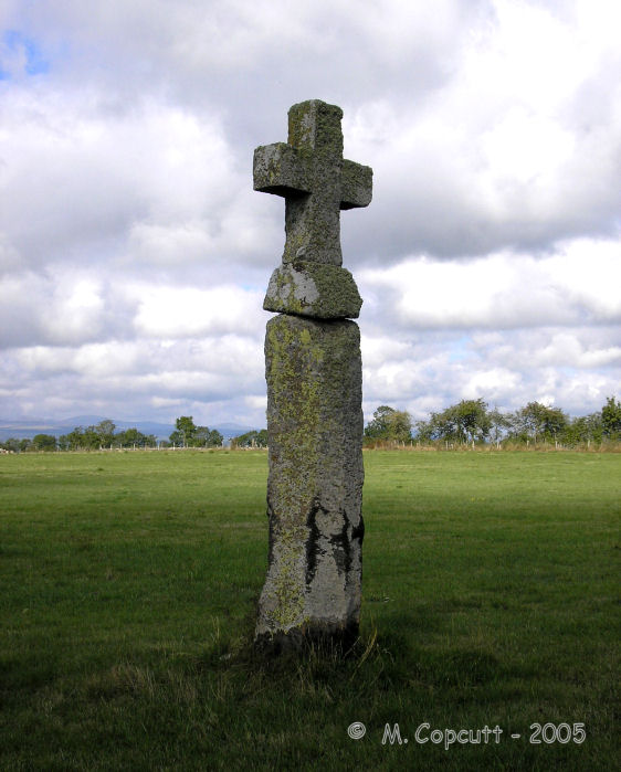
Menhir de la Croix-Grosse submitted by thecaptain on 31st Oct 2008. This christianised menhir stands just on the western outskirts of the village of Sériers, and is along the road to Peyrelade (no doubt once home to its own megalith).
(View photo, vote or add a comment)
Log Text: This christianised menhir stands just on the western outskirts of the village of Sériers, and is signposted from there as Menhir Christianisée, and is along the road to Peyrelade (no doubt once home to its own megalith). There is a large basalt carved cross sat on top of a superb column of christalline basalt, octagonal and well over 2 metres high. With its cross, it stands a good 3.5 metres tall. This really is a lovely monument, the basalt column is perfectly upright, and always has been, its never been restored. Apparently the column must have been brought here from several kilometres away, so its obviously at a once very special place.
Pierre Levée dolmen 2 (Villedieu)
Trip No.205 Entry No.253 Date Added: 13th Dec 2020
Site Type: Burial Chamber or Dolmen
Country: France (Auvergne:Cantal (15))
Visited: Yes on 26th Sep 2005. My rating: Condition 2 Ambience 4 Access 3
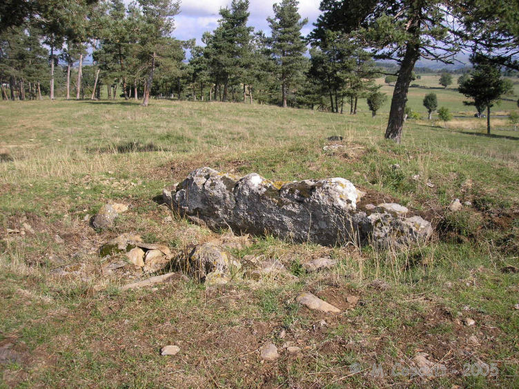
Pierre Levée dolmen 2 (Villedieu) submitted by thecaptain on 19th Dec 2008. The dolmen is in very poor condition, basically one large side slab in a hollow in the centre of its tumulus.
(View photo, vote or add a comment)
Log Text: Unfortunately, this cannot be reached from its near neighbours, and instead it has to be walked to quite a distance (about 1 km) from a point where you start the walk to the Tombe du Capitaine. It's a pleasant walk along a well signposted track, and then across a hilltop field.
The dolmen is in very poor condition, basically one large side slab in a hollow in the centre of its tumulus. However, the tumulus is in fine condition, about 15 metres in diameter and up to 1.5 metres in height. Around the outside at certain places it seems to be encircled with a sort of stone slab walling. This is in a lovely spot, and was well worth the effort to get to. I wouldn't be surprised if there was once another dolmen in this mound.
Pierre Levée dolmen 1 (Villedieu)
Trip No.205 Entry No.252 Date Added: 13th Dec 2020
Site Type: Burial Chamber or Dolmen
Country: France (Auvergne:Cantal (15))
Visited: Yes on 26th Sep 2005. My rating: Condition 2 Ambience 3 Access 5
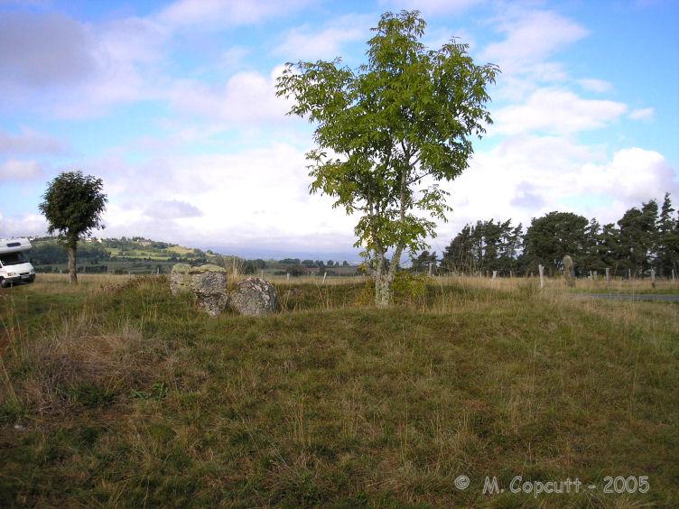
Pierre Levée dolmen 1 (Villedieu) submitted by thecaptain on 19th Dec 2008. There is still quite a respectable mound of small stones, diameter about 12 metres, surrounding the remains of the dolmen, but the megalithic chamber has been largely destroyed, leaving not much more than a hollow in the centre of the tumulus.
(View photo, vote or add a comment)
Log Text: The remains of this dolmen can be found just to the east of the D.44 road, about 30 metres from the menhir. There is still quite a respectable mound of small stones, diameter about 12 metres, surrounding the remains of the dolmen, but the megalithic chamber has been largely destroyed, leaving not much more than a hollow in the centre of the tumulus. One large side slab and an entry stone are all that obviously remain in place.
