Contributory members are able to log private notes and comments about each site
Sites theCAptain has logged. View this log as a table or view the most recent logs from everyone
Monument 280
Date Added: 5th Nov 2023
Site Type: Ring Cairn
Country: Wales (Conwy)
Visited: Yes on 13th Sep 2023. My rating: Condition 3 Ambience 4 Access 2
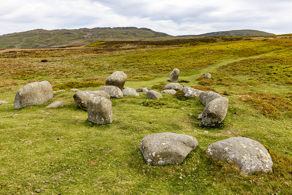
Monument 280 submitted by nigeynoo on 21st May 2018. Monument 280 taken May 20 on a very peaceful afternoon
(View photo, vote or add a comment)
Log Text: Over a couple of mounds, and there is another catchily named site, Monument 280, of which I have no idea what type of site this is. There are many stones stood and arranged, but with no obvious pattern. There is a circle in the middle of them, and several in a straight line through the middle. Is that a burial cist beside one of the large stones? I see online something which states that in 1845 this was described as three circles. Time for lunch, and I notice a pair of glasses within what looks to me like a burial cist, with a leather strap hanging over the large stone beside it.
Montségur museum
Trip No.200 Entry No.24 Date Added: 18th Jun 2020
Site Type: Museum
Country: France (Midi:Ariège (09))
Visited: Yes on 24th Mar 2000. My rating: Access 4
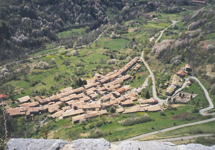
Montségur museum submitted by thecaptain on 16th Feb 2005. Montségur village. Looking down onto the village from the walls of the hilltop castle. There is an interesting museum in the village with all sorts of ancient stuff found here contained within.
(View photo, vote or add a comment)
Log Text: Small museum with lots of items in the village of Montségur below the sacred hill known as Le Pog.
Montségur
Trip No.200 Entry No.23 Date Added: 18th Jun 2020
Site Type: Ancient Village or Settlement
Country: France (Midi:Ariège (09))
Visited: Yes on 24th Apr 2000. My rating: Condition 3 Ambience 5 Access 3
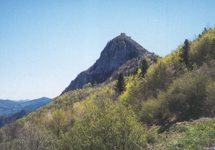
Montségur submitted by thecaptain on 16th Feb 2005. Montségur Pog. The castle where the last stand of the Cathars took place against the Catholic Church can be seen here on top of the sacred hill known as the Pog. More than 200 unarmed Parfaits were defeated and burned here in 1244.
However, the Pog, seen here from the northwest, has been inhabited since neolithic times.
(View photo, vote or add a comment)
Log Text: A lovely sunny day to explore. Puivert castle. Fontestorbes. Montsegur Castle. Pass de ? closed. Plain de ? Ax-les-Thermes, Col de Portel, scary roads. Mas D’Azil. Toulouse late.
Ancient defended settlement on top of the sacred hill known as The Pog at Montségur in Ariège. Although the main remains of the castle date back to the time of the Cathars, there is plenty of evidence that this hill has been inhabited since time immemorial. There is a little museum with lots of items in the village below the Pog.
Montségur is more well known as the site of the slaughter of the last of the Cathars by the catholic church in 1244, where after a long siege, 200 unarmed Cathar Parfaits were defeated and burned in a pyre by an army numbering 10,000. The Castle dungeon has a strange solar event each summer solstice, as the first rays of the rising sun shine right through the two arrow slots on one side, and straight out through two others on the far side. Was this built into it deliberately ? One might be a fluke, but two ?
Montségur
Trip No.200 Entry No.36 Date Added: 18th Jun 2020
Site Type: Ancient Village or Settlement
Country: France (Midi:Ariège (09))
Visited: Yes on 14th May 2000

Montségur submitted by thecaptain on 16th Feb 2005. Montségur Pog, seen here from the southwest, has been inhabited and defended since neolithic times.
But it is more well known for its Cathar castle, and as the site of the slaughter of the last of the Cathars by the catholic church in 1244.
The Castle dungeon has a strange solar event each summer solstice, as the first rays of the rising sun shine right through the two arrow slots on one side, and straight out through two others on the far side. Was this built into it deliberately ? One mi...
(View photo, vote or add a comment)
Log Text: Dad over to Toulouse for a long weekend. Explore Mirepoix. Montsegur, Couiza, Rennes-le-Chateau, very strange place. Gorges St George upper Aude valley, Col de Pailleres (2001m). Ax-les-Thermes, Tarascon, Foix, and back to Toulouse.
Montmirat menhirs
Trip No.205 Entry No.221 Date Added: 6th Dec 2020
Site Type: Standing Stones
Country: France (Languedoc:Lozère (48))
Visited: Yes on 25th Sep 2005. My rating: Condition 3 Ambience 3 Access 5
Montmirat menhirs submitted by ocdolmen on 29th Aug 2006. The menhir of the Col de Montmirat is the only survivor of an initial group of 9 menhirs. It was christianized with the installation of an iron cross at the top of the stone. The holes on the stone are old tests of cutting up by carriers. Height: 1.70 meter.
With a few meters from there, one can see the vestiges of 2 broken and cut down menhirs.
(View photo, vote or add a comment)
Log Text: At the top of the Col de Montmirat, on the main road from Florac to Mende, can be found this menhir. It is just beside the road which goes west towards Montmirat hamlet, at an altitude of 1050m. About 2 metres tall, it has an iron cross mounted on top of it, and has also been used as a roadsign in the past. Supposedly it is the only survivor of a group of menhirs once here.
Montjoie de la Can de l'Hospitalet D
Trip No.205 Entry No.216 Date Added: 1st Dec 2020
Site Type: Marker Stone
Country: France (Languedoc:Lozère (48))
Visited: Yes on 24th Sep 2005. My rating: Access 5
Montjoie de la Can de l'Hospitalet D submitted by regina on 24th Dec 2020. Site in Languedoc:Lozère (48) France
(View photo, vote or add a comment)
Log Text: Seen while driving north along the Corniche-des-Cévennes road passing over the high ground to the north of Le Pompidou.
Montjoie de la Can de l'Hospitalet C
Trip No.205 Entry No.217 Date Added: 1st Dec 2020
Site Type: Marker Stone
Country: France (Languedoc:Lozère (48))
Visited: Yes on 24th Sep 2005. My rating: Access 5
Montjoie de la Can de l'Hospitalet C submitted by regina on 24th Dec 2020. Site in Languedoc:Lozère (48) France
(View photo, vote or add a comment)
Log Text: Seen while driving north along the Corniche-des-Cévennes road passing over the high ground to the north of Le Pompidou.
Montjoie de la Can de l'Hospitalet A
Trip No.205 Entry No.218 Date Added: 1st Dec 2020
Site Type: Marker Stone
Country: France (Languedoc:Lozère (48))
Visited: Yes on 24th Sep 2005. My rating: Access 5
Montjoie de la Can de l'Hospitalet A submitted by regina on 22nd Dec 2020. Site in Languedoc:Lozère (48) France
(View photo, vote or add a comment)
Log Text: Seen while driving north along the Corniche-des-Cévennes road passing over the high ground to the north of Le Pompidou.
Montezuma Castle
Date Added: 18th Sep 2010
Site Type: Ancient Village or Settlement
Country: United States (The Southwest)
Visited: Yes on 25th May 2009
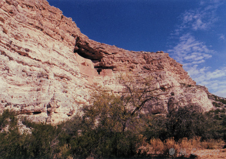
Montezuma Castle submitted by thecaptain on 25th May 2009. Montezuma Castle, on a hot day in November 1990.
(View photo, vote or add a comment)
Log Text: None
Montemain stone
Trip No.204 Entry No.267 Date Added: 11th Sep 2020
Site Type: Polissoir
Country: France (Centre:Eure-et-Loire (28))
Visited: Yes on 8th Aug 2005. My rating: Condition 3 Ambience 4 Access 4
Montemain stone submitted by theCaptain on 2nd Apr 2012. On the top can be seen two grooves and three large flattish polishing areas, while further down there are another two basin type areas.
(View photo, vote or add a comment)
Log Text: Driving through the village of Saumeray, I saw a sign to Polissoir, so stopped for a look. Right in the middle of the village, on a little green square behind the church can be found this combination menhir and polissoir. There is a little board stating that the stone was moved here in 1998 after being found in a "ballastiere" (gravel pit) at nearby Montemain.
It is thought that the stone was once a menhir which had fallen and was used after that as a polishing stone. The stone itself is a big block of yellowish coloured rock mixed with puddingstone, and is about 4 metres long, 1.5 metres wide and high. On the top of it can be seen two grooves and three large flattish polishing areas, while further down there are another two basin type areas. This was a nice find which I was not expecting.
Monte à Peine menhir
Trip No.204 Entry No.242 Date Added: 6th Sep 2020
Site Type: Standing Stone (Menhir)
Country: France (Centre:Loiret (45))
Visited: Yes on 6th Aug 2005. My rating: Condition 3 Ambience 3 Access 5
Monte à Peine menhir submitted by thecaptain on 16th Feb 2007. Monte à Peine menhir is right beside the road, but almost lost in bushes and undergrowth.
It's just over 2 metres tall, and looks to be a lump of sarsen type stone.
(View photo, vote or add a comment)
Log Text: Take Rue du Menhir east from the village of Pers-en-Gâtinais, and just after the first road junction the road bears round to the right. The menhir is right beside the road, but almost lost in bushes and undergrowth. It's just over 2 metres tall, and is a lump of sarsen type stone.
Montchauvet Alignements
Date Added: 29th Oct 2019
Site Type: Standing Stones
Country: France (Normandie:Calvados (14))
Visited: Yes on 29th Oct 2012
Montchauvet alignements submitted by theCaptain on 29th Oct 2012. I found nine large stones in the field, mostly flat to the ground, but one or two upright.
(View photo, vote or add a comment)
Log Text: None
Mont-Dol
Date Added: 29th Oct 2019
Site Type: Ancient Temple
Country: France (Bretagne:Ille-et-Vilaine (35))
Visited: Yes on 23rd Oct 2010
Mont-Dol submitted by TheCaptain on 23rd Oct 2010. Mont Dol is a large granite rock outcrop, dramatically jutting up through the flat coastal marshlands of the Baie de Mont St-Michel to the north of the ancient city of Dol-de-Bretagne, and in some ways is rather like Mont St-Michel itself, although nowadays completely enclosed within farmed lands.
(View photo, vote or add a comment)
Log Text: None
Mont-de-Sène dolmen 1
Trip No.204 Entry No.207 Date Added: 27th Aug 2020
Site Type: Burial Chamber or Dolmen
Country: France (Bourgogne:Saône-et-Loire (71))
Visited: Couldn't find on 3rd Aug 2005
Log Text: Remains of at least three dolmens and their mounds are to be found on the slopes of Mont-de-Sène, high up above the village of Dezize-les-Maranges.
Mont St Michel
Trip No.212 Entry No.13 Date Added: 13th Jun 2020
Site Type: Ancient Village or Settlement
Country: France (Normandie:Manche (50))
Visited: Yes on 11th Oct 2012. My rating: Condition 5 Ambience 4 Access 4
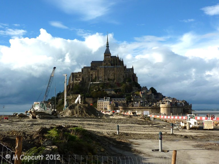
Mont St Michel submitted by theCaptain on 4th Jan 2013. They are trying to cut off the Mont again, to get the sea to surround it once more, and this involves removing the old causeway which prevented the tide clearing the silts etc, and just have a bridge going out to the Mont. This and alterations to the river should then mean the silts get washed away, and the sea once more claims the Mont at each high tide.
(View photo, vote or add a comment)
Log Text: Getting a late lunch at Plein Fougeres, it is now much too late to go to Fougeres and have a proper look round, so we decide to go to Mont St Michel for a quick look around. Shouldn't be too busy at this time of year. It has all changed since either myself or Dad was last there, and you now have to park miles away, at what is becoming a sort of holiday village resort. Many huge car parks, some hotels and restaurants etc, and a 40 min walk to the Mont, but free shuttle busses are provided. At this point I was ready to give up and drive away, but Dad still wanted to persevere, so we got the shuttle bus 10 mins out to the Mont.
Theres a hell of a lot of work going on here, both to the walls and the surroundings. Turns out they are trying to cut off the Mont again, to get the sea to surround it once more, and this involves removing the old causeway etc, and just have a sort of bridge going out to the Mont. This and alterations to the river should then mean the silts get washed away, and the sea once more claims the Mont at each high tide. I read at the new controlling dam on the river that the land has risen 4.9 metres since the 1960s. Much of these new grassy marshes is being dug up and pushed into the river, hopefully to get washed away.
The place is not too crowded, although many Japanese here, so we walk up to the abbey along the main street, no time to do the tour. Walk down around the outer walls, watching the tide coming in, and theres a group of people out walking over the sands and mud with the water coming in. Just as we leave the Mont, the sun starts to come out, making a few pictures much better.
Cup of tea, then on to Sara's, much later than we ought to be, but this time its not all my doing! Must visit here properly sometime, October Thursday mornings might be OK, but need the whole day.
Mont St Michel
Trip No.203 Entry No.604 Date Added: 13th Jun 2020
Site Type: Ancient Village or Settlement
Country: France (Normandie:Manche (50))
Visited: Yes on 28th Jun 2005. My rating: Condition 5 Ambience 2 Access 4
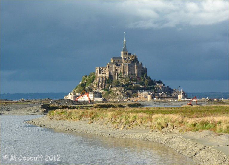
Mont St Michel submitted by theCaptain on 4th Jan 2013. They are trying to cut off the Mont again, to get the sea to surround it once more.
I read at the new controlling dam on the river that the land has risen 4.9 metres since the 1960s. Much of these new grassy marshes is being dug up and pushed into the river, hopefully to get washed away.
(View photo, vote or add a comment)
Log Text: Far too hot and busy and crowded.
Mont Joly
Trip No.202 Entry No.13 Date Added: 26th Mar 2020
Site Type: Ancient Village or Settlement
Country: France (Normandie:Calvados (14))
Visited: Yes on 23rd Apr 2005. My rating: Condition 2 Ambience 4 Access 5

Mont Joly submitted by TheCaptain on 7th May 2005. Mont Joly, Soumont-Saint-Quentin, Calvados.
This is a promontory site surrounded on three sides by the steep gorge of the river Laizon. The site has been inhabited and defended since Paleolithic times, and artefacts have been found from all times since this. It is said that although little ancient remains can be seen, they are everywhere underfoot, and every molehill will contain several flints and pottery sherds.
(View photo, vote or add a comment)
Log Text: This is a promontory site surrounded on three sides by the steep gorge of the river Laizon and the eastern end has been defended by ramparts little of which can now be seen between the church and water tower. The site has been inhabited and defended since Paleolithic times and artefacts have been found from all times since this. It is said that although little ancient remains can be seen they are everywhere underfoot and every molehill will contain several flints and pottery sherds. This region was a major supplier of flint tools in the past and there is much to be found here.
Mont Joly
Trip No.212 Entry No.8 Date Added: 26th Mar 2020
Site Type: Ancient Village or Settlement
Country: France (Normandie:Calvados (14))
Visited: Yes on 7th May 2012. My rating: Condition 2 Ambience 4 Access 5
Mont Joly submitted by theCaptain on 15th Jan 2014. This promontory site is surrounded on three sides by the steep gorge of the river Laizon, and the eastern end has been defended by ramparts, a little of which can now be seen between the church and water tower.
In this picture a raise in the land can be seen to the left of my Dad.
(View photo, vote or add a comment)
Log Text: What an intriguing place this is, and deserving of much more thorough exploration.
Mons Dolmen 2
Trip No.203 Entry No.144 Date Added: 10th Apr 2020
Site Type: Burial Chamber or Dolmen
Country: France (Midi:Lot (46))
Visited: Couldn't find on 24th May 2005
Mons dolmen 2 submitted by ocdolmen on 26th Nov 2006. another view of Mons 2 dolmen , november 2006
(View photo, vote or add a comment)
Log Text: Supposedly another 500 metres along the path across the fields beside the railway can be found this nice little dolmen with a 3.5 by 1.5 metre chamber, within a round mound. But time was getting on, and there was no obvious way to get much further along into the fields without climbing fences and walls, and walking through cropped fields. This area was not proving very helpful for finding dolmens, so I decided to give up and move on.
Mons dolmen 1
Trip No.203 Entry No.143 Date Added: 10th Apr 2020
Site Type: Burial Chamber or Dolmen
Country: France (Midi:Lot (46))
Visited: Yes on 24th May 2005. My rating: Condition 3 Ambience 3 Access 3
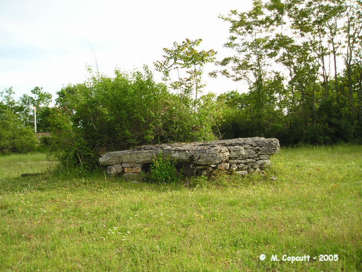
Mons dolmen 1 submitted by thecaptain on 7th Nov 2005. Mons dolmen 1.
A bit of a devil to find near the village of Asier in Lot. There are several dolmens, a menhir and a couple of tumuli in the fields around here, but this was the only one I could find, without crossing fences, walls and cropped fields.
(View photo, vote or add a comment)
Log Text: In the Champ de Belair, to the northwest of the village of Assier, on the opposite (northwestern) side of the railway to the previous dolmens, are supposedly 4 dolmens, 2 tumulus and a menhir to be seen. But they don’t get any easier to find. Follow the trackway along the northern side of the railway, in a northwesterly direction for about a kilometre from the station. The track gradually fades out into an overgrown grassy path, with bushes everywhere, before completely fading away into nothing. In a field to the left of the path, having passed through some dense scrub and across a wall, I eventually found the first dolmen.
A 4 metre long by 2 metres wide capstone sits on top of a bit of a wreck of a chamber, orientated at about 115°. The chamber seems to be made from a mix of slabs and dry stones, but its possible that the slabs are just crumbling, and the capstone has been held up by stones placed underneath it.
