Contributory members are able to log private notes and comments about each site
Sites theCAptain has logged. View this log as a table or view the most recent logs from everyone
Dolmen dit Collets de Collioure
Trip No.200 Entry No.52 Date Added: 17th Jun 2020
Site Type: Burial Chamber or Dolmen
Country: France (Languedoc:Pyrénées-Orientales 66)
Visited: Yes on 26th Jun 2000. My rating: Access 3
Log Text: Weekend to explore Collioure area. Drive coast road Port Vendres, Banyuls-sur-Mer, Cerbere, into Spain, Portbou, Platja de Garbet to Figueras. Beautiful but slow. Signs to dolmens. Dali Museum brilliant. Back to Collioure through mountains, Argeles-sur-Mer. Look for the dolmens near Collioure, Fairly long walk up past the Chateau de Valmy, but only found one.
Dolmen Da Cova de l'Alarb
Trip No.200 Entry No.51 Date Added: 17th Jun 2020
Site Type: Burial Chamber or Dolmen
Country: France (Languedoc:Pyrénées-Orientales 66)
Visited: Yes on 26th Jun 2000. My rating: Access 3
Dolmen Da Cova de l'Alarb submitted by Petercastle on 31st Jul 2005. The dolmen seen from the east.
(View photo, vote or add a comment)
Log Text: Weekend to explore Collioure area. Drive coast road Port Vendres, Banyuls-sur-Mer, Cerbere, into Spain, Portbou, Platja de Garbet to Figueras. Beautiful but slow. Signs to dolmens. Dali Museum brilliant. Back to Collioure through mountains, Argeles-sur-Mer. Look for the dolmens near Collioure, Fairly long walk up past the Chateau de Valmy, but only found one.
Parc Pyrénéen de l'Art Préhistorique
Trip No.205 Entry No.75 Date Added: 15th Jun 2020
Site Type: Museum
Country: France (Midi:Ariège (09))
Visited: Yes on 11th Sep 2005. My rating: Condition 5 Ambience 5 Access 5
Parc Pyrénéen de l'Art Préhistorique submitted by theCaptain on 16th Jul 2012. The entrance as seen from the car park.
(View photo, vote or add a comment)
Log Text: This is a wonderful day out, in a beautifully landscaped park in the wonderful Pyrenees. The visit starts in the Grand Atelier, a sort of museum of prehistoric artwhich explains all the whys and wheres of prehistoric art, not only in this region, but all over the world.
There is a special emphasis on the nearby Grotte de Niaux, and there is an excellent model of the cave to be seen. There are all sorts of audiovisual items to be seen, and the visitor is guided round with a pair of infrared headphones which pick up signals from each display. There are lots of full size recreations of parts of Niaux, including the footprints in one deep section which are not seen in the real cave visit, and copies of many of the animal paintings, including the solitary known weasel. The visit round this museum part (in my case a very interesting hour and a half) with a full size recreation of the Salon Noir from the Grotte de Niaux, with all its Buffalo and other animals. Fantastic.
Outside, in the wonderfully landscaped park, are all sorts of activities for all to take part in. There are demonstrations of archaeological techniques, footprint recognition, a musical maze, a prehistoric camp with many types of shelter recreated, with firemaking and flint knapping. Then there are hunting displays which include types of propulseur from around the world (and have a go at throwing your own spear using one - and yes, I would have gone home with dinner!), and even have a go yourself at cave painting, with demonstrations of the various techniques. This sort of museum is something I am realising that the French do very well.
All of this takes you on a lovely walk through beautiful scenery too, with grasslands, woodland, lakes and a lovely cave section - complete with footprints, fossils, idols and waterfalls. I just loved it here. I thought that I would quickly rush round the place, but spent nearly all day here. It even has a decent restaurant and a good shop, which unfortunately means buying more books! Thoroughly recommended as a top day out for all.
Grotte de La Vache
Trip No.205 Entry No.76 Date Added: 15th Jun 2020
Site Type: Cave or Rock Shelter
Country: France (Midi:Ariège (09))
Visited: Yes on 11th Sep 2005. My rating: Access 4
Grotte de La Vache submitted by TheCaptain on 24th Nov 2010. Part of the Grotte de La Vache, opposite side of the valley to the Grotte de Niaux, in Ariège.
(View photo, vote or add a comment)
Log Text: Just opposite to the Grotte de Niaux, on the other side of the valley, is the Grotte de la Vache, with its celebrated Salle de Monique. The cave is open for visits at €8 a time, but because I had spent so long at the nearby Parc Pyrénéen de l'Art Préhistorique, the visits had finished for the day when I arrived.
The information at the cave states that it is the smallest cave open for visits in the Pyrenees, but has had the most finds and articles taken from it. Amongst these are many engraved bones and antlers, including the famous lions. Within the cave is a description of life during the Magdaleinean, 13,000 years ago, with workshops etc held around the fireplace.
To get here, park in the village of Alliat, and then its about a 500 metre easy walk around the hillside. The cave is signposted from all around.
Grotte de la Petite Caougno
Trip No.200 Entry No.11 Date Added: 15th Jun 2020
Site Type: Cave or Rock Shelter
Country: France (Midi:Ariège (09))
Visited: Yes on 2nd Apr 2000. My rating: Ambience 4 Access 5
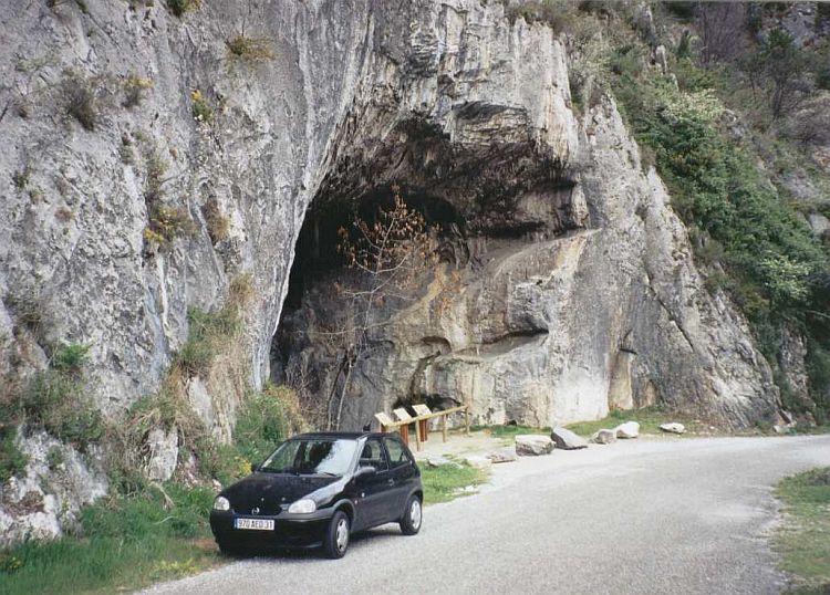
Grotte de la Petite Caougno submitted by thecaptain on 14th Feb 2005. The main entrance to the fabulous Niaux cave used for visitors is now further up the hillside than it once was. In ancient times, there would have been several lower, smaller entrances. This picture is of one of the small side entrances to a cave shelter in the vicinity, in which ancient remains have been found.
(View photo, vote or add a comment)
Log Text: Drive S through Pyrénées mountains to Andorra. Lots of snow at top of pass. Look at Ax-les-Thermes, Niaux and other caves on way back, investigating the possibility of a full visit to Niaux.
This is a small cave shelter beside the little road up to the modern Niaux entrance, in which ancient remains have been found.
I am sure I saw a bear wandering around in one of the fields below.
Grotte de Niaux
Trip No.200 Entry No.10 Date Added: 15th Jun 2020
Site Type: Cave or Rock Shelter
Country: France (Midi:Ariège (09))
Visited: Yes on 2nd Apr 2000. My rating: Access 4

Grotte de Niaux submitted by thecaptain on 14th Aug 2008. Bison inside the Grotte de Niaux.
(View photo, vote or add a comment)
Log Text: Grotte de Niaux near Tarascon in Ariège. Check out the world famous Niaux caves for a possible visit soon. The main entrance to the fabulous Niaux cave used for visitors is now further up the hillside than it once was. In ancient times, there would have been several lower, smaller entrances.
Brillaud Dolmen
Trip No.205 Entry No.72 Date Added: 15th Jun 2020
Site Type: Burial Chamber or Dolmen
Country: France (Midi:Ariège (09))
Visited: Yes on 10th Sep 2005. My rating: Condition 3 Ambience 4 Access 3
Brillaud dolmen submitted by theCaptain on 20th Dec 2010. First view of the dolmen. arriving from the east along a well maintained and signed footpath along a lovely ridgetop.
(View photo, vote or add a comment)
Log Text: At Cap-Del Pouech, I looked carefully at my maps and found that I could drive halfway to this dolmen and hopefully park up by La Page farm, which will save on the walking. From there, it was a 25 minute walk along a well maintained and signed footpath along a lovely ridgetop, but difficult underfoot on the bare and slippery limestone and mud.
It is in fact two dolmens, both within most of their stony mounds which are adjoined. The east dolmen has a chamber 3 metres by 1.5 metres, open towards the east, with two side slabs and a capstone still in place. The back stone has broken and fallen. The western dolmen is a bit of a wreck, and only faint remains of the chamber can be seen. The overall mound is about 20 metres in length, by 10 metres wide, and seems to have some large slabs in its perimeter, defining the outside shape.
On a good day, the views from up here would be superb, the high Pyrenees to the south, and the plain of Toulouse to the north, but today its just clouds. Good job I didnt try and get to the third (Couminges) dolmen on the walk, as its already 5:30 by the time I get back to the van !
Cap-Del Pouech Dolmen
Trip No.205 Entry No.71 Date Added: 15th Jun 2020
Site Type: Burial Chamber or Dolmen
Country: France (Midi:Ariège (09))
Visited: Yes on 10th Sep 2005. My rating: Condition 4 Ambience 4 Access 4

Cap-Del Pouech dolmen submitted by thecaptain on 13th Dec 2003. Cap-Del Pouech dolmen near Mas D'Azil, Ariege, southwest France.
I am not 100% sure whether this is the Cap del Pouech dolmen or another. I parked at the Southern entrance to the cave and followed a marked walking trail up and over the hill above the cave, following signs to the dolmen. There were other dolmens signposted in the area.
(View photo, vote or add a comment)
Log Text: Decided its silly to have come to Mas d'Azil and not gone to visit the dolmen, as it is signposted from the village, and you can drive up a narrow windy lane almost right to it, and theres a place to park just a few hundred metres from the dolmen.
It looks to me to have been re-erected at some point in the past, with one of its little supports possibly being concreted in. A large limestone capstone, 3.5 metres by 2.5 metres, sits high on top of 4 support stones, one backstone, one large and two smaller side stones. The chamber is 2.5 by 1.5 metres, and positioned on a little limestone outcrop with possibly some traces of a cairn around it.
Unfortunately, the poor thing has succumbed to the usual problems of graffitti and broken beer bottles. The dolmen de Brillaud is signposted from here, and I am tempted.....
Cap-Del Pouech Dolmen
Trip No.200 Entry No.2 Date Added: 15th Jun 2020
Site Type: Burial Chamber or Dolmen
Country: France (Midi:Ariège (09))
Visited: Yes on 27th Feb 2000. My rating: Condition 4 Ambience 4 Access 3
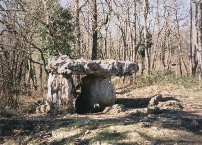
Cap-Del Pouech dolmen submitted by thecaptain on 13th Dec 2003. Cap-Del Pouech dolmen near Mas D'Azil, Ariege, southwest France.
I am not 100% sure whether this is the famed Cap del Pouech dolmen or another. I parked at the Southern entrance to the cave and followed a marked walking trail up and over the hill above the cave, following signs to the dolmen. There were other dolmens signposted in the area.
(View photo, vote or add a comment)
Log Text: Lovely walk to the dolmen from Mas D'Azil across the top of the cave. Signs suggest there are more here.
Grotte de Mas D'Azil
Trip No.200 Entry No.1 Date Added: 15th Jun 2020
Site Type: Cave or Rock Shelter
Country: France (Midi:Ariège (09))
Visited: Yes on 27th Feb 2000. My rating: Access 5

Grotte de Mas D'Azil submitted by thecaptain on 13th Dec 2003. The southern, upstream, entrance to the magnificent cave at Mas D'Azil, Ariege, southwest France.
The river takes a shortcut through the hillside here, and has created a massive cave, which is so big that a fairly large road also runs through the cave.
Within this cave were found signs of life going back tens of thousands of years, and indeed the world famous Faon aux Oiseaux spear thrower. The finds here gave the name Azilian to an entire prehistoric culture.
(View photo, vote or add a comment)
Log Text: Drive south into the lower mountains from Toulouse. Visit St Sulpice, Mas D’Azil, many mountain roads, Foix, Pont du Diable.
Grotte de Mas D'Azil
Trip No.205 Entry No.70 Date Added: 15th Jun 2020
Site Type: Cave or Rock Shelter
Country: France (Midi:Ariège (09))
Visited: Yes on 10th Sep 2005. My rating: Condition 4 Ambience 4 Access 5
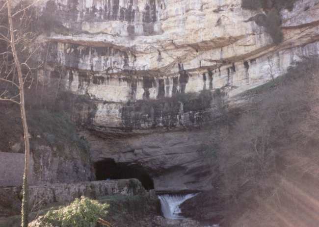
Grotte de Mas D'Azil submitted by thecaptain on 13th Dec 2003. The northern, downstream, exit of the Grotte de Mas D'Azil, Ariege, southwest France.
The river has taken a shortcut through the hill and has created a massive and magnificent cave. Artefacts found within this cave include the world famous Faon aux Oiseaux spear thrower, which along with other items has given the Azilian name to an entire prehistoric culture.
There are also several dolmens in the area.
(View photo, vote or add a comment)
Log Text: Parked at the upstream end of the Mas d'Azil cave, and it hits home again just how MASSIVE this cave is. I walk through the cave again, partly to check where the low bits are for the van. I have forgotten that you can see all sorts of bits and pieces of passages inside.
Decided not to bother with the paid visit, although perhaps I should have, cos I spent enough other time here anyway. A bungy jump has been set up outside the south entrance to the cave, and I watch people doing this for a while - seeing people dropping and hanging in front of the cave entrance really shows the scale. Eventually leave and drive through the cave to the village.
Source de Fontestorbes
Trip No.205 Entry No.78 Date Added: 15th Jun 2020
Site Type: Holy Well or Sacred Spring
Country: France (Midi:Ariège (09))
Visited: Yes on 11th Sep 2005. My rating: Condition 4 Ambience 4 Access 5
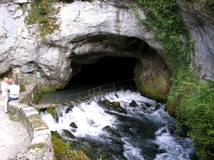
Source de Fontestorbes submitted by thecaptain on 28th Feb 2006. The intermittent Source de Fontestorbes in full flow.
(View photo, vote or add a comment)
Log Text: This is a very interesting place, one of only a few known examples in the world, with its intermittant spring gushing from a cave in a cliff face beside the road, well signposted a kilometre or so to the south of the little Pyrenean town of Belesta. In the dry summer months, due to a complex and not fully understood syphoning mechanism, the spring alternates between full flowing river, and barely a trickle, on an approximately hourly cycle for about 4 months of the year.
The place has been well done up since I was last here 5 years ago, with new parking area, a pedestrian bridge built over the stream, and a building with shop and cafe facilities, with more planned such as a picnic site and nature walk, and there were quite a lot of people here.
When I arrived, the spring was gushing quite a lot, the water easily covering the little steps across the entrance into the cave, just as it was every other time I have visited here in the past (I think I have been here about 4 times before, and never seen the spring dry up). So I went for a look round the little info centre, which now has a bar and lots of information about various tourist places and things, and was being run by a nice friendly couple, and it even has information leaflets about the spring in English these days. This explains the best understanding of the springs working, and states that it does not start cycling until after a long dry spell in the summer (I had always been in spring or early summer before).
As I left the centre, and had another look at the spring, it seemed to be slowing down. After another 5 minutes, the flow had lowered enough that a chap could walk across the steps and into the cave. Ten minutes later, it had slowed right down to a trickle, allowing people to walk across the stepping stones into the cave. It was not easy to see where the water comes from, it must be somewhere under the floor of the pond.
As would be expected of such a strange place, it has been revered since time immemorial, and of course there are many legends and stories associated with it. Excellent, I have at last seen this thing at work !
Beleven allée couverte
Trip No.209 Entry No.11 Date Added: 13th Jun 2020
Site Type: Passage Grave
Country: France (Bretagne:Côtes-D'Armor (22))
Visited: Yes on 12th Jun 2009. My rating: Condition 3 Ambience 2 Access 4

Beleven allée couverte submitted by thecaptain on 24th Jun 2009. There is even a sign here, but unfortunately while holding my camera above my head to get the picture, I have chopped off the bottom and left side a bit.
Still, it shows a plan and good artistic reconstruction of the place.
(View photo, vote or add a comment)
Log Text: Remains of a fairly disturbed but mostly complete allée couverte can be found in dark woodland to the northwest of the village of Plouer-sur-Rance, to the north of the magnificent ancient city of Dinan. Although the quartz block stones of this 14 metre long allée couverte are fairly well disturbed, it is in fact mostly complete, with a well defined terminal cella, and even with traces of its mound still to be seen. It is possible that it once had a lateral entrance.
Remarkably, it is stated that this monument was only discovered in 1972, which I find hard to believe, and it was classified as a monument historique as recently as 1981.
The poor thing is very close to a busy express highway, the N176, which runs along this northern edge of Brittany, but although the noise from the traffic is constant, the dense woodlands do a good job of hiding it all.
Despite looking on maps as if it would be very difficult to access, its on a wooded hillside right next to the dual carriageway road , there is in fact an emergency phone and layby nearby on the northbound carriageway, where it is possible to park and visit the monument. From the layby, hop over a little fence and follow a well worn path to the left for about 100 metres, and there it is ! Brilliant, its like the layby is deliberately put there for us stonehunters !
Outre Tombes
Trip No.209 Entry No.12 Date Added: 13th Jun 2020
Site Type: Stone Circle
Country: France (Bretagne:Ille-et-Vilaine (35))
Visited: Yes on 12th Jun 2009. My rating: Condition 3 Ambience 3 Access 5

Outre Tombes submitted by thecaptain on 5th Jul 2009. There are several information plaques at the site.
(View photo, vote or add a comment)
Log Text: This horseshoe of megalithic stones has alternatively been considered as a megalithic enclosure (cromlech) or perhaps the stones once surrounding a dolmenic burial chamber. Seven stones are shaped in a sort of semi circle, of diameter about 7 metres.
This monument was classified as a historical monument in 1966, but by 1977 had disappeared, being the victim of an expansion of the local quarry at Vaujour. When this was discovered, the police were called in, but it was all thought to be too late. However, in 1989 it was found that most of the stones hadn't simply been destroyed, but had been moved and dumped into a nearby field, although one had gone through the stonecrusher. With the help of a plan and photograph of the site taken in 1962, the local people (with the help of the quarrying company) had the site recreated in 1998, just a few hundred metres from its original position.
There is also a small menhir erected at the site, the origins of which I do not know, but the stone does not look modern. Today, the site sits in a little meadow near to the top of the quarry, and can be found beside the little road which runs along the top of the hills to the northeast of the massive Vaujour quarries. There are several information plaques at the site, telling of its history and with diagrams and pictures.
Menhir du Perron (St-Marcan)
Trip No.209 Entry No.14 Date Added: 13th Jun 2020
Site Type: Standing Stone (Menhir)
Country: France (Bretagne:Ille-et-Vilaine (35))
Visited: Yes on 12th Jun 2009. My rating: Condition -1
Log Text: A 2 metre tall menhir similar to the Roche Longue of St Marcan, once stood in the fields of Perron, about 800 metres south of La Roche Longue. It somehow disappeared in the 1930's.
St-Benoit polissoir
Trip No.210 Entry No.5 Date Added: 13th Jun 2020
Site Type: Polissoir
Country: France (Normandie:Manche (50))
Visited: Yes on 3rd Jun 2010. My rating: Condition 4 Ambience 4 Access 5
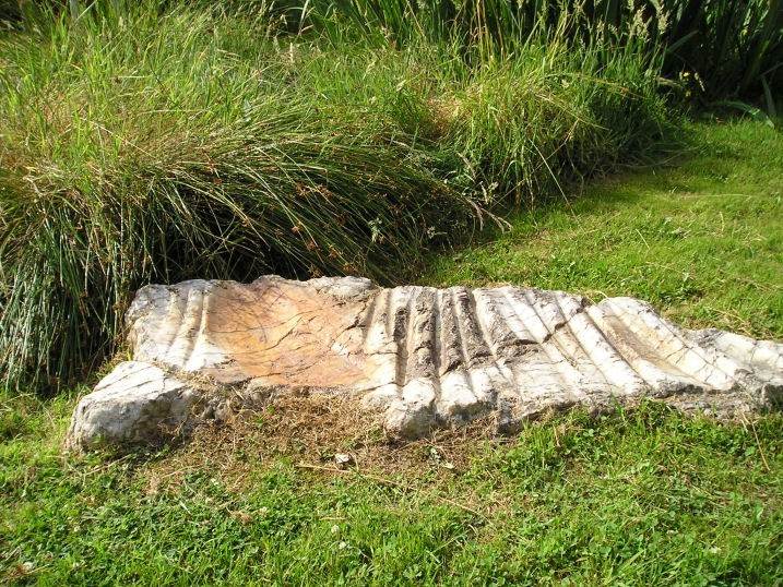
St-Benoit polissoir submitted by thecaptain on 14th Oct 2005. St Benoit polissoir, near St James.
Not a million miles from Mont St Michel, this lovely polissoir stone is nowadays nicely kept in a little garden type area beside the lane.
(View photo, vote or add a comment)
Log Text: Decide to take Dad here to see this special stone, so leave the autoroute at St James, to go have a look – the third time I will have tried to take Dad here, having missed it twice before due to roadworks and a shut bridge, and lateness on the previous occasions. Blimey, there are now big brown signs indicating it from the main road.
Set in its nice little marshy area, this is now very well looked after and presented, unlike the old description when I was first looking for it several years ago. The stone is a bit smaller than I remember it, but it is really wonderful. I just love being able to sit and stroke the very polished grooves, and let my mind wander back through the millennia. Again, Dad seemed well impressed at being able to see something like this.
St-Benoit polissoir
Trip No.203 Entry No.605 Date Added: 13th Jun 2020
Site Type: Polissoir
Country: France (Normandie:Manche (50))
Visited: Yes on 28th Jun 2005. My rating: Condition 4 Ambience 4 Access 5

St-Benoit polissoir submitted by thecaptain on 14th Oct 2005. St Benoit polissoir, near St James.
Not a million miles from Mont St Michel, this lovely polissoir stone is nowadays nicely kept in a little garden type area beside the lane.
(View photo, vote or add a comment)
Log Text: I was understanding that this polissoir stone was going to be difficult to find, but thought that I'd give it a go. Luckily for me, since the source of my information was written, it's all been tidied up into a nice little area and signposted. It's about 800m from the village of St Bénoit, up the D.363 to the east, beside the little stream.
The stone itself is a sort of white quartz, about 1.2 metres in length and flat on the ground. In the top face are three polishing bowls, one large, and up to 16 polishing grooves. The little stream which provides its water source to lubricate the polishing is rich in iron ore, and this has caused the stone to stain a rust red colour in its cracks and grooves.
The stone has been dated to 4000BC. Legends have become associated with such a stone, one being that it can cure colic in horses if they are walked around the stone three times, then made to drink the iron rich water within its basins.
Terriffic, I love these polissoir stones.
Mont St Michel
Trip No.203 Entry No.604 Date Added: 13th Jun 2020
Site Type: Ancient Village or Settlement
Country: France (Normandie:Manche (50))
Visited: Yes on 28th Jun 2005. My rating: Condition 5 Ambience 2 Access 4
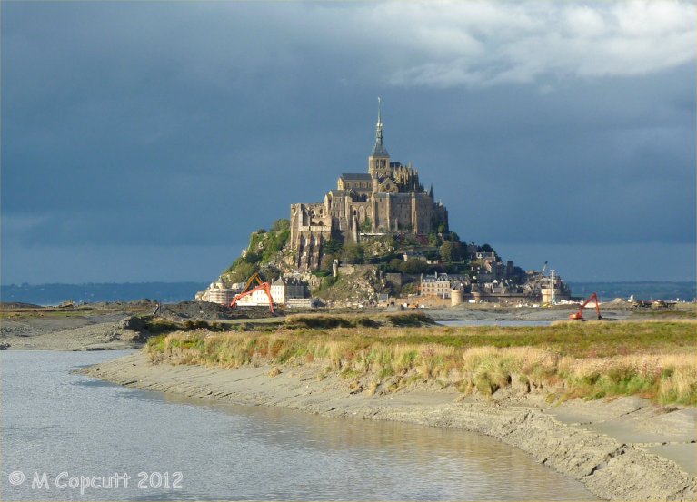
Mont St Michel submitted by theCaptain on 4th Jan 2013. They are trying to cut off the Mont again, to get the sea to surround it once more.
I read at the new controlling dam on the river that the land has risen 4.9 metres since the 1960s. Much of these new grassy marshes is being dug up and pushed into the river, hopefully to get washed away.
(View photo, vote or add a comment)
Log Text: Far too hot and busy and crowded.
Mont St Michel
Trip No.212 Entry No.13 Date Added: 13th Jun 2020
Site Type: Ancient Village or Settlement
Country: France (Normandie:Manche (50))
Visited: Yes on 11th Oct 2012. My rating: Condition 5 Ambience 4 Access 4
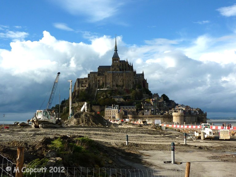
Mont St Michel submitted by theCaptain on 4th Jan 2013. They are trying to cut off the Mont again, to get the sea to surround it once more, and this involves removing the old causeway which prevented the tide clearing the silts etc, and just have a bridge going out to the Mont. This and alterations to the river should then mean the silts get washed away, and the sea once more claims the Mont at each high tide.
(View photo, vote or add a comment)
Log Text: Getting a late lunch at Plein Fougeres, it is now much too late to go to Fougeres and have a proper look round, so we decide to go to Mont St Michel for a quick look around. Shouldn't be too busy at this time of year. It has all changed since either myself or Dad was last there, and you now have to park miles away, at what is becoming a sort of holiday village resort. Many huge car parks, some hotels and restaurants etc, and a 40 min walk to the Mont, but free shuttle busses are provided. At this point I was ready to give up and drive away, but Dad still wanted to persevere, so we got the shuttle bus 10 mins out to the Mont.
Theres a hell of a lot of work going on here, both to the walls and the surroundings. Turns out they are trying to cut off the Mont again, to get the sea to surround it once more, and this involves removing the old causeway etc, and just have a sort of bridge going out to the Mont. This and alterations to the river should then mean the silts get washed away, and the sea once more claims the Mont at each high tide. I read at the new controlling dam on the river that the land has risen 4.9 metres since the 1960s. Much of these new grassy marshes is being dug up and pushed into the river, hopefully to get washed away.
The place is not too crowded, although many Japanese here, so we walk up to the abbey along the main street, no time to do the tour. Walk down around the outer walls, watching the tide coming in, and theres a group of people out walking over the sands and mud with the water coming in. Just as we leave the Mont, the sun starts to come out, making a few pictures much better.
Cup of tea, then on to Sara's, much later than we ought to be, but this time its not all my doing! Must visit here properly sometime, October Thursday mornings might be OK, but need the whole day.
La Roche Longue (St-Marcan)
Trip No.209 Entry No.13 Date Added: 13th Jun 2020
Site Type: Standing Stone (Menhir)
Country: France (Bretagne:Ille-et-Vilaine (35))
Visited: Yes on 12th Jun 2009. My rating: Condition 4 Ambience 3 Access 4

La Roche Longue (St-Marcan) submitted by thecaptain on 30th Jun 2009. View of La Roche Longue seen from the west.
(View photo, vote or add a comment)
Log Text: This well shaped menhir is just under 3 metres tall in a field to the east of the St Marcan cemetary. As with my previous visit, the field is planted with maize, and is today sodden wet, which prevents me from being abole to walk right up to the stone. However, this time I can walk up the western edge of the field by the cemetary, and photograph its other side in the afternoon sunshine.
