Contributory members are able to log private notes and comments about each site
Sites theCAptain has logged. View this log as a table or view the most recent logs from everyone
Arques Dolmen
Trip No.205 Entry No.165 Date Added: 24th Nov 2020
Site Type: Burial Chamber or Dolmen
Country: France (Languedoc:Gard (30))
Visited: Yes on 19th Sep 2005. My rating: Condition 3 Ambience 3 Access 4
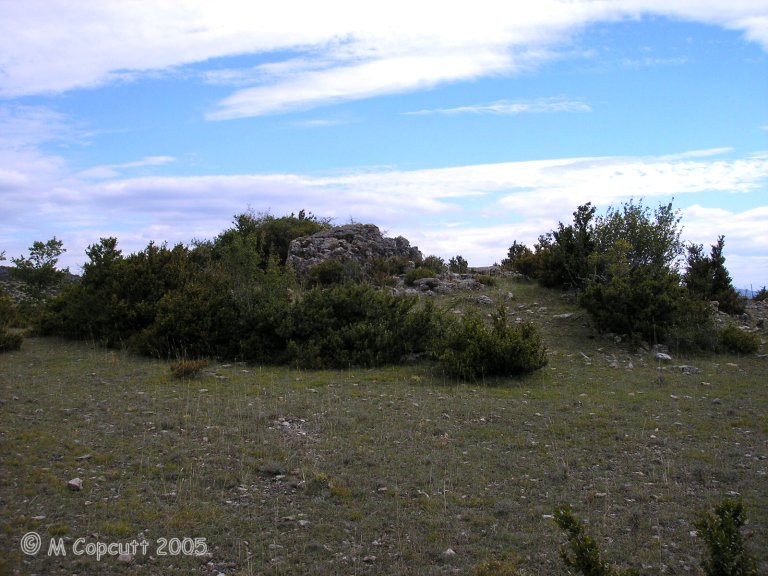
Arques Dolmen submitted by thecaptain on 9th Dec 2009. The remains of this fairly large dolmen are just off the road, and still mostly within a fairly large tumulus.
(View photo, vote or add a comment)
Log Text: This dolmen can be found just to the left of the road west from Planas towards Le Quintanel, turning left just before you reach Le Landre and continuing for about a kilometre until you pass the brow of a hill.
The remains of this fairly large dolmen are just off the road, and still mostly within a fairly large tumulus. The back stone and two side slabs are in position, but the capstone is dislodged to one side. The chamber is 3 metres long by 2.5 metres wide, and would probably have been large enough to stand in. There is the remains of a 7 metre long by 0.7 metre wide entry passage through the tumulus, which opens, as they all seem to do round here, towards the southwest, at 237°.
Serre de la Gleisa
Trip No.205 Entry No.158 Date Added: 15th Nov 2020
Site Type: Standing Stone (Menhir)
Country: France (Languedoc:Gard (30))
Visited: Saw from a distance on 19th Sep 2005. My rating: Condition 3 Ambience 3 Access 3
Serre de la Gleisa submitted by theCaptain on 12th Dec 2009. Serre de la Gleisa menhir is perhaps 100 metres from the road and well fenced in, so I couldnt get to it.
It looks about 2.5 metres tall, and slab shaped.
(View photo, vote or add a comment)
Log Text: Take the road towards Blandas from Montdardier, and after a few kilometres there is a big junction of ways. On the left, 100 metres or so before the junction, up the hill, can be seen this menhir, perhaps 100 metres from the road and well fenced in, so I couldn't get to it. It looks about 2.5 metres tall, and slab shaped.
Avernat menhir
Trip No.205 Entry No.167 Date Added: 24th Nov 2020
Site Type: Standing Stone (Menhir)
Country: France (Languedoc:Gard (30))
Visited: Yes on 19th Sep 2005. My rating: Condition 4 Ambience 3 Access 5

Avernat menhir submitted by thecaptain on 15th Dec 2009. The northern face of the menhir.
(View photo, vote or add a comment)
Log Text: This fine chap stands proudly at the junction of the roads D.158 and D.158a from Blandas to Le Landre and Quintanelles, just a couple of hundred metres from its neighbour, the menhir de Combes. It is very similar in both size and shape, 3 metres tall, except this one is not so superbly weathered. I am not sure whether it is in its original place here at the road junction or not.
Lacam de la Rigalderie
Trip No.205 Entry No.168 Date Added: 24th Nov 2020
Site Type: Stone Circle
Country: France (Languedoc:Gard (30))
Visited: Yes on 19th Sep 2005. My rating: Condition 5 Ambience 5 Access 4
Lacam de la Rigalderie submitted by theCaptain on 20th Dec 2009. The stones are mostly pillar shaped, but there are one or two triangles and pointy topped stones.
(View photo, vote or add a comment)
Log Text: Just to the south of the D.843 road between Blandas and Rigalderie, slightly to the west of what looks like a little airstrip, the remains of this lovely cromlech can be found on the slopes rising to a little hilltop. Unlike Lacam de Peyrarines, this one has a little parking area and a gated path to the cromlech, which is about 200 metres from the road across a field.
The circle is about 90 metres in diameter, and I counted 36 stones, either standing or fallen, with 20 or so properly standing upright. There are probably a few more stones in the lower part of the circle which is enveloped in bushes and undergrowth, where the circle seems to be embanked. Most of the stones are of the pale local limestone, but again as with Lacam de Peyrarines, one or two are of a brownish coloured stone. The height varies from half a metre to about 1.8 metres, except for a beautiful stone at the uppermost part of the circle which is about 2.5 metres in height, and a lovely shape.
The stones are mostly pillar shaped, but there are one or two triangles and pointy topped stones. The spacing is pretty even, at about 6 metres between stones, similar to Peyrarines. There is no evidence of a central pillar here.
Abri de la Salpetriere
Trip No.205 Entry No.197 Date Added: 26th Nov 2020
Site Type: Cave or Rock Shelter
Country: France (Languedoc:Gard (30))
Visited: Yes on 21st Sep 2005. My rating: Condition 2 Ambience 4 Access 4
Abri de la Salpetriere submitted by TheCaptain on 29th Jul 2020. Beside the river near to the Pont du Gard is a big cliff shelter, which was used as a dwelling in the age of reindeer.
(View photo, vote or add a comment)
Log Text: Beside the river near to the Pont du Gard is a big cliff shelter, which has a sign on it saying it was used as a dwelling in the age of reindeer. Excavations were going on within, and it was all fenced off.
Le Pont du Gard
Trip No.205 Entry No.198 Date Added: 26th Nov 2020
Site Type: Ancient Mine, Quarry or other Industry
Country: France (Languedoc:Gard (30))
Visited: Yes on 21st Sep 2005. My rating: Condition 5 Ambience 5 Access 5

Le Pont du Gard submitted by Humbucker on 25th Jul 2020. The Pont Du Gard in Provence on a beautiful May afternoon 2019
(View photo, vote or add a comment)
Log Text: Rive Gauche or Rive Droite? I went to the first one signed, Rive Droite. Probably better to have gone to the other side as that’s where all the information is. The Rive Droite side all got washed away in a storm on the 9th September 2002, when the river rose over 29 metres. They have pictures. Incredible.
What a lovely place. Fantastic bridge (used for over 500 years to supply water to the city of Nimes), lovely river and some splendid walks round signed footpaths which take you to various viewpoints and other bits of the ancient aqueduct system. Yes, you could spend ages here walking around, visiting the various museums etc (I didn't). Two and a half hours disappeared in no time and I was being quick. I'd best buy a book of pictures. Beautiful colours. Blue sky, golden bridge, green forested banks, shimmering green water and nearly white rocks.
Beautiful.
Planàs Dolmen
Trip No.205 Entry No.159 Date Added: 15th Nov 2020
Site Type: Burial Chamber or Dolmen
Country: France (Languedoc:Gard (30))
Visited: Yes on 19th Sep 2005. My rating: Condition 5 Ambience 3 Access 5
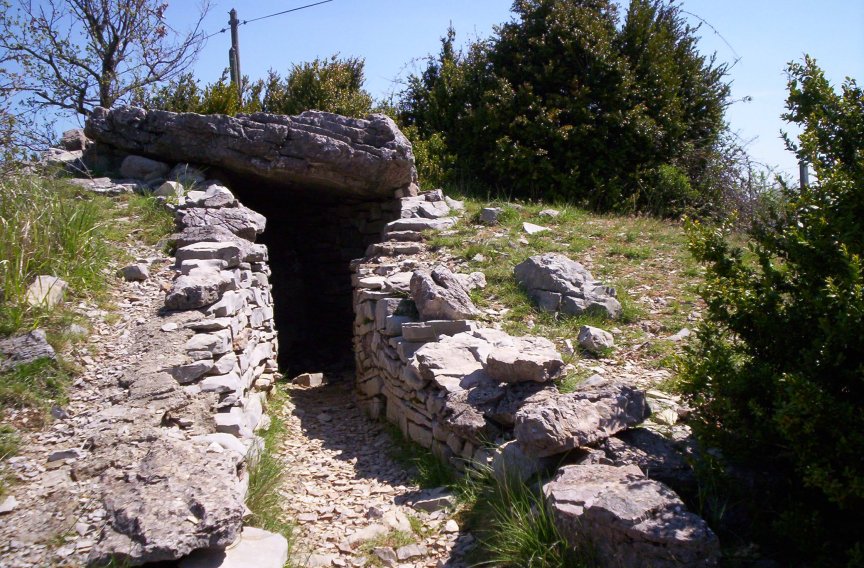
Planàs Dolmen submitted by regina on 11th Dec 2009. Site in Languedoc: Gard (30) France:
(View photo, vote or add a comment)
Log Text: Take the road towards Blandas from Montdardier, and after a few kilometres there is a big junction of ways. Right at the junction in a little enclosure to the right of the road can be found this nicely restored dolmen. It is completely within its cairn, and the fence is close, which makes photos difficult. The mound is about 12 metres in diameter and 2 metres high. The chamber in the centre is mostly made of dry stone walls, but with a large slab at the back, and topped by a 3 m by 2.5 m capstone, on top of the same sized chamber. There is an entry passageway about 5 metres long, and half a metre wide, which opens to the southwest at 235°.
Planàs cromlech
Trip No.205 Entry No.161 Date Added: 15th Nov 2020
Site Type: Stone Circle
Country: France (Languedoc:Gard (30))
Visited: Yes on 19th Sep 2005. My rating: Condition 1 Access 5
Planàs cromlech submitted by LaDragonne on 23rd Aug 2018. Cromlech de Planas:Gard (30) France
une des pierres couchée à quelques dizaines de cm de son lieu d'implantation
(View photo, vote or add a comment)
Log Text: Destroyed many years ago during construction of the road, just a few stumps and fallen stones of this cromlech remain scattered around near the junction. What was once a fine stone circle is now just a large road junction in the middle of nowhere.
Menhir de Landre 2
Trip No.205 Entry No.164 Date Added: 24th Nov 2020
Site Type: Standing Stone (Menhir)
Country: France (Languedoc:Gard (30))
Visited: Saw from a distance on 19th Sep 2005
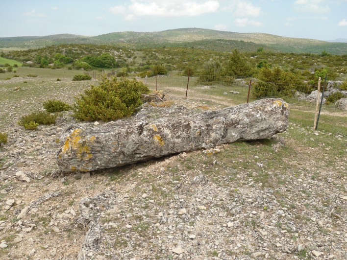
Menhir de Landre 2 submitted by regina on 22nd Jun 2011. Site in Languedoc:Gard (30) France
Menhir de Landre 2
(View photo, vote or add a comment)
Log Text: About 100 metres to the south of Landre menhir 1, atop the adjacent hillock can be found this fallen menhir. As for menhir 1, this was too well fenced in, and I didn't get to visit it.
Flouirac Dolmen
Trip No.205 Entry No.171 Date Added: 24th Nov 2020
Site Type: Burial Chamber or Dolmen
Country: France (Languedoc:Gard (30))
Visited: Couldn't find on 19th Sep 2005
Flouirac dolmen submitted by ocdolmen on 9th Apr 2006. Flouirac dolmen, also known as Ostalet de la Fada
(View photo, vote or add a comment)
Log Text: This dolmen is supposedly about 1.5 kilometres to the east of the hamlet of Barral, and just 25 metres to the nmorth of the road. However, it is so well hidden , that even after exensive searching, I could find no traces of it.
Mas Neuf menhir
Trip No.205 Entry No.193 Date Added: 26th Nov 2020
Site Type: Standing Stone (Menhir)
Country: France (Languedoc:Gard (30))
Visited: Couldn't find on 21st Sep 2005
Log Text: I had a good look around for this menhir, but couldn't find anything.
Colline de Moulin Menhir
Trip No.205 Entry No.194 Date Added: 26th Nov 2020
Site Type: Standing Stone (Menhir)
Country: France (Languedoc:Gard (30))
Visited: Yes on 21st Sep 2005. My rating: Condition 2 Ambience 3 Access 4

Colline de Moulin menhir submitted by regina on 13th Dec 2009. Colline de Moulin menhir in Gard (30) France
(View photo, vote or add a comment)
Log Text: From the cemetary to the south of Aubais, walk southwest up the little track to the ancient windmill, and after about 800 metres you arrive at the top of this windy little hill. Here, about 50 metres from the old windmill, has been re-erected the menhir, mended from several parts and mounted on a little plinth. It is only about 1.5 metres high, but has several legends associated with it. There are three circular cupules to be seen in the southern face.
Pierre Plantée (Congénies)
Trip No.205 Entry No.195 Date Added: 26th Nov 2020
Site Type: Standing Stone (Menhir)
Country: France (Languedoc:Gard (30))
Visited: Yes on 21st Sep 2005. My rating: Condition 4 Ambience 3 Access 4
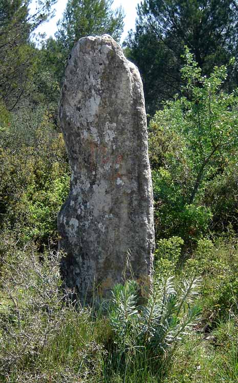
Pierre Plantée (Congénies) submitted by Nick- on 26th Apr 2007. 18/04/2007 Western face of the stone.
(View photo, vote or add a comment)
Log Text: Drive north from Aubais towards Congénies for about 1.5 km, and at the bend in the road there is a stoney track which heads off to the east. Take this track along the ridge for about 400 metres, and at a major junction of tracks, on the left, can be seen this menhir.
The stone is about 2.3 metres tall, 1.5 m wide at the base and 40cm thick, standing in amongst some very prickly undergrowth. On both faces are several carvings and engravings, from ancient to more modern graffitti. Amongst the ancient are several cupules and some crosses. There are also symbols which resemble letters or Greek symbols. A little offering of flowers had been placed into a crack in the stone when I visited, so obviously somebody still cares for this ancient stone.
Menhir le Bâton de Samson
Trip No.205 Entry No.211 Date Added: 30th Nov 2020
Site Type: Standing Stone (Menhir)
Country: France (Languedoc:Gard (30))
Visited: Yes on 24th Sep 2005. My rating: Condition 4 Ambience 3 Access 4

Menhir le Bâton de Samson submitted by ocdolmen on 3rd Aug 2009. Jouffre menhir (3.60 metres) called "Bâton de Samson" (Samson's stick)
(View photo, vote or add a comment)
Log Text: From the village of Ambruze, take the D.133 towards St Felix-de-Pailleres. After a kilometre or two up the hill, there is a turning to the left to Le Jouffre and Lotissement de Menhir. A couple of hundred metres down here, taking first the lower, left, road, then to the right, there is a little wooded area with a pathway entering. The menhir is in here, and about 4 metres tall, of a squarish cross section. It has some nice weathering on one of its sides, all full of holes.
Dolmen de Saint-Pierre 1
Trip No.205 Entry No.212 Date Added: 30th Nov 2020
Site Type: Burial Chamber or Dolmen
Country: France (Languedoc:Gard (30))
Visited: Couldn't find on 24th Sep 2005. My rating: Access 3
Dolmen de Saint-Pierre 1 submitted by ocdolmen on 29th Aug 2006. Dolmen de Saint-Pierre 1
This small megalithic monument is located on the footpath and has suffered a lot.
Length about 1.80 meter.
(View photo, vote or add a comment)
Log Text: From the Col de St Pierre, several kilometres to the north of St Jean du Gard along the Corniche des Cevennes, take the PR11 footpath towards the summit of Roc St Pierre, and the orientation table. Along this path should be findable two dolmens. However, I walked all the way up the hill to the viewpoint, but found no dolmens. There are however, tremendous 360° views from the top though, and it is well worth the effort.
Saint-Pierre dolmen 2
Trip No.205 Entry No.213 Date Added: 30th Nov 2020
Site Type: Burial Chamber or Dolmen
Country: France (Languedoc:Gard (30))
Visited: Couldn't find on 24th Sep 2005. My rating: Access 3
Dolmen de Saint-Pierre 2 submitted by ocdolmen on 29th Aug 2006. Dolmen de Saint-Pierre 2
This dolmen is located at forty meters from the dolmen1. It is preserved better.
Built like dolmen 1 with schist flagstones taken on the spot, it is approximately 2 meters long.
(View photo, vote or add a comment)
Log Text: From the Col de St Pierre, several kilometres to the north of St Jean du Gard along the Corniche des Cevennes, take the PR11 footpath towards the summit of Roc St Pierre, and the orientation table. Along this path should be findable two dolmens. However, I walked all the way up the hill to the viewpoint, but found no dolmens. There are however, tremendous 360° views from the top though, and it is well worth the effort.
Rougeiresque menhir
Trip No.205 Entry No.214 Date Added: 30th Nov 2020
Site Type: Standing Stone (Menhir)
Country: France (Languedoc:Gard (30))
Visited: Yes on 24th Sep 2005. My rating: Condition 4 Ambience 4 Access 4
Rougeiresque menhir submitted by heather-connie on 21st Apr 2007. Category A
Lizard Stone - A cup-marked stone set high on the ridge between the Vallée Française and the Vallée Borgne. A beautiful piece of quartz-layered schist. It is near the village of Saint André de Valborgne. I call it the Lizard Stone as on my first visit a hugh emerald green lizard was sheltering at its base.
Location Lat. 44.166 Lon. 3.703
(View photo, vote or add a comment)
Log Text: Travelling along the Corniche-des-Cévennes, stop at the point where the road from Gabriac joins from the north east. Just about opposite to this junction can be found a track up the other side of the road, signposted to the Schistes Cévenolles quarries. Walk up this track for about 500 metres, and just after the track splits at the top of the ridge, this nice menhir can be seen 50 metres in front of you, re-erected in a little stone and cement base.
The menhir is about 3.5 metres tall, made of a nice piece of schist with a quartz vein through the middle. On the south facing side there are many cupules (I counted 15), while on the back face I counted 6. Some of these are quite large, and they mostly form a row up the right hand side of the stone as you look at it for both faces.
Morrel das Fadas
Trip No.200 Entry No.62 Date Added: 18th Jun 2020
Site Type: Passage Grave
Country: France (Languedoc:Aude (11))
Visited: Yes on 13th Aug 2000. My rating: Condition 4 Ambience 5 Access 4
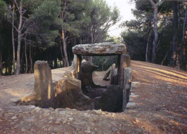
Morrel das Fadas submitted by thecaptain on 6th Dec 2003. The Dolmen des Fades, near to the village of Pepieux, in the Minervois region of Aude, southwest France
(View photo, vote or add a comment)
Log Text: Day out from Toulouse to explore Minerve ancient village, Rock tunnels, Morrel das Fadas, St Eugene. On a little hill covered in pines to the south of the D52 road to the northeast of Carcassonne is found the remains of this teriffic allée couverte, the hill of the fairies, said to be the largest in southern France.
Allée Couverte de Saint-Eugène
Trip No.205 Entry No.103 Date Added: 9th Nov 2020
Site Type: Passage Grave
Country: France (Languedoc:Aude (11))
Visited: Yes on 14th Sep 2005. My rating: Condition 4 Ambience 4 Access 4

Allée Couverte de Saint-Eugène submitted by thecaptain on 6th Dec 2003. This is what I think is described as les Allees Couvertes de Saint- Eugene, .
However, it was getting late and the roads and map didnt seem to match. I just followed signs to something like fairy hill, and on top of a hill was this amazing site, with a circular walled structure with various chambers and passages in it.
(View photo, vote or add a comment)
Log Text: I have now twice found this only by luck. This time I took a wrong turning (one road too soon) and ended up on a stone track across private land where I could not turn round to go back out, and then I saw a little sign to dolmen, up the hillside I remember. I managed to park the van in a wider part of the track about 500 metres away, and went back on foot to look for the site. Quite how one is meant to get here properly, I do not know !
Up on top of a pine covered hill is an open flattish area, upon which is built this lovely tomb. It has all been much restored, so quite how much is original I do not know. The first thing you see is a circular stone wall containing a stone cairn, about a metre high and about 25 metres in diameter, with upright slabs every 5 metres or so around its circumference. Within this is the remains of a massive structure, and a partitioned chamber. The main chamber is 15 metres long, lined with large slabs, and opens to the southeast at 155°. At the back end it is 4 metres wide, and 5.5 m from the end is the remnants of a stone partition within which the remains of portal entranceway can be seen. The next section is 6 metres long, tapering to 2.5 metres wide, up to the remains of another partition with entranceway. This leaves just 3 metres of tapering corridor to the entrance in the circular wall, just 1 metre in width. Unfortunately there are no cover stones, and the entrance portals are very damaged, to the extent of being almost non existant. In the stone mound there can be seen the remains of two further intermediate circling walls, the first a U shape around the chamber, and the second a concentric circle within the outside wall.
Carcassonne - La Cité
Date Added: 17th Jun 2020
Site Type: Ancient Village or Settlement
Country: France (Languedoc:Aude (11))
Visited: Yes on 15th Sep 1978
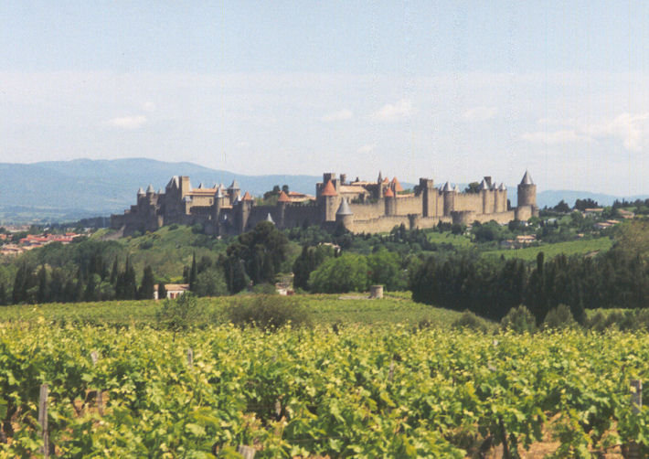
Carcassonne - La Cité submitted by thecaptain on 19th Feb 2005. La Cité de Carcassonne, seen here from the south.
Ancient citadel which goes back as far as time. Although the main remains of this fantastic fairy story city are now mediaeval much of the walls can be seen to date back to Visigoth and Roman times. This is of course, all built upon a citadel which was here long before any of them came here.
(View photo, vote or add a comment)
Log Text: Ancient citadel which goes back as far as time. Although the main remains of this fantastic fairy story city are now medieval much of the walls can be seen to date back to Visigoth and Roman times. This is of course, all built upon a citadel which was here long before any of them came here.
