Contributory members are able to log private notes and comments about each site
Sites theCaptain has logged on trip number: 202 (View all trips)
View this log as a table or view the most recent logs from everyone
Dolmen de la Ferme Brûlée
Trip No.202 Entry No.82 Date Added: 30th Mar 2020
Site Type: Burial Chamber or Dolmen
Country: France (Centre:Eure-et-Loire (28))
Visited: Yes on 3rd May 2005

Dolmen de la Ferme Brûlée submitted by thecaptain on 10th Nov 2005. La Ferme Brûlée dolmen.
Just to the south of Fort Harrouard neolithic settlement, on the banks of the river Eure, is another of these dolmens inside a private garden with lots of keep out signs and security fences. However, it can be seen over the gate, down at the end of the driveway.
(View photo, vote or add a comment)
Log Text: Down by the banks of the river Eure are marked on my map a dolmen and polissoir. I couldn’t park close so parked and walked back from some distance away during which time I got soaked by a torrential downpour. I eventually found a house called Le Dolmen but with lots of keep out signs and security devices. Down the far end of the driveway I could see the dolmen and managed a long distance photo of it part hidden by a van. There was no way I could get any sight of the polissoir which was a shame.
Fort Harrouard
Trip No.202 Entry No.84 Date Added: 30th Mar 2020
Site Type: Ancient Village or Settlement
Country: France (Centre:Eure-et-Loire (28))
Visited: Saw from a distance on 3rd May 2005
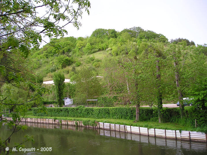
Fort Harrouard submitted by thecaptain on 10th Nov 2005. Fort Harrouard seen above the river Eure.
(View photo, vote or add a comment)
Log Text: This ancient defended settlement is positioned on a steep hillside high above the river Eure near the village of Marcilly-sur-Eure.
Vielle Cote Dolmen
Trip No.202 Entry No.95 Date Added: 30th Mar 2020
Site Type: Passage Grave
Country: France (Ile-de-France:Val-d'Oise (95))
Visited: Yes on 4th May 2005. My rating: Condition 2 Ambience 3 Access 3

Vielle Cote Dolmen submitted by thecaptain on 23rd Oct 2005. Vielle Cote Dolmen
A much ruined trench grave about 10 metres in length.
(View photo, vote or add a comment)
Log Text: A much ruined trench grave about 10 metres long and 2 metres wide with an orientation of 292° looking down the hill can be found dug into the hillside in a field of crops along a lane at the top of a ridge about 400 metres south from the little lane which climbs eastwards from the village. Although marked on my ign map there are no signs or any other items to suggest its presence. Parking is available at the junction of the lane and track.
Menhir des Demoiselles (Colombiers-sur-Seulles)
Trip No.202 Entry No.1 Date Added: 25th Mar 2020
Site Type: Standing Stone (Menhir)
Country: France (Normandie:Calvados (14))
Visited: Yes on 23rd Apr 2005. My rating: Condition 3 Ambience 3 Access 5
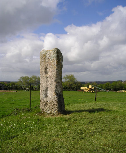
Menhir des Demoiselles (Colombiers-sur-Seulles) submitted by thecaptain on 28th Apr 2005. Just over 2 metres in height, this menhir is set in its own little grassy area beside the road junction just uphill to the east of the village. It is a square pillar with several holes and indentations, and has been broken in the past at both top and bottom (probably during the war) and is now remounted on a concrete post. While I was here it was sunny between the clouds, there was a bike race going on past the stone, and an old warplane flying above, which all added to a nice French rural scen...
(View photo, vote or add a comment)
Log Text: Just over 2 metres in height this menhir is set in its own little grassy area beside the road junction just uphill to the east of the village. It is a square pillar with several holes and indentations and has been broken in the past at both top and bottom (probably during the war) and is now remounted on a concrete post.
While I was here it was sunny between the clouds there was a bike race going on past the stone and an old warplane flying above which all added to a nice French rural scene
La Pierre Cornue
Trip No.202 Entry No.11 Date Added: 25th Mar 2020
Site Type: Standing Stone (Menhir)
Country: France (Normandie:Calvados (14))
Visited: Yes on 23rd Apr 2005. My rating: Condition 4 Ambience 3 Access 5

La Pierre Cornue submitted by TheCaptain on 6th May 2005. La Pierre Cornue, a more than 4 metres tall menhir.
(View photo, vote or add a comment)
Log Text: A very large menhir in disturbed ground which looks to be an old stone quarry just behind the Mairie which is just to the west of the main street a few hundred metres south of the church. The menhir is made of a strange sort of stony conglomerate and is a strange shape and contains many holes. It is more than 4 metres high 2.5 metres wide and over a metre thick at the base although the main part of the stone is about half a metre thick.
La Hogue
Trip No.202 Entry No.6 Date Added: 25th Mar 2020
Site Type: Chambered Tomb
Country: France (Normandie:Calvados (14))
Visited: Saw from a distance on 23rd Apr 2005
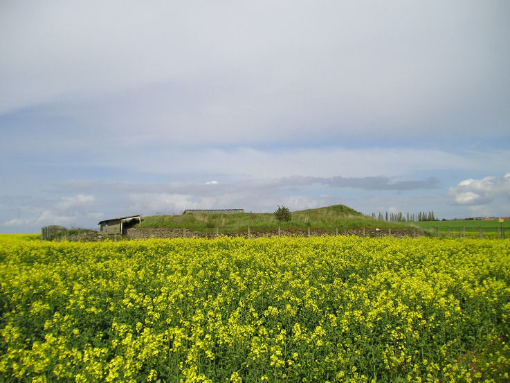
La Hogue submitted by TheCaptain on 6th May 2005. La Hogue Tumulus, Fontenay-le Marmion, Calvados
The excavated remains of this large round barrow with 12 internal burial chambers is fenced off within a field of rapeseed. What was once a guardian with a key to the site in the nearby house was today a lady who told me that “Il est fermée monsieur”.
(View photo, vote or add a comment)
Log Text: Despite being signed from the main road and having a Bar le Tumulus nearby the excavated remains of this large round barrow with 12 internal burial chambers is fenced off within a field of rapeseed. What was once a guardian with a key to the site in the nearby house was today a lady who told me that “Il est fermée monsieur”.
La Hoguette
Trip No.202 Entry No.7 Date Added: 25th Mar 2020
Site Type: Chambered Tomb
Country: France (Normandie:Calvados (14))
Visited: Yes on 23rd Apr 2005. My rating: Condition 1 Ambience 1 Access 5

La Hoguette submitted by TheCaptain on 6th May 2005. La Hoguette Tumulus, Fontenay-le Marmion, Calvados.
Despite all my records stating that this large round tumulus with 8 passage graves no longer exists, the remains are quite easy to find within the village. It remains today as a green grassy area within a housing estate, surrounded by roads called something like Rue la Tumulus and Rue La Hoguette. There is a large diameter mound with a slight hollow in the middle, and remains of some form of signpost.
(View photo, vote or add a comment)
Log Text: Despite all records stating that this large round tumulus with 8 passage graves is no longer there the remains are quite easy to find within the village. It remains today as a green grassy area within a housing estate surrounded by roads called something like Rue la Tumulus and Rue La Hoguette. There is a large diameter mound with a slight hollow in the middle and remains of some form of signpost.
Pierre Tourneresse, Cairon
Trip No.202 Entry No.5 Date Added: 25th Mar 2020
Site Type: Chambered Tomb
Country: France (Normandie:Calvados (14))
Visited: Yes on 23rd Apr 2005. My rating: Condition 4 Ambience 4 Access 4
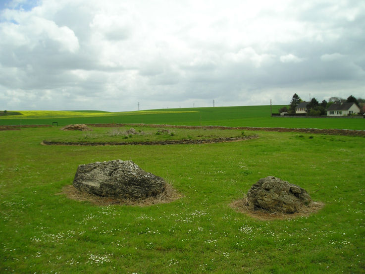
Pierre Tourneresse, Cairon submitted by thecaptain on 28th Apr 2005. Pierre Tourneresse, Cairon. Seen here looking towards the remains of the large round burial mound from beyond the two large stones which are the remains of the capstone from the main chamber - removed and destroyed by the Germans during the '39-45 war.
(View photo, vote or add a comment)
Log Text: I wasn’t expecting to find much here if anything at all as all the information I had of this site was a menhir symbol on my ign map. But as I was passing I decided to have a look anyway and luckily stopped to look at my map right by a little road at the east of the southern end of the village with a sign to “Pierre Tourneresse”. So I followed it down to the end of a little modern housing estate and parked. A further signpost at the end of the road points to Pierre Tourneresse 300 metres distant. Turn left here and stick to the back of the houses rather than go straight on up the hill.
What a lovely site this is. In a little dip down near the stream is a newly made and signposted enclosure which at the time of my visit was still under construction with a ring of trees being planted well around the outside of it. Inside the enclosure is the remains of a large approximately round cairn which has a diameter of about 19 metres and is edged all around with dry stone walling within which are two chambers.
The main chamber is large stone lined chamber in approximately the middle of the cairn which has a seven metre long entrance passage which exits to the east of the cairn at a bearing of 100° magnetic. The chamber is approximately rectangular dimensions about 4 to 5 metres in length by 3 metres in width and is made with large upright slabs with drystone walling between. At various positions around this large chamber there seem to be smaller alcoves or features. The second much smaller chamber opens to the west side and is positioned approximately opposite to the main chamber entrance with an alignment of 269°. It is about 3.5 metres long and opens up to about 2 metres in width at its maximum. It is made with drystone walling only and has a ledge of some sort along its northern side.
Outside the cairn at a distance of about 15 metres in a northwesterly direction are two very large stones. I wondered whether these were once menhirs which marked the position of the cairn (these northern French cairns are often associated with menhirs) and which would explain the marking of menhir on the ign maps. Looking at these stones more closely however suggested that it is much too wide to have been a menhir so I wondered whether the stones were the remains of the chamber capstone. I spent quite a lot of time here the place seemed to give off a nice happy atmosphere which was probably helped by the fact that for once one of these much neglected ancient Normandy monuments is being lovingly cared for and looked after what was probably many years of neglect.
As I was leaving I met a man walking his dog and asked if he knew anything about the site. By an amazing stroke of luck I had met one of the few people in France who has an interest in these ancient sites and who collects flint artefacts ! Despite the language problems we talked for about half an hour about things. He told me that the cairn had been much more complete up until the war during which the Germans had used it as a shelter and gun emplacement. As they were leaving after the D-Day invasion they went about destroying it and the two large stones are indeed the remains of the capstone to the main chamber. He also told me that an excavation of the site was done 5 years ago and the restoration has been going on since then.
We got on to discussing other sites in the region and other than the various sites I knew about (he was surprised indeed to find an Englishman who knew anything about any of these places and seemed very interested when I told him I intended to write a book) and he told me of a menhir nearby he knew which was destroyed only a couple of years ago by a farmer who didn’t want it in the middle of one of his fields. He also showed me on my map a couple of places where he goes to find flint items one of which he called a quarry. He said that if I went to one of these places he showed me then if the fields were recently ploughed I would almost certainly find some worked flint items and that he had a collection of over 700 items. He also then told me in detail how to find the two polisher stones near Mont Joly which was of great interest as I would probably not have even looked if I had no detailed information to go on. It was very nice to meet a man like this particularly on my first real day of French stonehunting and it made me think that the whole trip is going to go well.
Bons Tassilly polissoirs
Trip No.202 Entry No.14 Date Added: 26th Mar 2020
Site Type: Polissoir
Country: France (Normandie:Calvados (14))
Visited: Yes on 23rd Apr 2005. My rating: Condition 3 Ambience 5 Access 4

Bons Tassilly polissoirs submitted by TheCaptain on 6th May 2005. Mont Joly polissoirs, Bons Tassilly, Calvados.
The first of two polissoirs beside the river which forms the gorge surrounding the Mont Joly promontory site.
On the top surface of this stone are two large polished bowl areas, and three grooves, made by polishing the hard stone into tools.
(View photo, vote or add a comment)
Log Text: Two polissoirs can be found beside the river which forms the gorge surrounding the Mont Joly promontory site. Follow signs to the Brèche de Diable park the car and then walk along the footpath which follows the river up this splendid rocky gorge. After several hundred metres the path diverges from the river and starts uphill to the left when you come to a fenced area. At this point go down towards the stream and the two polissoir stones can be found one on each side of the river.
The first one on the near side of the river is a block of hard stone sticking out of the hillside about 2 metres long and a metre wide. On the top surface of this stone are two large polished bowl areas and three grooves made by polishing the hard stone into tools. It is wonderful to sit down on one of the ends of this stone and imagine polishing away to make an axe or similar. In fact I was very tempted to just sit there and make one !
The polissoir on the far side of the stream has now been fenced off within private ground and cannot be reached although can clearly be seen.
Mont Joly
Trip No.202 Entry No.13 Date Added: 26th Mar 2020
Site Type: Ancient Village or Settlement
Country: France (Normandie:Calvados (14))
Visited: Yes on 23rd Apr 2005. My rating: Condition 2 Ambience 4 Access 5

Mont Joly submitted by TheCaptain on 7th May 2005. Mont Joly, Soumont-Saint-Quentin, Calvados.
This is a promontory site surrounded on three sides by the steep gorge of the river Laizon. The site has been inhabited and defended since Paleolithic times, and artefacts have been found from all times since this. It is said that although little ancient remains can be seen, they are everywhere underfoot, and every molehill will contain several flints and pottery sherds.
(View photo, vote or add a comment)
Log Text: This is a promontory site surrounded on three sides by the steep gorge of the river Laizon and the eastern end has been defended by ramparts little of which can now be seen between the church and water tower. The site has been inhabited and defended since Paleolithic times and artefacts have been found from all times since this. It is said that although little ancient remains can be seen they are everywhere underfoot and every molehill will contain several flints and pottery sherds. This region was a major supplier of flint tools in the past and there is much to be found here.
Colombiers-sur-Seulles tumulus
Trip No.202 Entry No.2 Date Added: 25th Mar 2020
Site Type: Chambered Tomb
Country: France (Normandie:Calvados (14))
Visited: Yes on 23rd Apr 2005. My rating: Condition 4 Ambience 4 Access 5
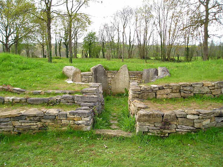
Colombiers-sur-Seulles tumulus submitted by TheCaptain on 7th May 2005. Colombiers-sur-Seulles tumulus, Calvados.
The circular burial chamber in the northern side of the mound.
(View photo, vote or add a comment)
Log Text: A long barrow which has been excavated and destroyed several times in the past but which has recently been restored to some form of its former glory by local enthusiasts. It is situated about half a kilometre east of the village just beyond the menhir signposted in a little copsed area just south of the road.
The barrow is about 50 metres in length and about 9 metres in width at the narrow west end and 18 metres width at the wide eastern end with an orientation of 280°. It is about 5 metres in height at its maximum and has several drystone walled sections running around it. In the middle of the mound is a little circular burial chamber about 2.5 metres in diameter with its entrance chamber running from the north side at an orientation of 010°. The chamber is made using 6 large upright stones with drystone walling between them but how much is now original is not known. The view along the entrance chamber does not see over the local horizon which is just a hundred metres or so distant. At the smaller western end there is a pair of large upright stones set into the external wall and as far as I can find once formed the entrance to another smaller burial chamber.
This is obviously now a well looked after and cared for monument set within a fenced off area using rustic fencing and also within the area are a mock up of an ancient oven and some hearths. with drystone walling between them but how much is now original is not known.
Bretteville-le-Rabet
Trip No.202 Entry No.9 Date Added: 25th Mar 2020
Site Type: Ancient Mine, Quarry or other Industry
Country: France (Normandie:Calvados (14))
Visited: Yes on 23rd Apr 2005. My rating: Condition 2 Ambience 2 Access 5

Bretteville-le-Rabet submitted by TheCaptain on 8th May 2005. Bretteville-le-Rabet flint quarries, Calvados.
I spent just 5 minutes looking around the edge of this freshly ploughed field and found four bits of worked flint, including a nice scraper tool.
(View photo, vote or add a comment)
Log Text: Not marked on any map I was told of this place by a man who collects flint artefacts I met at Cairon so I went for a quick look. Nothing much to see but the fields here were freshly ploughed and within 5 minutes of looking along the edges of the fields by the roadside I had found 4 worked flint artefacts.
Menhir dit Pierre Debout (Reviers)
Trip No.202 Entry No.3 Date Added: 25th Mar 2020
Site Type: Standing Stone (Menhir)
Country: France (Normandie:Calvados (14))
Visited: Couldn't find on 29th Dec 2005
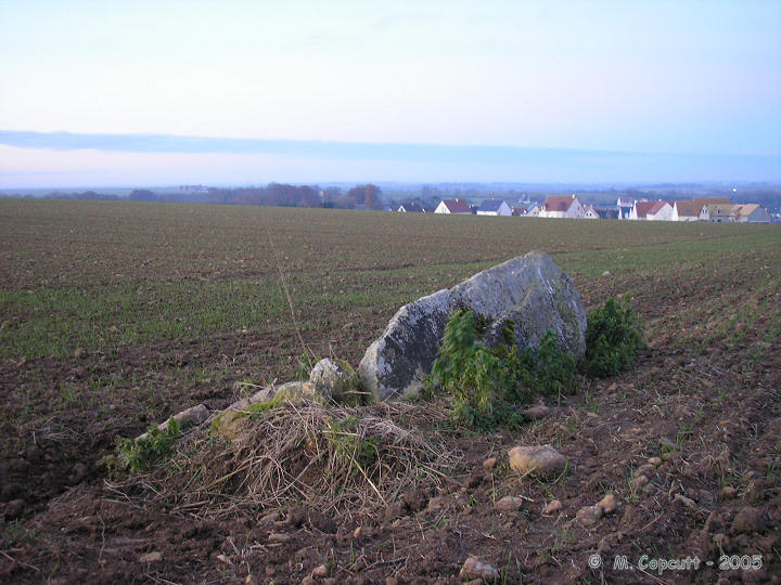
Menhir dit Pierre Debout (Reviers) submitted by thecaptain on 29th Dec 2005. Reviers menhir.
Just inland from the D-Day beaches can be found (when the crops are down) the sad remains of this menhir.
(View photo, vote or add a comment)
Log Text: Despite being marked on the ign map and having a good look all around I could find no sign of any menhir here. Perhaps it is fallen and somewhere within a field of oilseed Rape.
Later note. Having seen the 1:25000 ign map of the area the menhir is marked fairly close to the corner of the road and farm track right where I was looking originally. As I suspected the menhir must be fallen and hidden within the crop.
La Butte du Hu
Trip No.202 Entry No.10 Date Added: 25th Mar 2020
Site Type: Chambered Cairn
Country: France (Normandie:Calvados (14))
Visited: Saw from a distance on 23rd Apr 2005
La Butte du Hu submitted by thecaptain on 8th Oct 2006. Plan of La Butte du Hu, Ernes, as shown on the sign at Colombiers-sur-Seulles.
(View photo, vote or add a comment)
Log Text: North of the village of Ernes several hundred metres up a farm track from the hamlet of Vey d’Ifs on the top of the ridge this large chambered tumulus can be seen just within a field growing crops so I did not enter.
Langrais menhirs
Trip No.202 Entry No.12 Date Added: 26th Mar 2020
Site Type: Standing Stones
Country: France (Normandie:Calvados (14))
Visited: Saw from a distance on 23rd Apr 2005
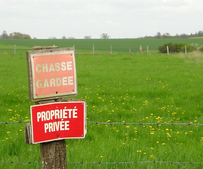
Langrais menhirs submitted by TheCaptain on 6th May 2005. Langrais menhirs, Soumont-Saint-Quentin, Calvados.
2 large menhirs in a field to the east of the village near Mont Joly, but which are 500 metres from the road across a field surrounded by barbed wire and with very clear keep out signs. One of the two menhirs stands 3.6 metres high, while the other is fallen.
The standing menhir can be seen here between the third and fourth fencepost along to the right of the sign.
(View photo, vote or add a comment)
Log Text: Two large menhirs in a field to the east of the village near Mont Joly but which are 500 metres from the road across a field surrounded by barbed wire and with very clear keep out signs. One of the two menhirs stands 3.6 metres high while the other is fallen.
In the region around here are many other large stones some of which may well be fallen menhirs and indeed perhaps a row can be determined in the lane called “Route des Menhirs”.
Menhir de la Demoiselle de Bracqueville
Trip No.202 Entry No.4 Date Added: 25th Mar 2020
Site Type: Standing Stone (Menhir)
Country: France (Normandie:Calvados (14))
Visited: Couldn't find on 23rd Apr 2005
Menhir de la Demoiselle de Bracqueville submitted by thecaptain on 11th Oct 2006. la Demoiselle de Bracqueville, near Caen in Calvados. Its about 1.4 metres tall, and leans towards the north.
The farmer has left very little room around it, and it has some very recent scrapes and damage done to it, no doubt from farm machinery.
(View photo, vote or add a comment)
Log Text: Despite being marked on the ign map and having a description of how to find this 1.4 metre tall stone I could find no reasonable place to park down the farm track to Bracqueville before a 500 metre walk so didn’t bother. I could see no sign of the stone from anywhere in the vicinity.
La Loge aux Sarrasins
Trip No.202 Entry No.17 Date Added: 26th Mar 2020
Site Type: Burial Chamber or Dolmen
Country: France (Normandie:Calvados (14))
Visited: Couldn't find on 17th Apr 2005
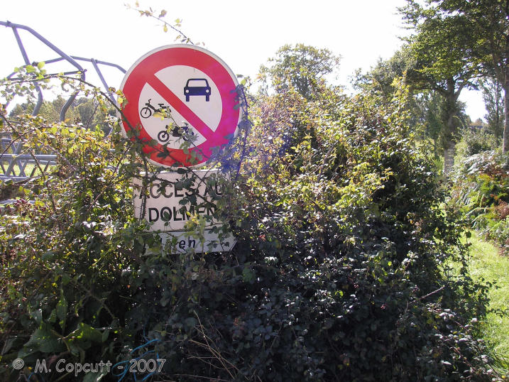
la Loge aux Sarrasins submitted by thecaptain on 28th Sep 2007. Despite the overgrown signs, this looked all very promising, and that I could add this elusive, rare Normandy dolmen to my list !
(View photo, vote or add a comment)
Log Text: Despite an accurate description of how to find this dolmen I could find nothing that looked like the picture from 1980. I did however find some large stones in about the right place a large single stone standing in the middle of the field and a couple of smaller ones with a small stone on top and a further large stone nearby. Perhaps I was looking in the wrong field but I think more likely is that this dolmen has recently been destroyed. A closer inspection of the photographs and I think that the large stone lying near the edge of the field might be the capstone from the dolmen upside down. A criminal shame that these things survive so long only to be destroyed in these modern times due to greed and laziness of a farmer.
Later note. Having seen the 1:25000 ign map of the area the dolmen is marked in a field further to the north than where I was looking beside the farm buildings which begs the question of what are the stones I did find.
Pierre Tourneresse (Gouvix)
Trip No.202 Entry No.8 Date Added: 25th Mar 2020
Site Type: Standing Stone (Menhir)
Country: France (Normandie:Calvados (14))
Visited: Couldn't find on 23rd Apr 2005
Pierre Tourneresse (Gouvix) submitted by Rida on 29th Jan 2011. Site in Normandie:Calvados (14) France
(View photo, vote or add a comment)
Log Text: Not marked on my ign map and finding no map within the village I gave up without really trying to find the supposed menhir near here. I believe it is in the grounds of the local chateau and wasn’t going to spend a lot of time being unable to find it.
Menhir dit Pierre de la Hoberie
Trip No.202 Entry No.15 Date Added: 26th Mar 2020
Site Type: Standing Stone (Menhir)
Country: France (Normandie:Calvados (14))
Visited: Couldn't find on 23rd Apr 2005
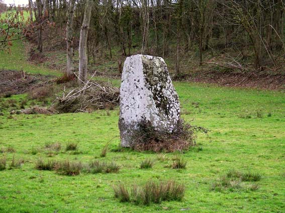
Menhir dit Pierre de la Hoberie submitted by Rida on 27th Feb 2011. Site in Normandie:Calvados (14) France
Menhir dit Pierre de la Hoberie
(View photo, vote or add a comment)
Log Text: This 3.1 metre tall menhir is said to be in the field downhill from the Ferme de Hoberie southwest of the village of Ussy. I could find nowhere to park and see no way through the farm without going through fields of cows so didn’t bother as I was in a rush to get back.
Pierre Tournante (Bosgouet)
Trip No.202 Entry No.97 Date Added: 30th Mar 2020
Site Type: Burial Chamber or Dolmen
Country: France (Normandie:Eure (27))
Visited: Couldn't find on 4th May 2005
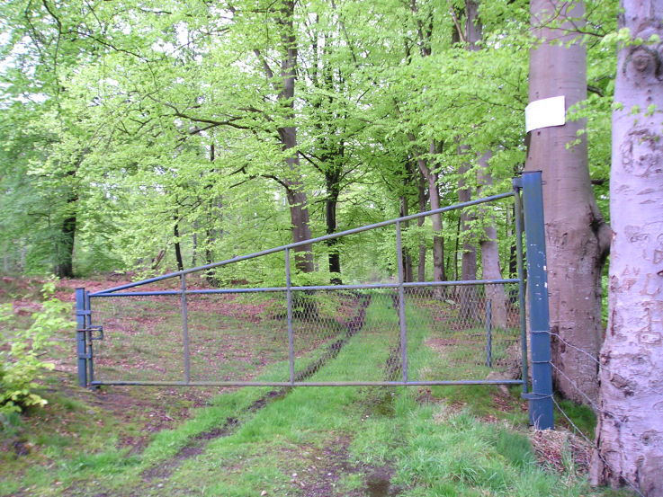
Pierre Tournante (Bosgouet) submitted by TheCaptain on 6th May 2005. Pierre Tournante, Bosgouet, Eure.
When I got there I found that the track through the forest to get to it had been gated off, with lots of barbed wire and keep out notices everywhere, so I didn’t get to visit this one.
(View photo, vote or add a comment)
Log Text: Marked on my ign map as a megalithic monument. When I got there I found that the track through the forest to get to it had been gated off with lots of barbed wire and keep out notices everywhere so I didn’t get to investigate.
