Contributory members are able to log private notes and comments about each site
Sites theCaptain has logged on trip number: 212 (View all trips)
View this log as a table or view the most recent logs from everyone
Langrais menhirs
Trip No.212 Entry No.6 Date Added: 26th Mar 2020
Site Type: Standing Stones
Country: France (Normandie:Calvados (14))
Visited: Yes on 7th May 2012. My rating: Condition 4 Ambience 3 Access 4

Langrais menhirs submitted by Rida on 27th Feb 2011. Site in Normandie:Calvados (14) France
(View photo, vote or add a comment)
Log Text: Having had a good look at the IGN 1:25000 map, I saw that there is a trackway running east from the road south of Mont Joly, which runs from the bottom of the hill diagonally up to the approximate position of the stones. Even better, when arriving there for a look, the trackway was open and easily driveable, and so I took this option on this showery afternoon, and when emerging from below the wood at the top of the hill, there was plenty of space to park amongst a large composting area! Left Dad in the car while I went out into the wind and drizzle to find the stones, and there they were, just round the back of the big pile of manure!
The two stones stand at the edge of an open rocky outcrop at the top of the hill, covered in wildflowers at this time of year, but I learned that the stones are not in their original positions, having been moved there by the farmer at some point in the past. The two stones are very different, the larger stone being a whitish quartz type stone, between 3.5 nd 4 metres tall, while its shorter neighbour is a reddish colour, and only about 1.6 metres tall. There are plently of other large lumps of stone laying about here, which may have been broken from the two menhirs, or just other examples of field clearance.
On the way down from the stones, through a gateway into the wood I could see another rocky outcrop with various large stones standing around, a couple of them probably at least 2 metres tall. This was all now made into a nice garden feature, but is there any ancient significance to the stones? Back onto the road, and I noticed it was called Route des Menhirs, and up towards the top of the hill there was another garden with some large rocks standing in it.
Onto the top of Mont Joly, and it is clear that there are large rocks all over the place, and it is easy to imagine that thee was once an alignement of large stones running along the top of the hill into the ancient settlement. Walking along the edge of the field, and then the pathway to the end of the promontary, and large stones can be seen laying around everywhere, many clearly not just a local outcropping of rock, but various shapes, sizes and types of stone. Many of these rocks were now incorporated into garden features, but many more are just laying there, slowly getting buried by the undergrowth. It really is a fascinating area, and I do wonder what a proper survey of this ancient hilltop would turn up.
Le Wuy Menhir
Trip No.212 Entry No.17 Date Added: 30th Mar 2020
Site Type: Standing Stone (Menhir)
Country: France (Normandie:Seine-Maritime (76))
Visited: Yes on 27th Dec 2012. My rating: Condition 3 Ambience 3 Access 5

Le Wuy Menhir submitted by theCaptain on 1st Jan 2014. Described as a menhir, this site is more likely the remains of a burial chamber of some sort, which has been largely destroyed by agriculture.
(View photo, vote or add a comment)
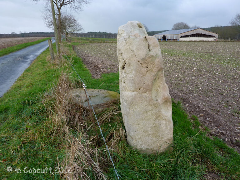
Log Text: Described as a menhir, this site is the remains of a burial chamber of some sorts, which has been largely destroyed by agriculture. The remains I found consist of one large standing stone, about 2 m width and just over a metre in height. Its a lovely slab of sarsen like stone, which is all smooth on the southern face, but all lumpy and holed on the northern face, as sarsen often is. Beside this stone is another slab of sarsen flat to the ground.
I am sure this is not a menhir as described, but a remaining slab from a burial chamber of some sort, whether a side slab or end slab is not clear. It is possible that this stone is not in its original position, but has been moved here to help clear the fields for ploughing.
Mont Joly
Trip No.212 Entry No.8 Date Added: 26th Mar 2020
Site Type: Ancient Village or Settlement
Country: France (Normandie:Calvados (14))
Visited: Yes on 7th May 2012. My rating: Condition 2 Ambience 4 Access 5
Mont Joly submitted by theCaptain on 15th Jan 2014. This promontory site is surrounded on three sides by the steep gorge of the river Laizon, and the eastern end has been defended by ramparts, a little of which can now be seen between the church and water tower.
In this picture a raise in the land can be seen to the left of my Dad.
(View photo, vote or add a comment)
Log Text: What an intriguing place this is, and deserving of much more thorough exploration.
Mont St Michel
Trip No.212 Entry No.13 Date Added: 13th Jun 2020
Site Type: Ancient Village or Settlement
Country: France (Normandie:Manche (50))
Visited: Yes on 11th Oct 2012. My rating: Condition 5 Ambience 4 Access 4

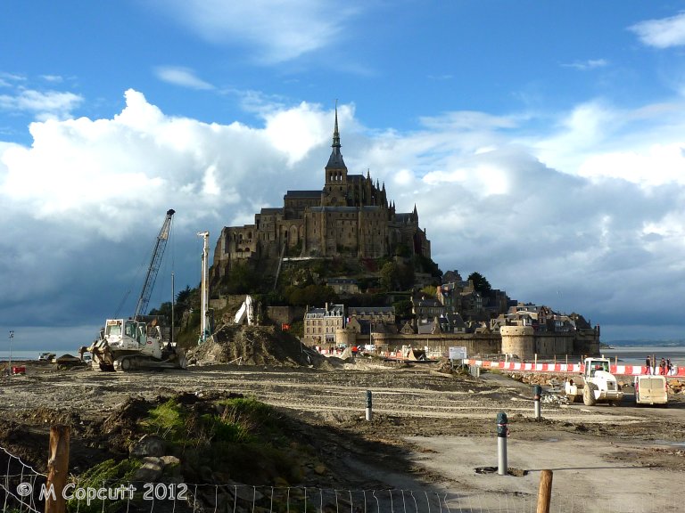
Mont St Michel submitted by theCaptain on 4th Jan 2013. They are trying to cut off the Mont again, to get the sea to surround it once more, and this involves removing the old causeway which prevented the tide clearing the silts etc, and just have a bridge going out to the Mont. This and alterations to the river should then mean the silts get washed away, and the sea once more claims the Mont at each high tide.
(View photo, vote or add a comment)
Log Text: Getting a late lunch at Plein Fougeres, it is now much too late to go to Fougeres and have a proper look round, so we decide to go to Mont St Michel for a quick look around. Shouldn't be too busy at this time of year. It has all changed since either myself or Dad was last there, and you now have to park miles away, at what is becoming a sort of holiday village resort. Many huge car parks, some hotels and restaurants etc, and a 40 min walk to the Mont, but free shuttle busses are provided. At this point I was ready to give up and drive away, but Dad still wanted to persevere, so we got the shuttle bus 10 mins out to the Mont.
Theres a hell of a lot of work going on here, both to the walls and the surroundings. Turns out they are trying to cut off the Mont again, to get the sea to surround it once more, and this involves removing the old causeway etc, and just have a sort of bridge going out to the Mont. This and alterations to the river should then mean the silts get washed away, and the sea once more claims the Mont at each high tide. I read at the new controlling dam on the river that the land has risen 4.9 metres since the 1960s. Much of these new grassy marshes is being dug up and pushed into the river, hopefully to get washed away.
The place is not too crowded, although many Japanese here, so we walk up to the abbey along the main street, no time to do the tour. Walk down around the outer walls, watching the tide coming in, and theres a group of people out walking over the sands and mud with the water coming in. Just as we leave the Mont, the sun starts to come out, making a few pictures much better.
Cup of tea, then on to Sara's, much later than we ought to be, but this time its not all my doing! Must visit here properly sometime, October Thursday mornings might be OK, but need the whole day.
Pierre Trouée de l'allée couverte d'Aizier
Trip No.212 Entry No.18 Date Added: 30th Mar 2020
Site Type: Passage Grave
Country: France (Normandie:Eure (27))
Visited: Yes on 27th Dec 2012. My rating: Condition 4 Ambience 4 Access 5
Pierre Trouée de l'allée couverte d'Aizier submitted by theCaptain on 30th Dec 2012. This wonderful holed stone is today found nicely presented just outside the little church of the village of Aizier, right on the banks of the River Seine. The stone is the portholed entry stone from a now destroyed allée couverte, destroyed during the making of a road.
The stone is about 1.7 metres tall and wide, thickness 22 cm, but the important dimension is that of the circular hole, which is diameter 47 cm, and yes, I did manage to crawl through it!
(View photo, vote or add a comment)
Log Text: This wonderful holed stone is today found nicely presented (since 1976) just outside the little church of the village of Aizier, right on the banks of the River Seine not too far upstream from the Tancarville Bridge, a few miles inland from Le Havre.
The stone is the remains of the portholed entry stone from a now destroyed allée couverte, which was destroyed during the making of the road to Bourneville sometime in the 19th century. The stone is about 1.7 metres tall and wide, with thickness 22 cm, but the important dimension is that of the circular hole, which is of diameter 47 cm, and yes, I did manage to crawl through it!
This type of allée couverte was fairly common in this region, and dates to the final neolithic, -3500 BC to -2800 BC.
