Contributory members are able to log private notes and comments about each site
Sites SandyG has logged. View this log as a table or view the most recent logs from everyone
Standingstone Rigg
Date Added: 29th Jan 2019
Site Type: Stone Row / Alignment
Country: England (Northumberland)
Visited: Yes on 23rd Jun 2018. My rating: Condition 2 Ambience 4 Access 2
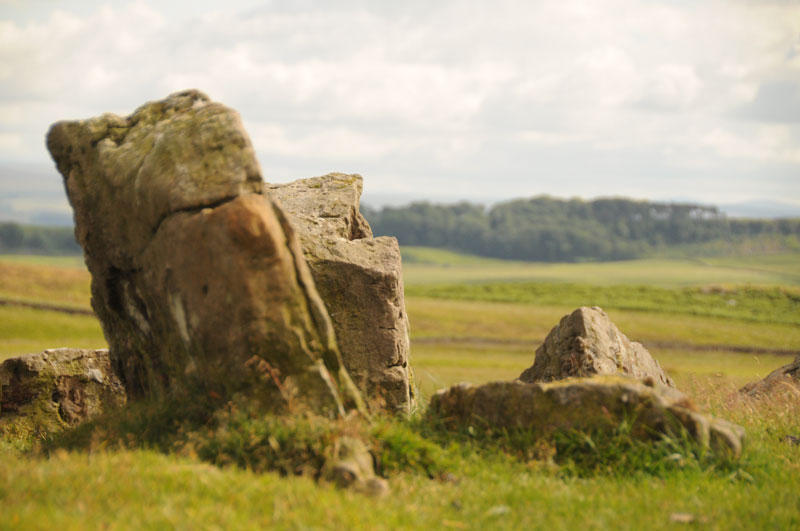
Standingstone Rigg submitted by Anne T on 15th Jul 2014. This photograph is taken from the top of Standingstone Rigg looking south east. The pairing of the stones is identifiable.
(View photo, vote or add a comment)
Log Text: Limited car parking is available at NY 83118 75082. From here follow the track south looking out for the small four-stone circle at NY 82942 74717. Follow the track past Great Lonbrough and onto the access land at NY 81612 73313. From here it is a short walk west to the stones.
There are a number of separate and connected reasons for doubting the prehistoric stone row interpretation of this site:-
In places there seems to be a rubble bank between the upright stones.
At one point near to the sheep fold there is a clear lynchet along the orientation of the feature
At the northern end, the feature descends a very steep slope. No other row is known to do this.
A line of lines at NY 81514 73328 suggests that the feature turns at a right angle and heads east from NY 81499 73317. Severe shifts of alignment such as this are not a characteristic of stone rows but are common in field boundaries
The spacing between the rows is inconsistent
The form of the feature is similar to prehistoric boundary walls
The southern part of the feature is orientated on a pronounced kink in a boundary bank.
On the basis of the available evidence it would therefore appear unlikely that this feature represents the remains of a prehistoric stone row and instead is more likely to be the partly robbed remains of a field boundary, probably of prehistoric date because historic boundaries in the vicinity appear to be of the ditch and bank type.
Lanacombe 5
Date Added: 29th Jan 2019
Site Type: Multiple Stone Rows / Avenue
Country: England (Somerset)
Visited: Yes on 13th Apr 2018. My rating: Condition 1 Ambience 3 Access 3

Lanacombe 5 submitted by TheCaptain on 5th Aug 2007. On the south facing slopes of Lanacombe Hill on Exmoor, above the stream valley, are the remains of this recently found stone setting.
I found many stones and stumps of stones standing proud of the ground, with below them a very marshy area possibly hiding many more. I also found several fallen and part buried stones, long and thin, which were obviously once meant to stand upright.
(View photo, vote or add a comment)
Log Text: Amble car parking is available at SS 76511 43232. From here head south east across the moorland to the site. Only one stone is upright and near to it is a broken stump. A couple of the larger recumbent stones are likely to have once stood upright but most of the stones are probably exposed bedrock. Whilst it is likely that there was a group of standing stones at this location not enough remains to establish their original form and therefore it is not possible to be confident that there was a stone row at this location.
Kenidjack Common holed stones
Date Added: 29th Jan 2019
Site Type: Stone Row / Alignment
Country: England (Cornwall)
Visited: Yes on 9th May 2018. My rating: Condition 3 Ambience 4 Access 3
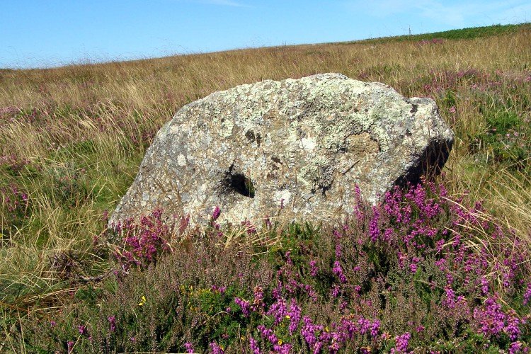
Kenidjack Common holed stones submitted by JimChampion on 24th Oct 2007. August 2007. One of the holed stones on Kenidjack Common, surrounded by flowering bell heather.
(View photo, vote or add a comment)
Log Text: Car parking is available at SW 39343 33369. From here walk west for a short distance along the highway to SW 39191 33324. Head south along the footpath to SW 39081 32899 and enter the common . Follow the track heading south west and then take the path to the south.
The Longstone (Piles Hill)
Date Added: 29th Jan 2019
Site Type: Standing Stone (Menhir)
Country: England (Devon)
Visited: Yes on 9th Mar 2013. My rating: Condition 3 Ambience 5 Access 3
The Longstone (Piles Hill) submitted by SandyG on 27th Sep 2014. The Longstone and friend. The stone on the right is a later boundary marker. There is a history of legal disputes concerning this boundary and the new stone will have been erected to resolve one of these. A remarkable juxtaposition of stones with many stories to tell.
(View photo, vote or add a comment)
Log Text: Car parking is available at SX 64338 59550.
Hobajons Cross
Date Added: 29th Jan 2019
Site Type: Standing Stone (Menhir)
Country: England (Devon)
Visited: Yes on 9th Mar 2013. My rating: Condition 4 Ambience 5 Access 3

Hobajons Cross submitted by SandyG on 27th Sep 2014. Hobajons Cross may be an original terminal stone for the Butterdon Hill stone row which has been Christianised by the cutting of a simple cross on the western face.
(View photo, vote or add a comment)
Log Text: Car parking is available at SX 64338 59550.
Butterdon Hill Row
Date Added: 29th Jan 2019
Site Type: Stone Row / Alignment
Country: England (Devon)
Visited: Yes on 9th Mar 2013. My rating: Condition 3 Ambience 5 Access 3

Butterdon Hill Row submitted by SandyG on 27th Sep 2014. In places along the length of the row the alignment is formed by series of small stones placed very close together. This is a common feature of the Dartmoor rows although their tiny size means that this characteristic is often overlooked.
(View photo, vote or add a comment)
Log Text: Car parking is available at SX 64338 59550. Follow the bridleway heading east for 1.2km. The row crosses the bridleway.
Butterdon Stone Circle
Date Added: 29th Jan 2019
Site Type: Stone Circle
Country: England (Devon)
Visited: Yes on 9th Mar 2013. My rating: Condition 2 Ambience 5 Access 3
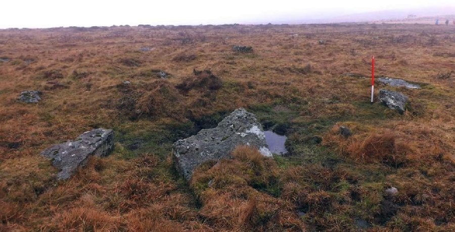
Butterdon Stone Circle submitted by SandyG on 27th Sep 2014. Cairn at the southern end of the row. The large recumbent slabs surround the cairn and probably represent either a once impressive kerb or stone circle.
(View photo, vote or add a comment)
Log Text: Car parking is available at SX 64338 59550.
Butterdon East
Date Added: 29th Jan 2019
Site Type: Stone Row / Alignment
Country: England (Devon)
Visited: Yes on 4th May 2018. My rating: Condition 2 Ambience 4 Access 2
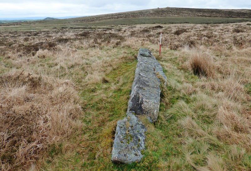
Butterdon East submitted by SandyG on 4th Jan 2019. Eastern stone. A substantial fallen pillar measuring 5m long stands up to 0.56m above the surrounding ground. View from west (Scale 1m).
(View photo, vote or add a comment)
Log Text: Car parking is available at SX 64338 59550. Follow the bridleway heading east for 1.4km then head south. There is plenty to see in this area.
Spurrells Cross Row
Date Added: 29th Jan 2019
Site Type: Multiple Stone Rows / Avenue
Country: England (Devon)
Visited: Yes on 9th Mar 2013. My rating: Condition 2 Ambience 4 Access 3
Spurrells Cross Row submitted by SandyG on 28th Feb 2015. This row is being enveloped by encroaching moorland grass and gorse. At this rate within a few years it will not longer be visible (9th March 2013).
(View photo, vote or add a comment)
Log Text: Car parking is available at SX 64338 59550. Follow the bridleway heading east for 1.4km. The row is on the southern side of the bridleway.
Harford Moor N
Date Added: 29th Jan 2019
Site Type: Stone Row / Alignment
Country: England (Devon)
Visited: Yes on 25th Apr 2013. My rating: Condition 2 Ambience 4 Access 4

Harford Moor N submitted by thecaptain on 22nd Jul 2004. Harford Moor North, Dartmoor, Devon SX652599
At the upper reaches of Butterbrook are a double and a single row of stones, on a similar alignment. The northern single row crosses beyond the end of the double row. The stones are smaller than those of the double row, some hardly showing above the ground, and not easy to see in all the loose natural stone of the area. There is no obvious western end to the row, and the furthest stones here are more or less adjacent to the cairn of the double row...
(View photo, vote or add a comment)
Log Text: Car parking is available at SX 64338 59550. Follow the bridleway heading east for 850m. The row is a short distance to the north of the bridleway.
Butterbrook
Date Added: 29th Jan 2019
Site Type: Stone Row / Alignment
Country: England (Devon)
Visited: Yes on 25th Apr 2013. My rating: Condition 2 Ambience 4 Access 4
Butterbrook submitted by SandyG on 26th Sep 2014. Cairn standing a short distance south west of the stone rows. View from north east.
(View photo, vote or add a comment)
Log Text: Car parking is available at SX 64338 59550. Follow the bridleway heading east for 850m. The row is a short distance to the north of the bridleway.
Burford Down Cairn Circle
Date Added: 29th Jan 2019
Site Type: Stone Circle
Country: England (Devon)
Visited: Yes on 2nd May 2018. My rating: Condition 2 Ambience 4 Access 3
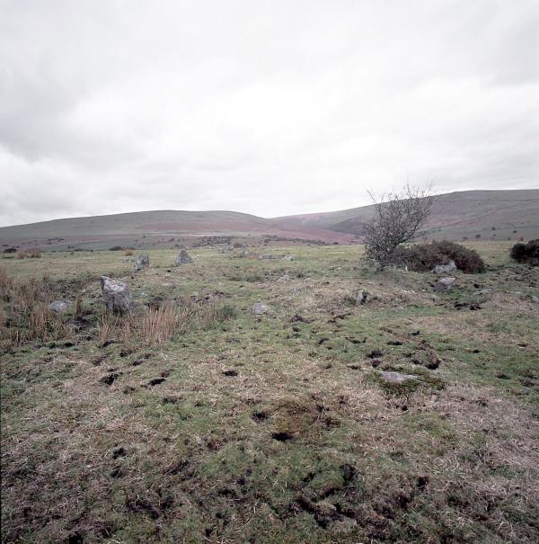
Burford Down Stone Row submitted by Tom_Bullock on 9th Jul 2002. The Burford Down stone row, one of the finest in
Dartmoor, shows evidence of recent damage by whatever farmer is running
huge tractors across the fields. S(he) has been driving right through
the rows (perpendicular to them) along several tracks. I saw evidence of
at least 3 stones that had been dislodged and pushed aside by the wheels
of the tractor. I don't know if there is a procedure for reporting such
damage, or even if the farmer is liable for such damage. I have never, in my 12 year...
(View photo, vote or add a comment)
Log Text: Very limited car parking is available at SX 62102 60910. Care should be taken to ensure that the highway is not restricted and access to the adjacent field is not obstructed. From here walk eastward up the lane and follow the footpath to the Erme Valley to SX 63582 61142. From here head south to the row passing the Stalldown SE stone row on the way.
Glasscombe Ball North
Date Added: 29th Jan 2019
Site Type: Stone Row / Alignment
Country: England (Devon)
Visited: Yes on 9th Mar 2013. My rating: Condition 2 Ambience 4 Access 2
Glasscombe Ball North submitted by SandyG on 29th Sep 2014. A line of prostrate granite slabs protruding through dead molinia does not offer a great photographic opportunity. One day I will return with my pole and see if I can improve on this offering. The fact that no stones remain standing strongly supports the idea that they have been deliberately felled. View from the north east with the terminal cairn on the skyline.
(View photo, vote or add a comment)
Log Text: Car parking is available at SX 64338 59550. Follow the bridleway heading east to SX 65769 59963 where the track of a disused railway line is encountered. Follow this north to SX 65716 60429. The row is situated close to this point. A visit to this row should be combined with others in the vicinity.
Glasscombe Ball NE
Date Added: 28th Jan 2019
Site Type: Multiple Stone Rows / Avenue
Country: England (Devon)
Visited: Yes on 9th Mar 2013. My rating: Condition 3 Ambience 4 Access 3
Glasscombe Corner Stone Row submitted by SandyG on 29th Sep 2014. View from the north east along the row.
(View photo, vote or add a comment)
Log Text: Car parking is available at SX 64338 59550. Follow the bridleway heading east to SX 65769 59963 where the track of a disused railway line is encountered. Follow this north to SX 65716 60429. The row is situated 420m north east of this point. A visit to this row should be combined with others in the vicinity.
Stalldown South East
Date Added: 28th Jan 2019
Site Type: Stone Row / Alignment
Country: England (Devon)
Visited: Yes on 2nd May 2018. My rating: Condition 3 Ambience 4 Access 3
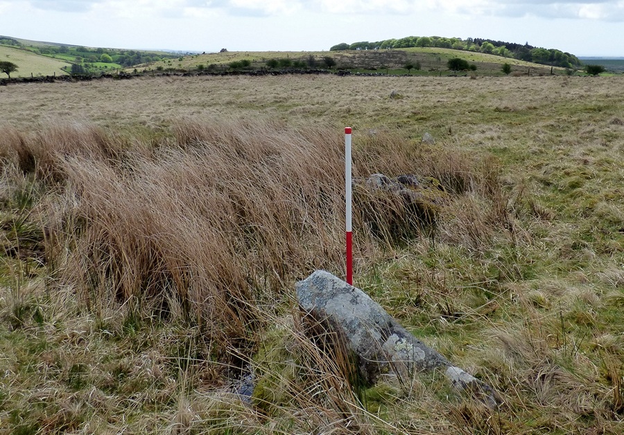
Stalldown South East submitted by SandyG on 29th Jan 2019. View from north of Stone 1 (Scale 1m).
(View photo, vote or add a comment)
Log Text: Following closure of the New Waste car park very limited parking is available at SX 62100 60913. From here walk up the road to SX 62784 61273 and follow the footpath to the right to SX 63560 61141. From here it is a short walk downslope to the row.
Piles Hill NE
Date Added: 28th Jan 2019
Site Type: Multiple Stone Rows / Avenue
Country: England (Devon)
Visited: Yes on 9th Mar 2013. My rating: Condition 2 Ambience 4 Access 3
Piles Hill NE submitted by SandyG on 26th Feb 2015. All of the stones in this row are now recumbent. When standing this must have been spectacular indeed. (9th March 2013)
(View photo, vote or add a comment)
Log Text: Car parking location is available at SX 64342 59548. From here head east to the Two Moors Way at SX 65765 59965. Then follow the track north to SX 65388 61077 where it crosses the row.
Corringdon Ball
Date Added: 28th Jan 2019
Site Type: Multiple Stone Rows / Avenue
Country: England (Devon)
Visited: Yes on 9th Jun 2013. My rating: Condition 3 Ambience 4 Access 2

Corringdon Ball submitted by thecaptain on 24th Oct 2004. Corringdon Ball site overview.
This is the view looking southwest from Brent Fore Hill, overlooking the Corringdon Ball site. I have tried to mark out the various sites.
In the background is the Butterdon Hill to Piles Hill ridge with its enormous number of sites. Again, I have tried to mark out the various rows and features which would be seen in this view.
(View photo, vote or add a comment)
Log Text: Car parking is available at SX 68060 62906. Walk south along the public highway to SX 67931 62316. From here follow the footpath up the hill onto the open moorland.
Corringdon Ball South
Date Added: 28th Jan 2019
Site Type: Multiple Stone Rows / Avenue
Country: England (Devon)
Visited: Yes on 9th Jun 2013. My rating: Condition 2 Ambience 4 Access 2

Corringdon Ball South submitted by TheCaptain on 2nd Jul 2004. Corringdon Ball S, Dartmoor, Devon SX666612
View eastwards over the remains of the southern multiple rows.
hard to pick out much in the picture, but there are the remains of 7 or 8 rows of small stones here.
(View photo, vote or add a comment)
Log Text: Car parking is available at SX 68060 62906. Walk south along the public highway to SX 67931 62316. From here follow the footpath up the hill onto the open moorland.
Corringdon Ball N.
Date Added: 28th Jan 2019
Site Type: Stone Row / Alignment
Country: England (Devon)
Visited: Yes on 9th Jun 2013. My rating: Condition 2 Ambience 4 Access 2
Corringdon Ball N. submitted by SandyG on 27th Sep 2014. Stones denoting the eastern side of the cairn at the eastern end of the multiple stone rows. On the skyline Corringdon Ball chambered cairn is clearly visible.
(View photo, vote or add a comment)
Log Text: Car parking is available at SX 68060 62906. Walk south along the public highway to SX 67931 62316. From here follow the footpath up the hill onto the open moorland.
Brent Fore Hill
Date Added: 28th Jan 2019
Site Type: Multiple Stone Rows / Avenue
Country: England (Devon)
Visited: Yes on 9th Jun 2013. My rating: Condition 3 Ambience 4 Access 2
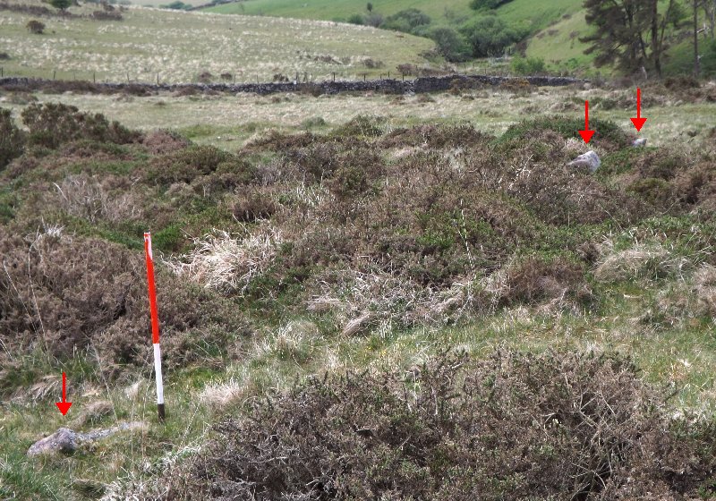
Brent Fore Hill submitted by SandyG on 26th Sep 2014. Three stones hiding among the gorse. View from north east.
(View photo, vote or add a comment)
Log Text: Car parking is available at SX 68060 62906. Walk south along the public highway to SX 67931 62316. From here follow the footpath up the hill onto the open moorland.
